The Black Butte Mine is a mercury mine located in Lane county, Oregon at an elevation of 2,001 feet.
About the MRDS Data:
All mine locations were obtained from the USGS Mineral Resources Data System. The locations and other information in this database have not been verified for accuracy. It should be assumed that all mines are on private property.
Mine Info
Elevation: 2,001 Feet (610 Meters)
Commodity: Mercury
Lat, Long: 43.57417, -123.06194
Map: View on Google Maps
Satelite View
MRDS mine locations are often very general, and in some cases are incorrect. Some mine remains have been covered or removed by modern industrial activity or by development of things like housing. The satellite view offers a quick glimpse as to whether the MRDS location corresponds to visible mine remains.
Black Butte Mine MRDS details
Site Name
Primary: Black Butte Mine
Commodity
Primary: Mercury
Location
State: Oregon
County: Lane
District: Black Butte
Land Status
Land ownership: Private
Note: the land ownership field only identifies whether the area the mine is in is generally on public lands like Forest Service or BLM land, or if it is in an area that is generally private property. It does not definitively identify property status, nor does it indicate claim status or whether an area is open to prospecting. Always respect private property.
Holdings
Not available
Workings
Type: Underground
Ownership
Owner Name: Black Butte Mining Inc.
Owner Name: Cone Lumber Co.
Years: 1978 -
Production
Year: 1968
Time Period: 1897-1968
Material type: ORE
Description: Cp_Grade: ^3.5 Lbs Hg/Ton
Year: 1968
Time Period: 1900-1968
Material type: HG
Description: Cp_Grade: ^5 - 6 Lb/Ton
Deposit
Record Type: Site
Operation Category: Past Producer
Operation Type: Surface-Underground
Year First Production: 1900
Year Last Production: 1968
Discovery Year: 1890
Discovery Method: Ore-Mineral In Place
Years of Production:
Organization:
Significant: Y
Deposit Size: M
Physiography
General Physiographic Area: Pacific Mountain System
Physiographic Province: Pacific Border Province
Physiographic Section: Oregon Coast Range
Mineral Deposit Model
Not available
Orebody
Not available
Structure
Type: L
Description: Black Butte Fault
Alterations
Alteration Type: L
Alteration Text: Widespread Clay, Carbonate And Silica Alteration And Impregnation Of Host Rocks; Supergene Limonite
Rocks
Name: Tuff
Role: Associated
Age Type: Associated Rock
Age Young: Pliocene
Name: Tuff
Role: Associated
Age Type: Host Rock
Age Young: Eocene
Analytical Data
Analytical Data: RECOVERY AVERAGED 3.5 LBS HG/TON OF ORE, 1900-1968.
Materials
Ore: Metacinnabar
Ore: Mercury
Ore: Cinnabar
Gangue: Sericite
Gangue: Chlorite
Gangue: Pyrite
Gangue: Quartz
Gangue: Siderite
Gangue: Calcite
Gangue: Chalcedony
Gangue: Marcasite
Comments
Comment (Reserve-Resource): ITEM 1 IS APPROX 3000 FL., MAY BE DOWNWARD AND LATERAL EXTENSIONS.
Comment (Location): NW/4 SEC 16
Comment (Deposit): RECORD (W017069) MERGED WITH THIS RECORD AND DELETED FROM OREGON FILE.
Comment (Geology): GEOL.DESC: ANDESITIC LAVA AND TUFF OF TERT. CALPOOYA FM CUT BY MAJOR LOCAL FAULT.
Comment (Workings): PRODUCTIVE YEARS WERE 1900-1901, 1905, 1908-1909, 1916-1919, 1927-1943, 1951, 1956-1957, 1964-1968.
Comment (Deposit): SOME ORE POCKETS ARE 40 FT BY SEVERAL HUNDRED FT. LONG. ORE OCCURS IN SILICA SIDERITE VEINS. INDIVIDUAL VEINLETS GEN. LESS THAN 1 INCH THICK
Comment (Production): PRODUCTIVE YEARS WERE 1900-1901, 1905, 1908-1909, 1916-1919, 1927-1943, 1951, 1956-1957, 1964-1968.
Comment (Exploration): 1956 DIREXPL DMEA, FURNACED ORE FROM 2 LEVEL
Comment (Deposit): Copied from deleted record 10225278 (MAS 0410390015): Orebody Info: Length: 497 M Width: 227 M Depth to Top: 0 M Thickness: 5 M Strike: N70W Dip: 60E MAS Matrix # : 1 MAS Column # : 1 Type of Orebody #1 : SHEAR ZONE Shape of Orebody #1 : TABULAR Type of Orebody #2 : BRECCIA FILL Type of Orebody #3 : DISSEMINATED Primary mode of Origin : HYDROTHERMAL Primary Ore Control : FRACTURING Secondary Ore Control : FRACTURING Degree of Wallrock Alter. : INTENSE Type of Wallrock Alter. #1 : OTHER Type of Wallrock Alter. #2 : SILICIFICATION Type of Wallrock Alter. #3 : CARBONITIZATION Strike And Dip : N70W:60E Minimum Depth to Top : 0 Avg. Thick. Unconsol. Mat. : 0 Min. Thick. Unconsol. Mat. : 0 Date of Last Modification : 830316
References
Reference (Deposit): SCHUETTE, C. N., 1938, QUICKSILVER IN OREGON: ODGMI BULL. 4, P. 138-145
Reference (Deposit): MERCURY IN OREGON, 1965 , USBM IC 8252, table 26, p. 319.
Reference (Deposit): BAILEY, E. H., USGS, PERSONAL FILES
Reference (Deposit): BROOKS, H. C., 1963 , QUICKSILVER IN OREGON: OREGON DEPT. OF GEOLOGY AND MINERAL INDUSTRIES, BULL. 55 , 223 P.
Pages: p. 35-40.
Reference (Deposit): WATERS, A. C., 1945, THE BLACK BUTTE QUICKSILVER MINE, LANE COUNTY, OREGON: USGS STRATEGIC MINERALS REPORT, OPEN FILE
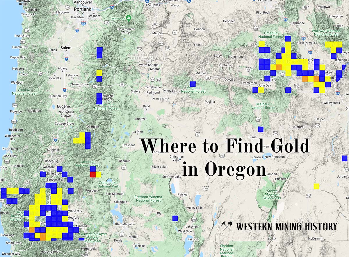
Oregon Gold

"Where to Find Gold in Oregon" looks at the density of modern placer mining claims along with historical gold mining locations and mining district descriptions to determine areas of high gold discovery potential in Oregon. Read more: Where to Find Gold in Oregon.