John M. Shannon and Geraldine C. Shannon
Colorado School of Mines
Geology Museum
Golden, Colorado 80401
This copyrighted material is the property of The Mineralogical Record, and is published here with permission. The article originally appeared in The Mineralogical Record, volume 16, May-June, 1985.
The Colorado Mining Directory of 1883 called Leadville the “natural successor to Australia and California.” In the century since that statement was made, interest has never waned and production has never entirely ceased. Not only valuable ore but also fine mineral specimens have been recovered and preserved from many of the nearly 2000 mines in the Leadville area.
Introduction
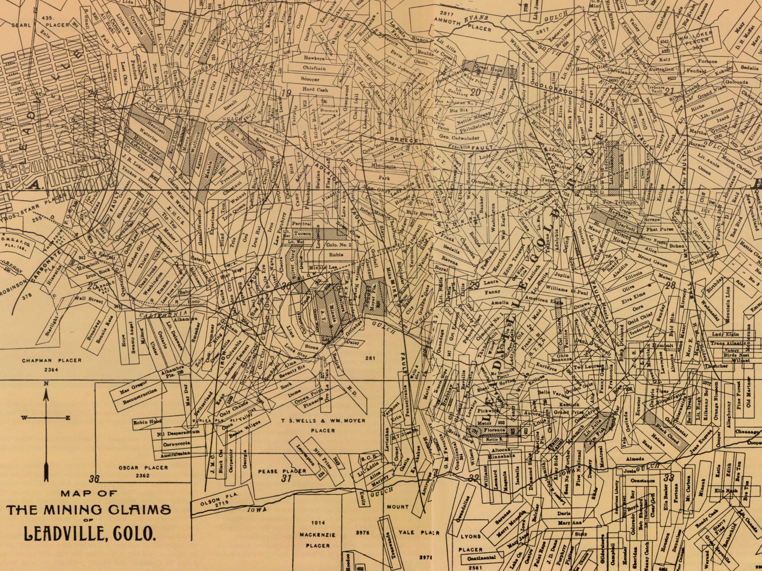
The town of Leadville is located on the western edge of the Leadville mining district, on the western slope of the Mosquito Range, in Lake County, Colorado, about 128 km (80 miles) southwest of Denver. Altitudes range from 3070 to 4000 meters (10,000 to 13,000 feet), and the mountain scenery in that area of Colorado is spectacular. Leadville is one of Colorado’s great mining districts, with a long and complex history. Historical material gathered for this article gives preference to those mines of greatest mineralogical interest.
Table of Contents
Discovery
Mining
Geology
About Some of the Mines
Minerals
Acknowledgements & Bibliography
Discovery
Gold!!!
The rush had begun.
Those who found themselves left out at Mountain City and other Gilpin mines continued to push relentlessly onward. Prospectors, their numbers fed by the thousands who flocked to the West in the aftermath of the terrible financial panic of 1857, pressed forward throughout the summer and fall of 1859. Into areas now known as Georgetown, Boulder, Gold Hill, Tarryall, Fairplay and over the low divide into the Arkansas Valley they drove, always in search of the yellow metal. When winter came they returned to Auraria and Denver to wait for another season to continue the search.
Finally, on February 15, 1860, A. G. (Al) Kelley (sometimes spelled Kelly) led 25 men from Auraria via Colorado City and Ute Pass across South Park, over the Mosquito Range to the west, probably via Trout Creek Pass, to the upper Arkansas River to a spot he had prospected the previous fall. This first group to work the Arkansas River chose a site that was approximately 32 km (20 miles) south of present-day Leadville; they called it “Kelley’s Diggings,” “Kelleysburg” or “Kelley’s Bar” (Smiley, 1901; Blair, 1980).
Meanwhile, another miner who had also prospected the Arkansas Valley briefly that fall of 1859 told S. S. Slater in Mountain City (near what is now Central City) of a rich placer he had located. Although Smiley (1901) gives Currier as leader of the group organized to search out this placer, Slater seems to be the one who figured most prominently.
In any case, a small party from Mountain City journeyed down Bear Creek, up the South Platte and across South Park to the Mosquito Range. They did not cross Trout Creek Pass, the easiest access to the Arkansas Valley, but apparently entered the area via a pass immediately east of present-day Granite (Smiley, 1901; Griswold, 1951; Blair, 1980). Because their information indicated that they should continue north, this second party did not prospect at Kelley’s Bar, but went on.
At this point there are discrepancies in the accounts of the Slater party and of how California Gulch and lowa Gulch came to be discovered and named. The popular view is that at Cache Creek others threw in with them, and in Hayden Flats this larger Slater group encountered the Jones party. The latter had also heard of good prospects in the mountains and had also come from Mountain City (Blair, 1980).
The Slater party and the Jones party combined and agreed to divide “into three groups: (a) Iowans led by Jones would prospect the first likely gulch, (b) Slater’s bunch (later called ‘Stevens’ group’) from Mountain City would prospect the second likely gulch, and (c) a third group, which seems to have been made up of odd lots and led by a stranger named Johnson, would prospect the western side of the valley along the base of Mt. Massive” (Blair, 1980).
Iowa Gulch bears the name the Jones group gave it. Stevens’ group prospected a gulch about 2.4 km (1/2 miles) north of Iowa Gulch, and, finally, Abe Lee found “a pan that promised to make rich men of them all” (Blair, 1980). Soon thereafter this gulch was named California Gulch, from which “a number of the largest and most valuable nuggets known to the country were taken out” (Hall, 1889).
The reason for the name is also controversial. “Most old-timers claimed the gulch was so named from Abe Lee’s memorial words, ‘By God, I’ve got California in this here pan. Others protested the gulch derived its name from the fact that the majority of the first prospectors had come from California (mining camps). A third group held that the name grew out of the early-comers’ predictions that the diggings’ would be as rich as those of California” (Griswold, 1951).
Even the date of discovery is disputed (Smiley, 1901; Griswold, 1951; Blair, 1980), but “They reported it at the Kelley Diggings – which in the meantime had not ‘panned out as well as had been expected – on the evening of April 25th” (Smiley, 1901). “The official ‘Bylaws of California Mining District, California Gulch, Arkansas River’ were adopted on May 12, 1860. They first outlined the extent of the district” (Blair, 1980).
The Johnson party, the third group prospecting, tried their hand in California Gulch, but soon returned to the gulch they had previously worked at the base of Mount Massive. Using a skillet to pan the dirt, they found gold there and named this creek opposite California Gulch, Frying Pan Gulch. (It was later renamed Colorado Gulch [Griswold, 1961].) The Colorado Mining District was formed by the Johnson party (Blair, 1980).
The following two reports are examples of the type of information that caused the rush to Leadville.
“Mr. H. A. Rogers has shown us some of the finest specimens of nugget gold we have seen taken out of the Mountains. . . . He had in his possession about $200 in nugget gold, varying in value from $5 to up to $33.10. It was taken from his claims, No. 2 and No. 4 in California Gulch. He also showed us over four pounds of fine gold taken from the same claims. Mr. R. was on his way to St. Joseph for goods, and will return in a few weeks. He gives a glowing account of the mining prospects in California Gulch” (The Rocky Mountain News, August 29, 1860).
“On Wednesday eve of last week two rough-looking individuals, sunburned and shaggy, entered the office of Pikes Peak Express Co., bearing sacks upon their shoulders which they deposited upon the counter like bags of corn. … Then causing door to be closed, they opened their pouches and emptied them of $27,000 in gulch gold. … The shining dust, whose luster had never been dimmed by any retorting process, glittered with peculiar brilliancy and abounded in nuggets, largest of which were twice the size of silver dollars. … Owners of the treasure are two miners just in from California Gulch. … Their names were J. M. Rafferty from Ohio and George Stevens from Philadelphia” (The Mountaineer, September 26, 1860).”
“Following this period placer operations were carried on in a small way, the seasons’ yields often being no more than about $20,000. It had been noticed, however, that certain heavy stones accumulated in the sluice-boxes to the annoyance of the placer miners. While it is true that many of the men were ignorant of the nature of these stones, it soon become more or less a matter of general knowledge that they were nodules of lead carbonate. Lead minerals, unless excessively rich in silver, were in the late sixties and early seventies of no value, owing to the distance from the few smelters at that time in existence west of the Mississippi. Men busy at placering could not afford to spend any time in saving or looking for deposits of such comparatively worthless minerals” (Warwick, 1905).
Sometime during the first five years of the 1860s, the first and one of the most famous lodes of the Leadville area, the Printer Boy, was discovered in California Gulch. Due to improper management, however, its full potential was not realized until 1868, when large masses of free gold were found.
Once these and other discoveries became known, men flocked in and a “camp” developed. The first unofficial, overall name of the settlement, which was scattered in a most unorderly manner for about 9.6 km (6 miles) up and down the gulch, was Boughtown, a name of “appearance” (Griswold, 1961). According to the Daily Chronicle of April 7, 1879, “Men in those days were in too much of a hurry to even build houses to live in; they contented themselves generally with erecting four posts and covering the tops and sides with green pine boughs.”
In this area grew “Oro City, as it was finally dubbed, (and it) became the social and economic hub of the area. It had one long main street that ran the length of California Gulch. . . . Oro City was one of the few communities that really served the needs of its citizens. It never required people to move to town; rather it followed the people. In its early years it was scattered up and down California Gulch; as the population diminished and those remaining clustered in the upper end of the gulch, that became Oro City. Then in 1868 the Printer Boy drew miners up the gulch and Oro City followed. In fact, in amoebic fashion, the town split into Upper and Lower Oro. The official site of Oro City was wherever the Post Office was located, and in 1868 that was Upper Oro, or Oro Number Two as it was occasionally called” (Blair, 1980).
The most productive years of placer mining in California Gulch were from 1860 to 1867; however, by 1871 placering continued there with decreased yield and a stamp mill treated ores from several lode mines. “In 1873 only a few placers were worked. Several rich gold strikes were made on lodes in California Gulch, and the Homestake mine (near Tennessee Pass) was reported to be shipping to Golden, ore that carried 30-60 percent lead and 200-500 ounces of silver. In 1874 there was little placer mining, and most of the old, lower ground was regarded as worked out, but many new ditches were being built to carry water to higher ground. The Homestake mine shipped some argentiferous galena containing nickel, but there was no market near at hand for silver ores” (Henderson, 1926).
A third period in the history of the area, the carbonate period, began around 1874, when William H. Stevens and Alvinus B. Wood formed a partnership in order to construct a 19-km (12-mile) ditch to transport water (from the Arkansas River) to California Gulch to assist with sluicing operations, in hopes of discovering new placers and veins. “The original plans contemplated applying the hydraulic process to the new ground now covered by the southwestern half of the city of Leadville” (Hall, 1889; Blair, 1980). The ditch “was an immediate success after its completion in 1875, except that Wood and Stevens were plagued with that same heavy black sand that had confounded placer operations in the gulch since those halcyon days of 1860.” They collected samples from the gulch; an Alma assayer showed the ore “ran twenty-seven percent lead and fifteen ounces of silver to the ton” (Blair, 1980).
Keeping this new secret, “Wood and Stevens quietly prospected the upper slopes of the gulch until they located an outcropping in the area that Stevens had surveyed in 1865” (Blair, 1980). When samples showed it contained a high percentage of lead and 20 to 40 ounces of silver, they “did not make their discovery known until they were in a fair way to secure government titles to nine claims. These were taken up lengthways along what they considered the crest or apex of the lodes” and crossed the gulch, extending high up on the hills (Fossett, 1880). “By the fall of 1875 they controlled a considerable portion of California Gulch” (Blair, 1980).
The names of the principal locations commencing at the south were the Dome, Rock, Stone, Lime, Bull’s Eye and Iron claims. The ore was first found in place on the Rock claim, where it was over 10 feet thick. It was rich in lead, but carried only a small amount of silver (Fossett, 1880). Stevens was a promoter knowledgeable in mining matters, but Wood on the other hand was a mining engineer and trained metallurgist (Blair, 1980).
While they are given credit for the discovery of the Leadville carbonates that led directly to the silver boom in the late seventies, there is ample evidence that the presence of silver in the general area had been known for years, as previously mentioned. One source claimed that as early as 1871 it was not only known that lead existed on the site of Stevens’s Rock mine, but also that the ore was put to a practical use – that of making bullets (Blair, 1980). That the miners were also well aware of the presence of silver is evidenced by this quote from the Rocky Mountain News of November 14, 1860: “We have been shown some beautiful specimens of pure silver ore, from the Washoe, Chicago and Paul’s leads, which are situated about fifteen miles from California Gulch. Portions of the ore have been smelted, and globules of pure silver are attached to the fragments.”
“Rather than discovery, (Wood and Stevens) were responsible for locating the first paying silver lode in California Gulch and having the financial resources and technical knowhow to develop their find” (Blair, 1980).
The successful establishment of lead smelters to treat Georgetown silver-lead ores, and the erection of smelters near Alma and at near-by Malta soon induced numerous other miners to look for the source of the lead minerals known from earlier years (Warwick, 1905).
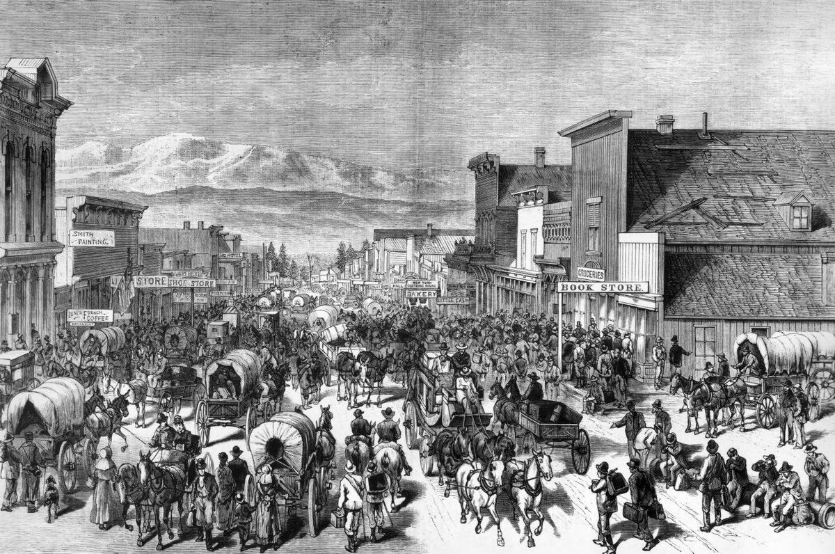
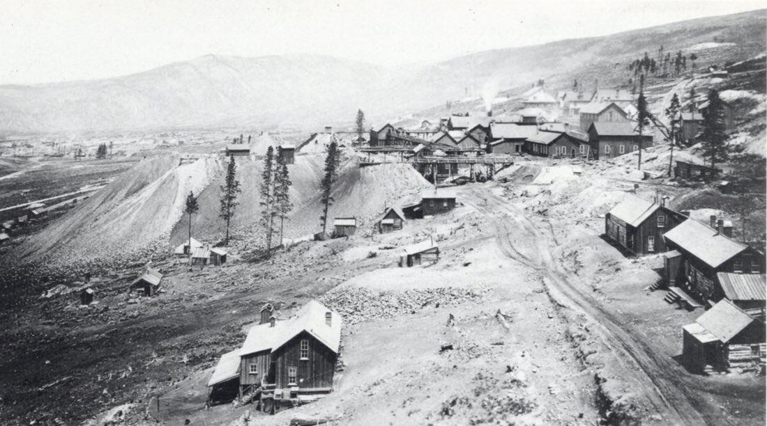
“In 1877–78 the greatest rush to any camp in the history of the state occurred, resulting in the building of a new town, called Leadville, seven miles below the old town of Oro” (Henderson, 1926).
The name was derived from that decided upon when requesting a new post office for the area in 1877. “Naming the post office did not necessarily name the town, but by the fall of 1877 the name was in general use throughout Colorado. When the city framers met in January of 1878, they had either to approve ‘Leadville’ or come up with an acceptable substitute.” Eventually “Leadville” was accepted unanimously and Governor Routt was petitioned “to allow them to establish a recognized city.” This was accomplished by the spring (Blair, 1980).
It was also during this period that many of the mines which then and later produced superb mineral specimens were first staked: 1876, the Wolftone mine; 1877, the Moyer mine; 1878, the Matchless mine; 1879, the Little Jonny mine; 1880, the Resurrection mine; and 1881, the Tucson mine. (See section following entitled “About Some of the Mines.”)
“North of the established mines of Iron, Breece and Carbonate hills lay an area that the experts claimed was barren. To this barren ground came George H. Fryer (in 1878)” (Blair, 1980), “who sunk a hole on a hill north of Stray Horse Gulch and found a deposit of carbonate ore that proved to be one of the most remarkable ore bodies ever discovered” (Henderson, 1926). “The mine was called the New Discovery to spite the experts” (Blair, 1980). Eventually this mine was sold to Jerome B. Chaffee.
Mining
Two poor German shoemakers, August Rische and George Hook, who had been grubstaked by Tabor (Blair, 1980), “happened to sink a hole where the ‘contact’ or the mass of the ore approached the surface and found the ore body on which was developed the Little Pittsburg mine, the foundation of the fortune of H. A. W. Tabor” (Henderson, 1926). On May 15, 1878, they “struck carbonate ore that ran 200 ounces of silver to the ton” (Blair, 1980). By 1882 production had increased to an output valued at $10,139,765 (Henderson, 1926). This value was based on a per-ounce price of $1.14.
During 1883 “Iron Hill continued to be the largest producing district from the Iron Silver, A. Y., Minnie, Colonel Sellers, Tucson and other mines. The Little Jonny mine was actively worked, the product being silver-lead ores carrying some gold” (Henderson, 1926). “In the first decade of the carbonate era, 1879-1888, it produced $146,342,000 in silver, lead, gold and copper” (Warwick, 1905).
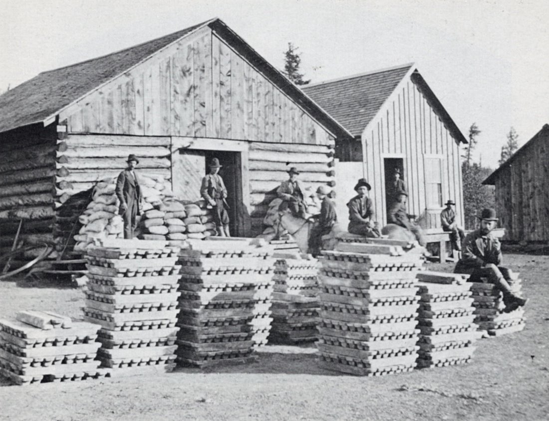
It was also in 1883 that a visitor to Leadville could see the Leadville Free Museum. “It is a rare treat, and one that every visitor to Leadville should avail himself of, to see the mineral and natural curiosities and the mercantile museum of Messrs, Westover and Fuller. They have every imaginable mineral wonder mounted and unmounted that is known to Colorado, which is the same as saying ‘which was ever known to the world.’ They also carry a large collection of petrified woods of every imaginable shape and uniqueness. . . . Messrs, Westover and Fuller have had many years valuable experience in their present line of business, and are continually adding new and rare specimens to their collections. They not only supply rare articles to residents for their own use or to send eastern friends and furnish every eastern visitor with souvenirs, but fill orders from metropolitan jewelers, colleges, private collectors, etc.” (Leading Industries of the West, 1883).
“In 1890, a large deposit of copper ore was found in the Henriette and Maid of Erin properties. In 1893 Lake County began to produce considerable gold, chiefly from properties on Breece Hill.” In that same year, “American Smelting and Refining Company organized and took over nearly all lead smelters of the Rocky Mountain States” (Henderson, 1926).
After the fall in the price of both silver and lead in the early 1890s and a disastrous miners’ strike in 1896, it took a cooperative effort from the town of Leadville to revive mining there. The DownTown Pumping Association was formed to assist with the financing necessary to drain the “downtown” mines, which had been flooded during the strike. The Home Mining Company, supported largely by Leadville merchants, was also organized. The success of these organizations encouraged miners and restored prestige to the district (Warwick, 1905).
During the period from 1899 to 1915, zinc became the important mining product of the Leadville area. Zinc mills were established and shipments of zinc sulfides became quite large. Numerous large bodies of zinc carbonate were found in 1910, many in the old workings.
In 1915 “output of gold from Breece Hill mines increased greatly and the placer industry was revived, after years of non-existence, by the installation of a dredge on the Arkansas River at the mouth of Box Creek, 12 miles above Leadville. In June, 1916, the downtown mines, which had been allowed to fill with water in 1907, were again unwatered and from 1917 to 1923, when they were again closed, they produced large quantities of lead oxide, zinc carbonate, iron-manganese and other ores. In August, 1923, unwatering by electric pumps was begun in the Carbonate Hill mines that had been closed in 1918-1919. The water was not completely removed until the spring of 1925” (Henderson, 1926).
The years between 1918 and 1940 saw many ups and downs in the mining at Leadville. Several small booms took place during these years, brought about by a demand for some of the metals or a chance discovery of a new pocket or small orebody, but these always seemed to play out, resulting in a period of inactivity.
Mining became active once again as a result of the demand for metals during World War II and on into the Korean conflict. In 1943 the government appropriated money for a 4-km drainage tunnel to drain the Leadville district. It was hoped the tunnel would open large deposits of lead, zinc and manganese ores for production, but the project was halted in 1952 because of rising costs and a decline once again in metal prices.
In recent years mining has been carried on with the discovery of a block of down-faulted ore near the old Black Cloud lode claim and is being worked through the new Black Cloud shaft. “The Hilltop mineral deposit and veins common to Park and Lake Counties are being worked through the Sherman Tunnel” (Holmes, 1983).
“In some respects, Leadville is the most remarkable city the world has ever seen” (Ingham, 1880). Certainly it has been able to survive the vicissitudes of fortune for more than a century, and it remains a working monument to mining in Colorado.
Geology
Ridge (1972) has summarized the geology of the Leadville area, and his report is the basis of the following synopsis.
The Leadville area is underlain by Precambrian granite, gneiss and schist which are essentially free of ore. Overlying Paleozoic sediments (quartzite, shale, dolomite, sandstone, limestone) all have been found to contain ore, although the Mississippian Leadville dolomote has been the biggest producer. A wide variety of intrusive rocks, mostly porphyries, have penetrated the sediments at one time or another. One unit, the Pando porphyry, forms extensive sills up to 300 meters (1000 feet) in thickness. Many of these intrusions were pre-ore, but some were post-ore, and dating of these rocks suggests that the Leadville ores were emplaced in the late Mesozoic or early Tertiary.
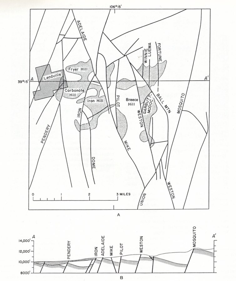
Most of the Leadville ore mined has come from an area bounded by Leadville on the west, the Ball Mountain fault on the east, Evans Gulch on the north, and Iowa Gulch on the south. Nevertheless, significant quantities have come from some outlying areas.
The primary ores at Leadville are of three types: (1) silicate-oxide deposits, (2) mixed-sulfide veins, mostly in siliceous rocks, and (3) sulfide replacement bodies in dolomite. Several periods of faulting prepared the way for introduction of the ore-forming solutions throughout the area.
The silicate-oxide deposits, of relatively minor economic significance, consist primarily of magnetite and hematite in a serpentine-manganosiderite gangue. Subsequent fracturing of this assemblage allowed the formation of gold-bearing pyrite veins.
The mixed-sulfide veins, most common in the eastern area because of the abundance of siliceous rocks there (which the veins seem to favor), consist of pyrite with interstitial chalcopyrite and gold in quartz gangue. Gold, silver and copper have been mined extensively from these deposits, particularly where the ore has undergone some secondary enrichment. In some areas the veins expand into sulfide replacement bodies.
The sulfide replacement deposits are more common in the western part of the district, where carbonate rocks suitable for replacement are more abundant. These bodies form mantos spreading out from fractures and sheeted zones under impermeable covers such as porphyry sills. The replacement ores consist primarily of sphalerite and galena with appreciable silver, all in a gangue of manganosiderite with quartz and barite. The most abundant sulfide was pyrite, its deposition beginning before and ending after the formation of sphalerite and galena. Only very small amounts of gold and silver are found in this ore; but considerable amounts of a different assemblage occur irregularly throughout the replacement bodies. This assemblage consists of chalcopyrite (most abundant), hessite (Ag2Te), altaite (PbTe), argentite, gold, and a peculiar silver-bismuth-rich variety of galena which is consistently near Pb11Ag11Bi11S15 in composition.
Replacement bodies occur all over the district, but those in the outlying areas tend to be smaller and simpler in their mineralogy.
Deposition in the Leadville area as a whole spans a range of temperatures and pressures. The magnetite-hematite ores are most certainly hypothermal; the high-grade replacement bodies appear to be mesothermal; the so-called bismuth-stage assemblage is a typical leptothermal suite; and deposits in the more distant areas are clearly telethermal.
Thompson et al. (1984) provides the most recent discussion of hydrothermal ore genesis at Leadville. However, DeVoto (1984) proposes some alternative concepts by theorizing that pre-existing karst (cavernous) topography within the limestone units controlled ore deposition in a manner similar to that associated with Mississippi Valley-type lead deposits.
About Some of The Mines
Considering that the Leadville area encompasses nearly 2000 mines, it would be impractical to discuss them all here. The following discussion touches upon some of the more interesting claims, with the understanding that there are many more stories left untold.
PRINTER BOY HILL
Printer Boy Hill Printer Boy Hill lies at the southernmost extension of the so-called Leadville gold belt. In this area gold mineralization seems to be closely related to bismuth mineralization (Loughlin and Behre, 1934, 1937). Both sulfide replacement and vein deposits occur in the area.
Printer Boy Mine
Locating specific information on many of the earliest mines is always extremely difficult, owing to the fact that no one at the time was especially interested in preserving for posterity any accounts of what actually happened. All energies were turned to producing precious metals and earning money, rather than to writing and recording.
Hardly any mine has presented such a challenge in research as the Printer Boy. Some few sources place its location in 1861 (Manning, 1895), while most say the date was 1868. Its low claim number certainly suggests the earlier date.
While it is true that the first discovery of gold in place was made at the Printer Boy in June, 1868, on the north side of Georgia Gulch by Messrs. Smith and Mullen, research suggests that it had been a claim long before that time and had been neglected for a while.
One source says that for a year very little attention was paid to the claim by anyone, and during the absence of the owners the claim was jumped and several thousand dollars in ore taken out. Attention of the owners was attracted and litigation ensued, bringing about the notice of the public (Raymond, 1872).
Since this mine, along with the Antioch, was opened to try to locate the source of the California Gulch gold, it appears odd that it would have been ignored for a while. If this occurred before 1868, however, when the lode was discovered, it surely might have taken place.
The notes of S. A. Safford, Surveyor, dated June 9, 1868, state that the claim contains “veins of ore from three to eighteen inches wide, composed of decomposed quartz containing some copper and very rich in free gold. The crevice usually carries a vein of dark gray cleavable talc on the west wall. Twenty-six ounces of gold have been taken from one pan of selected ore from this lode.” It was “worked by shafts and hand windlass, also by a tunnel” and the ore assayed at $75 per ton. At that time there was no mill (Bureau of Land Management files).
Eventually the float of yellow iron-stained clay was followed (after 1868) until it turned down into the formation in place, which proved to be the vein. A shaft was then sunk and discovery was made of a large body of ore. The vein was only about 50 cm wide and the ore consisted of decomposed porphyry, clay and iron, in walls of pyritiferous porphyry (Emmons, 1886; Lakes, 1895).
In 1880, Dill (1881) described the workings as primitive, unsafe and haphazard.
Ingham (1880) states that the claim proved to be valuable enough that a stamp mill was erected to crush its ore, and that the mill produced about $250,000 in bullion from 1868 until 1874. He also says that the mill “was not very successfully managed thereafter.” Monograph 12 asserts that the Printer Boy “produced a large amount of gold between 1866 and 1870, of which no record can be obtained” (Emmons, 1886).
Operated by the imperfect methods of that early period of mining, the Printer Boy produced, in the course of time, some extraordinary returns because the rich pockets lay comparatively near the surface (Hall, 1890; Griswold, 1951).
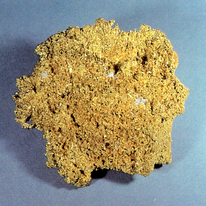
“Large bodies of decomposed quartz, soft and porous, were found, carrying great masses of free gold in nuggets, bunches of fantastically formed and matted wires, and beautiful crystallizations. Many large glass jars, such as are seen upon the shelves of drug-stores, were filled with these remarkable specimens, and exhibited, first at the national banks in Denver, and subsequently in Philadelphia and New York, where they excited much admiration, and for a time, revived the interest of speculators in the mines of Colorado” (Hall, 1890).
The Pilot fault divides Printer Boy Hill into two parts, and J. Marshall Paul is said to have made a fortune from the mine before finally selling the north half in 1868. Since that time it has been known as the Upper and Lower Printer Boy (Dill, 1881; Lakes, 1895).
Circa 1893, after sinking a shaft, running two drifts, and mining over $100,000 in value, a second shaft was started on the property. It was in this second shaft that two ore veins were found. From one of these “$4500 in gold nuggets were panned out from a single pan of dirt” (Dill, 1881); $4500 in gold computes to approximately 20 pounds troy of gold in a single pan, or about $74,000 at late 1984 prices! Nuggets of large size were taken from the mine, many exceeding 5 ounces, and one of 28 ounces (Dill, 1881).
“In the deeper workings considerable iron and copper pyrites and some galena and tennantite were found. Gold occurred in both pyrite and galena, and a piece of ore containing galena crystals, connected by a filament of wire gold, was one of the show specimens at the mine. Selected specimens are said to have contained 122 ounces of gold to the ton, and the average assay is given at three to four ounces” (Emmons, 1886).
In view of all the reports of fabulous finds, quite an exhaustive search has been conducted to locate specimens from the Printer Boy mine. To date no well-documented gold specimens have been found, after consulting the Harvard Mineralogical Museum, the Philadelphia Academy of Natural Sciences, the Smithsonian Institution, the Los Angeles County Museum of Natural History, the Denver Museum of Natural History, the Geology Museum at Colorado School of Mines and numerous private collectors. This leaves it open to conjecture as to whether or not the lavish reports were just a promotional scheme designed to encourage investment.
Lillian Mine
The Lilian mine carries one of Leadville’s most unusual mineral assemblages, in a sulfide replacement body. The mine is the discredited type locality for lillianite. But, in one of those peculiar twists of mineralogical history, even though the type specimens were discredited as mixtures, the species has remained valid. By coincidence, material matching the originally described (though erroneous) composition was subsequently found at the Sultan mine, Silverton district, Colorado, and in the White Cross-Hurricane Basin district, Colorado, so the species has been allowed to stand. The original author (Keller, 1889) therefore has the unique distinction of having described and named a valid species which he had never seen, at a time prior to its discovery.
CALIFORNIA GULCH
Rock Hill and Iron Hill are here included in the California Gulch area. Orebodies begin on Iron Hill, to the north, and pass under California Gulch to Rock Hill, on the south (Loughlin and Behre, 1947). The upper portions of California Gulch intersect the goldpyrite vein deposits radiating from Breece Hill and Printer Boy Hill. These were the veins which furnished most of the placer gold found in California Gulch in the early boom days.
The gulch is also the scene of the discovery of bonanza-grade silver-lead replacement bodies in limestone, where cerussite and chlorargyrite were the main ore minerals.
Many well-known mines from this area probably produced fine specimens, but the early-day Leadville mineral specimens have had a low survival rate. The best-known specimen producers include the Tucson mine, Moyer mine, and the A. Y. and Minnie mine.
Tuscon Mine
It seems very likely that the Tucson mine, patented in 1886 by Charles J. Doud et al. (Bureau of Land Management files) was one of the claims purchased by Stevens and Wood as they developed the carbonates on Iron Hill. The Tucson, along with the Luella, was added to the Iron Silver Mining Company of W. H. Stevens and Levi Z. Leiter in 1881, Leiter having purchased Wood’s interest (Dill, 1881; Ebbley, 1949; Blair, 1980).
In any event, the first operations were through the north and south incline by Stevens and Leiter, and the Tucson shaft was sunk to a depth of 338 meters (1,100 feet). At that time it was recognized as the best in the Leadville district (Ebbley, 1949).
In 1910 high-grade silver, one assay being as high as 2,000 ounces per ton, was mined in the lower levels. Considerable mining was carried on from 1912 to 1918, at which time lead and zinc sulfides were the main ores. A few attempts to reopen the mine between 1918 and 1926 were reported, but none was successful, and the property remained inactive until 1940 (Ebbley, 1949).
In that year the upper portion of the shaft was reopened by Axel Lind and Associates to gain access to a zinc carbonate (smithsonite) orebody known to have been left partly unmined by former operators. Production was discontinued after making five shipments of ore, because the minimum grade acceptable to the buyers was raised to 30% zinc. Low-grade lead carbonate (cerussite) ore was mined by the lessees and shipped to the local smelter until the mine was closed again in 1944 (Ebbley, 1949).
The upper workings of the Tucson mine intersect oxidized lead-silver ores in the Leadville limestone. A large specimen of jackstraw cerussite in the Colorado School of Mines collection is from this zone.
Many fine specimens have come from the Tucson mine. Chapman (1941) reports gold with hessite, altaite and galenobismutite. A material called “schapbachite” was found to be a mixture of hessite, bismuth-bearing altaite and gold; it occurred as a coating on 2.5-cm galena crystals.
A specimen of flattened galena crystals, apparently twinned on the spinel law, exists (ER collection); the crystals have a drusy gray coating (“schapbachite”?) and are associated with sphalerite and pyrite.
Fine, large, pyritohedral to octahedral masses of pyrite crystals have come from the Tucson mine, as well as siderite and botryoidal hemimorphite.
Vugs of twinned sphalerite crystals, some of which reached diameters of more than 1.2 cm and small well-developed crystals of arsenopyrite have also been reported (Emmons et al., 1927).
“An unusual occurrence of drusy and stalactitic galena was noted on the sixth level of the Tucson mine. This galena had grown upon zincblende crystals in vugs in sulfide ore along the hanging wall of the Tucson fault. The stalactites were as much as half an inch in length and were distinctly later than the blende or the few crystals of chalcopyrite that accompanied it. The galena was coated with a dusty film that may have been argentite, as the ore at this place assayed 80 ounces to the ton in silver” (Emmons et al., 1927).
Much of the sulfide material is associated with flattened rhombs of siderite.
Moyer Mine
Patent was granted on January 30, 1880, to William Moyer and Judge Wells for the Moyer placer, which they had located in 1877, under a special Act of Congress passed in 1872. Although it straddled California Gulch, it also extended up the south slope of Iron Hill (Silversparre, 1882; Denver Tribune, 1899 and 1902; newspaper, name unknown, 1888).
On February 24, 1880, the upper or northern portion was sold to Stevens and Leiter as part of the Iron Silver Mining Company and holdings grew steadily under several different managers.
The Report of the Director of the Mint tells of a new strike reported in 1882. “Near the porphyry, or top of the orebody, the mineral is a fair galena ore, carrying some sulphate of lead, and only small quantities of iron pyrites and zinc blende” (Burchard, 1884).
In 1890 some 2.5 km of drifts had been run in the Moyer alone (Harper, 1890). This included two shafts: the lower or south shaft sunk in 1882 (described in the above-mentioned Mint Report) and the north shaft, sunk sometime later approximately 800 meters to the north.
The Moyer mine shipped the first zinc to Belgium via Galveston, Texas, in 1899 (Blair, 1980) and thus in its own way was responsible for some of the beginnings of one of the later periods of Leadville – that of the lead-zinc-silver-gold, or composite, era.
Aside from good ore, the Moyer’s primary claim to fame is the multitude of ghosts which are said to inhabit it. Senator Gallagher of Silver Plume, who was killed in the mine, is said to have been seen wandering around, and the disembodied souls of twelve workers crushed to death in a cave-in have continued to occupy it (Blair, 1980).
The main ore shoot, a blanket-shaped sulfide orebody, measured 28 meters thick and 150 x 600 meters across (Emmons et al., 1927). Some of the Moyer orebodies were pure, solid pyrite which was ultimately mined as flux for the Leadville smelters. These orebodies were usually replaced limestone blocks completely surrounding intrusive porphyry. In places alternating bands of pyrite and sphalerite appear to have preserved original bedding structure. Another Moyer orebody was composed of mixed sulfides thoroughly shot through with secondary cerussite and limonite (Emmons et al., 1927).
The Moyer has produced lustrous, black, 2.5-cm sphalerite crystals on pyrite matrix (Henderson, 1926; Kosnar, 1976); hemimorphite; some very nice, although small (1.2-cm) modified crystals of galena; and some beautiful pyrite specimens showing combinations of the octahedron and pyritohedron (ER collection).
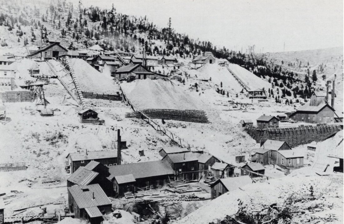
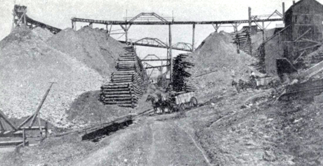
CARBONATE HILL
Carbonate Hill lies between the Pendery fault on the west and the Iron fault on the east. The Tucson-Maid reverse fault passes through the hill and appears to have been a factor in the development of sulfide replacement orebodies at the Wolftone mine.
The mines on Carbonate Hill were the second major group developed on secondary lead-silver bonanza deposits in the early days. As in the California Gulch area, the orebodies occur mainly in the upper Leadville limestone. Just below and sometimes adjacent to these orebodies lay the oxidized zinc ores for which the area is best known; these were not considered economical in the early days of mining and were temporarily bypassed.
Common botryoidal smithsonite was reported from the Maid of Erin mine (Loughlin, 1918), and other mines in the area reported fine smithsonite druses and mixtures with iron and manganese oxides. When the district finally did begin to produce zinc, the result was significant: $43,000,000 worth from 1910 to 1916, most of it from Carbonate Hill.
Wolftone Mine/A. M. W. Properties
The Wolftone mine, named for Theobald Wolfe Tone, the spiritual father of modern Irish nationalism, was located in 1876 by Samuel Morgan and Aden Alexander. Situated on Carbonate Hill, California district, 1.6 km (1 mile) from Leadville, five shafts were sunk ranging from 9 to 25 meters in depth and the ore was said to have a value of $250 per ton (Corbett, 1879).
Malta Smelting and Mining Company was the claimant requesting a survey in 1880; patent was granted later that year (Bureau of Land Management files).
“At a depth of 633 feet ore was first struck, and a body of iron pyrites, mixed with galena, passed through, which is 7 feet in thickness. It is not similar to other ores found on the hill, and is believed by those who have examined it to be an overlying iron body, and that the regular ore contact is at a still greater depth. … The strike is one of the most valuable ones made about Leadville for a year past, and will add large territory to the productive mines of this camp” (Burchard, 1882).
The A. M. W. Company, made up of the Adams, Maid of Erin and Wolftone mines, was organized sometime prior to 1892. The President and General Manager of the A. M. W. was S. D. Nicholson (Blair, 1980; Holmes, 1983).
When in 1910 the first highgrade zinc ore, reported as calamine (hemimorphite), was discovered in the May Queen mine, Nicholson began a search for oxidized zinc ores in the old workings of the Wolftone and discovered the largest body of zinc silicate in the district (Loughlin, 1918).
In 1913 Nicholson sent an unidentified sample of zinc ore to the Colorado School of Mines, where G. M. Butler identified it as a zinc-rich variety of aragonite and named it nicholsonite after the man who had brought it to his attention (Loughlin, 1918).
As the development of the oxidized zinc ores intensified, what was believed to be another new mineral species was found in the Wolftone and named wolftonite, but further study suggested it to be hetaerolite. In 1913 Ford and Bradley described it as a rare vugfilling mineral, found with a radiating mammillary structure, whose outer surfaces were generally smooth and rounded. More chemical analysis showed a quantity of water in the formula, indicating the mineral was actually hydrohetaerolite.
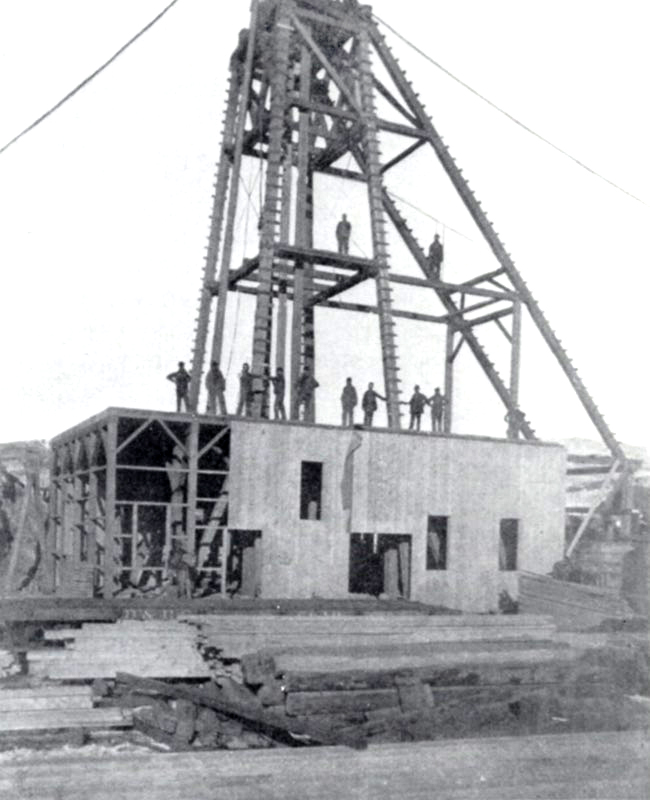
In 1920 the Wolftone mine had been developed by a shaft 1,120 feet deep, from which eight leads had been driven” (Hornor, 1920).
The Wolftone had produced hemimorphite, galena, sphalerite, and the other minerals already mentioned. Emmons et al. (1927) also reports “a considerable quantity of pyrite … with radiating structure suggestive of marcasite, but chemical tests proved it to be pyrite. The surfaces of many of the radiating pyrite crystals are coated with pyrite crystals of more ordinary form.”
Yak Tunnel
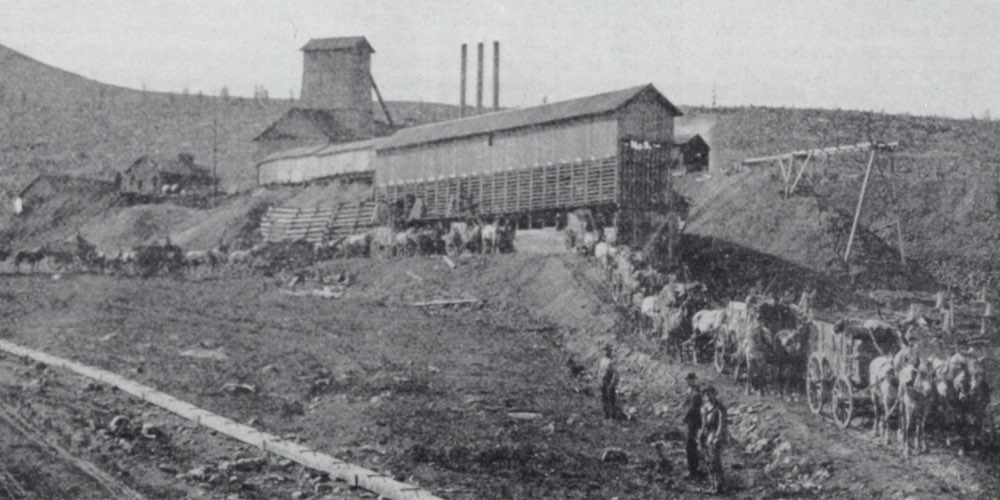
What has been and might still be considered one of the greatest undertakings in the Leadville camp is the development of the Yak tunnel.
In 1899, A. A. Blow, general manager of the Silver Cord Combination Mining Company, was instrumental in the construction of a tunnel. Its portal is on the south side of Carbonate Hill, about 1.2 km southeast of the Leadville city limits, halfway between Leadville and the former site of the most recent Oro City settlement.
The Blow tunnel, as it was first called, was planned to reach the Silver Cord incline and was to be used for draining the mine and as a haulage-way. Human power was the force behind the first haulage, but when the distance from the face to the portal made this impractical, mules came into use. By June 24, 1892, a distance of 910 meters (2956 feet) to the Imes station of the Silver Cord incline had been completed (Luke, 1971).
The tunnel had penetrated 1.2 km to the Colonel Sellers mine when the repeal of the Sherman Silver Act brought about cessation of the work in 1893.
Shortly after shutdown the two-year-old mill burned, causing Blow to recommend the formation of a new company for the purpose of driving the tunnel through Iron Hill to the area beneath Breece Hill (Luke, 1971). It was felt that the mines on Breece Hill, including the Ibex properties, could be unwatered and worked more effectively through a tunnel. In addition, there would no doubt be exposed a number of exciting prospects along the tunnel’s route (Blair, 1980).
As a result, the Yak Mining, Milling and Tunneling Company was organized. In addition to Blow and other individuals, one of the organizers was John F. Campion. The Yak name probably was chosen by Campion, who named properties for large hoofed animals (Luke, 1971).
Work on the new project began in March, 1895, and by the end of 1899 the tunnel had been driven 2.5 km to a depth of 400 meters below the Forest Queen on Breece Hill (Luke, 1971).
At the turn of the century attention shifted from gold and silver to increasing amounts of lead-zinc ore, with over 1000 tons per year being shipped by way of the Yak. It was at this time that consideration was given to continuing the tunnel under the Mosquito Range and emerging into Park County (Luke, 1971). However, this plan never came to fruition.
The Yak workings reached the Resurrection #1 mine in 1908. By January 1, 1909, it extended 4.8 km into the hills, and October 30 of that year saw the Resurrection #2 included in the networks of laterals, shafts and raises. During this time the work continued to the accompaniment of numerous improvements, including electric locomotives, a new electric generating plant and a new magnetic separator mill (Luke, 1971).
The terminus of the Yak was reached in October of 1912, approximately 6.4 km (4 miles) from daylight, “in the vicinity of the Diamond and Vega properties, approximately one mile northwest of Little Ellen Hill” (Luke, 1971).
Mines all along the route of the Yak were unwatered, a benefit for which owners paid the Yak Mining, Milling and Tunnel Company. “Many of the mines along the route were worked through the tunnel and for that privilege they also paid. The Company owned a considerable number of claims outright; others they leased and paid royalty on; still others were held in ‘perpetual contract,’ which gave the Yak an easement through the property and allowed the owner to work his own mine if he desired” (Blair, 1980). Of course, there were fees and royalties charged for this privilege, also.
In 1917 ASARCO purchased an undivided half interest in the Yak, but activity slowed drastically after World War I and through the depression of the 1930s. Abandoned workings filled with water; some have never been pumped dry. In 1938 Newmont Mining Corporation and Hecla Mining Company purchased interests and joined ASARCO in the Resurrection Mining Company, which included the Yak properties (Luke, 1971).
Production flourished during World War II, but slowed considerably afterward. A fire in 1956 destroyed most of the surface facilities of the Resurrection, resulting in a mine shut-down in 1957. ASARCO’s smelter closed in 1961, and in 1963 the tracks to the portal of the Yak were removed.
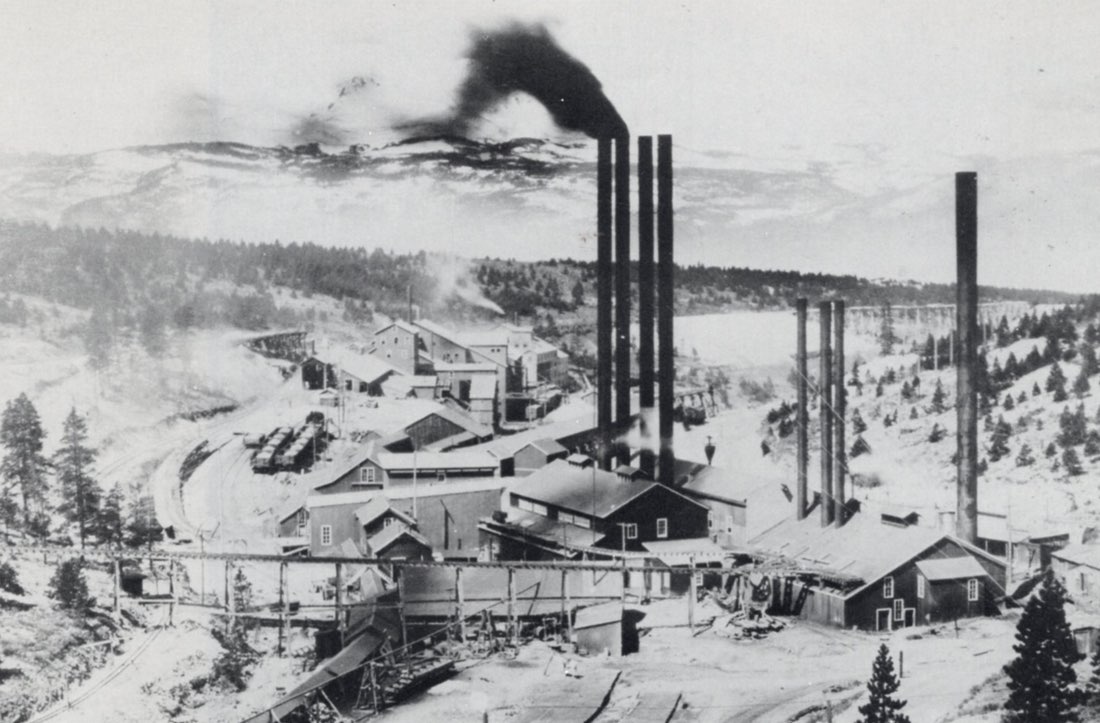
The Yak tunnel provided its owners with a steady income for nearly half a century, and it was still a part of local mining operations in 1980. It enabled several marginal properties to operate profitably by lowering overhead costs; it provided drainage, transportation and ventilation to numerous mines; it extended the growth and production of the Leadville district for many years (Blair, 1980). By 1971, only the Black Cloud mine (ASARCO) maintained access to the Yak; all other operations had ceased.
It is difficult to say for certain where mineral specimens marked “The Yak” came from. Specimens could have originated in the Silver Cord, which consisted of “vuggy veinlets of pyrite and quartz cementing the quartzite fragments and partly replacing them, practically pure pyrite to practically pure zinc blends (or sphalerite), and barite in small crystals” (Emmons et al., 1927). They might also have come from any of the mines worked through the 6.4 km of the tunnel system. Well-formed galena crystals have also been labeled “The Yak.”
FRYER HILL
Fryer Hill is easily the most famous of the early lead-silver bonanzas. Orebodies were found in the anticline under the hill, and in the syncline under adjacent Fairview Hill. Mineralization was so intense that virtually all of the upper Leadville limestone became replaced by sulfides.
The oxidized lead-silver ores on Fryer Hill consisted predominantly of remnant galena with cerussite and minor anglesite and pyromorphite, chlorargyrite and iodargyrite (Emmons, 1886).
The first secondary zinc ore (smithsonite) produced in all of Leadville came from the Robert E. Lee mine on Fryer Hill; though no detailed description of the ore has come down to us, it was probably similar to Carbonate Hill material.
The Matchless Mine
According to Gordon L. Hall in his Two Lives of Baby Doe, the Matchless was discovered on Fryer Hill in July, 1878, by seven poor prospectors and named for Lorillard’s chewing tobacco. A year later a survey was granted to Tim Foley, A. P. Moore and T. B. Wilgus. Although they extracted a considerable amount of ore from the mine, they had no idea of the riches it contained (Dill, 1881).
The mine was patented in 1879 (Colorado State Mining Directory, 1898), and H. A. W. Tabor in September of that year “claimed he wanted a mine to call his own,” after being involved very profitably in a number of other mining ventures, “and spent $117,000 to clean up the various lawsuits against the property” (Blair, 1980).
Of three shafts on the property, only one with a small vein of galena ore showed promise. The shaft was sunk to a depth of 77 meters (250 feet) when it became flooded and work was soon halted (Dill, 1881). Lou Leonard took over as Mr. Tabor’s manager in July, 1880, and reopened the mine (Blair, 1980). A new shaft was sunk to “a depth of 148 feet, and from this a drift 42 feet long has been run. . . . (L)ater yesterday afternoon a fine body of (silver) chlorides . . . was struck. It is 8 feet high and 10 feet were passed through. The chlorides were mixed with flint and iron, and will run high in the thousands. An assay was made from some of the ore late this afternoon resulting in 1,434 ounces in silver to the ton” (The Denver Tribune, November 25, 1880).
Mr. Tabor was realizing a net profit from the Matchless mine of over $2000 per day by 1881 (Dill, 1881).
United States Mint Reports for 1882 stated of the Matchless: “The ore is for the most part chloride, crystalline particles of which are studded all through the masses of ore, and sometimes specimens are obtained which assay many thousands of ounces.”
In 1888 another rich vein was struck, assaying 125 ounces of silver per ton (Colorado Graphic, n.d.).
“It was leased about 1918 by Dr. Bailey; again in 1937 by Tom Palmer,” who turned it into “Leadville’s major attraction. It is the Mecca which is daily attracting tourists, scores of cars carrying visitors from every state in the Union to the cabin that has now become almost a shrine. . . . (T)he visitor can select his specimen of argentiferous iron,” and Tom “impressed the visitors with the belief that a fortune, coy and concealed, still lurked within the depths of the old mine.” Tom arrived in town with a lease from the Shorego Mining Company “just when the cabin was becoming the prey to the pillagers” and restored the place. “It seems to be Tom Palmer’s ambition to make a mine out of the Matchless. He has at least made it Leadville’s most popular showplace” (Carbonate Weekly Chronicle, August 16, 1937).
“In 1964 the owner was (still) Shorego Mining Company, Denver” (Gilfillan, 1964), “which is in turn owned by the heirs of J. K. Mullen, who was a contemporary of the Tabors” (The Rocky Mountain News, May 28, 1969).
This mine, situated on Fryer Hill in Little Stray Horse Gulch, adjoining the Robert E. Lee, California district (Colorado State Mining Directory, 1883; Burchard, 1883), produced some very fine wire silver with pink rhodochrosite (Miller, 1971). Pyrite, galena, sphalerite, cerussite and siderite have also been reported (Muntyan, 1979).
One of the Matchless silver orebodies had the peculiar distinction of being almost entire lead-free, and consisted of finely disseminated chlorargyrite in a sandy-textured ocherous mass.
BREECE HILL
Breece Hill is the center of the main intrusive complex at Leadville. Both vein deposits and replacement orebodies exhibit some zoning concentric to Breece Hill. Over 100 precious metal-pyritequartz veins have been discovered extending outward from the complex. Pyrite-gold ores occur in fault breccias, and tungsten mineralization is also present (Behre, 1953; Loughlin and Behre, 1947).
Contact-related magnetite-serpentine-carbonate skarns formed during the intrusion of the Breece Hill stock, and magnetite was mined from these in the 1880s to the 1920s as a smelter flux. Most of this production came from the Penn mines and carried small values of gold and silver in zones where pyrite and chalcopyrite had replaced magnetite (Thompson et al., 1984).
Lead isotope studies suggest that convection cells of circulating meteoric water leached metals and sulfur from the Breece Hill stock and redeposited them in faults and as replacements in limestone (Thompson et al., 1984).
The Little Jonny/Ibex Mine
The Little Jonny is another mine of the California district whose beginnings are somewhat uncertain.
One story is that in the winter of 1879 three young men – John Curran, Thomas Kelly and James H. Donovan – left Galena, Illinois, and went to Leadville, where they dug away 2 meters of snow on Breece Hill to put up a cabin. In this they lived and starved all winter. Kelly died from illness brought on by exposure and privation, and was soon followed by Curran, after whom the mine was named. They knew nothing about mining and had located their claim in haphazard fashion. Kelly’s heirs are said to have sold their interest for $1000 and the Currans for $2500. The amount Donovan received is unknown (The Denver Times, February 19, 1899; Blair, 1980).
Another source indicated the Little Jonny was surveyed August 21, 1879, for A. F. Ozmond et al. (Bureau of Land Management files).
Of course, Hollywood has erroneously insisted that Leadville Johnny Brown located it for his wife, the Unsinkable Molly Brown.
John Campion, who was so prominent in developing the Ibex properties, came to Leadville in 1879 and did quite well buying and selling claims. After a short period of time, he had amassed enough capital to begin working the properties, instead of continuing to trade them. This enabled him to organize the Elk Consolidated Mining Company, when he inaugurated his practice of naming properties for cloven-hoofed animals, and shortly thereafter he “took a lease on the Little Jonny, which had been abandoned after Captain Jack McCarthy had sunk 159 feet to the sulfides, which were then worthless” (Dawson Scrapbooks; Blair, 1980).
Eventually Campion and his associates were able to purchase the Little Jonny and a number of adjacent claims. In 1891 the Ibex Mining Company was formed under Colorado laws as a closelyheld corporation. It owned 150 acres of land on Breece Hill and was comprised of a consolidation of the Little Jonny, Uncle Sam, Archer and Titan claims, and the old Glengarry and Queen consolidations (Canfield, 1893; Manning, 1895).
Soon after Campion’s arrival in Leadville, James Joseph Brown reached Colorado. Following a short stay in Denver and a period of working the mines in Aspen, Alma, Fairplay and other camps, Brown moved to Leadville and got a job at the Maid and Henriett mines. By 1893 he had gained enough experience that he was made superintendent of the Ibex properties. Because of Brown’s assistance in solving the problem of caving dolomite sand and his general work as superintendent, the owners gave him 12,500 shares of Ibex stock (Blair, 1980), which may have amounted to as much as three-sixteenths interest in the Ibex Company (Coquoz, 1965).
“During Campion’s days, miners found the ‘golden stairs’ and ‘millionaire’s chamber on the third level between Numbers 1 and 2 shafts of the Ibex (Number 1 was the Little Jonny). The stairs – a step fault – had wire and sheet gold; the chamber – a cave – was similarly inlaid. “It (the gold) could be pried off with a chisel or screwdriver,’ said one observer” (Gilfillan, 1964).
Emmons (1927) describes another find as follows: “Wire and leaf gold occurred very abundantly in a seam of sulfide which was found on the sixth level of the Ibex about 200 feet south of the Big Four shaft and which was associated with certain highly siliceous ores interbedded with black ‘Weber shales.’ Some of the richest ore found in the Ibex mine was taken from this locality. The oxidized siliceous ore in one of the stopes above the third level of the same mine contained a small but remarkably rich seam of leaf and wire gold mingled with decomposed silicified porphyry. Sixteen sacks mined from this seam carried more than 50 percent of gold. In a specimen from this locality, seen in the office of the Ibex Mining Co., the gold occurs in a seam of compact jasperoid between limestone and porphyry. The jasperoid is stained deep brown by iron, has a conchoidal fracture, and contains sheets of gold in the joints. Some of these sheets are from 1 to 2 inches across. The gold is pure yellow and 860 fine. Another specimen in the company’s office, from the sixth level of the Ibex mine, shows a large cluster of zinc blende and pyrite crystals which form a coating half an inch thick on a quartz seam. The quartz, partly stained by oxidation, shows many irregular openings which contain free gold, mostly in long wires but partly in leaf-like plates.”
Native gold was also found in the oxidized zone in some of the lodes penetrating porphyry. In the Number 7 vein of the Ibex mine, on the tenth level, at the junction of the oxidized and the sulfide ores, it was discovered as thin leaves on sheeting planes in the porphyry (Emmons et al., 1927).
In the ornate prose of Arthur Lakes (1895), writing on the collection of the Colorado State Mining Bureau exhibited in the Capitol building: “A specimen from the Little Johnnie [sic] mine, Leadville, is like a number of golden caterpillars or snakes crawling out from a mass of brown moss of iron oxide. This free gold is not always a pure, bright, golden yellow. Sometimes it is so tarnished or covered with rust that it might readily be taken for blotches of yellow ochre or common mud.”
Gold was also reported to have occurred in much of the ore containing considerable sphalerite. In the early days a specimen of ore in the office of the Ibex Company contained crystals of sphalerite coated with films of gold (Emmons et al., 1927).
It was also during Campion’s time that a solid mass of copper ore 3.7 meters (12 feet) in thickness was found (Dill, 1881). This yielded some large, well-crystallized sprays from the fifth level (Emmons et al., 1927).
In 1914 and 1915 another type of orebody was recognized and studied by the U.S. Geological Survey. It was one of gold-bearing quartz-pyrite veins containing the tungsten minerals wolframite and scheelite. This ore was primarily from Ibex properties and adjoining properties on the south and east sides of Breece Hill (Fitch, 1916).
Between 1894 and 1922 the Little Jonny produced close to $50,000,000, with a net profit of $12,000,000. Ore ran from $15 per ton in gold and copper values, to $60 per pound in the gold vugs (unknown newspaper, December 3, 1922). In 1925, Ibex workings aggregated 80 km (50 miles) and in 1938 they produced about 300 tons per month (Gilfillan, 1964).
On the south side of the Ibex properties quartz occurred mostly in typical colorless crystals up to 5 cm in length, which lined cavities and also penetrated pyrite crystals. Pyrite was well-distributed throughout the veins, occurring mostly in groups of rather large crystals. Single crystals of cube form were found with edges 12.7 cm long. An interesting phase of the pyrite crystals was the repeated development of narrow pyritohedron faces on a large cube face giving, especially where corroded, a “Gothic window” shape of marking (Fitch, 1916; Emmons et al., 1927).
In addition to the aforementioned gold and scheelite specimens the Ibex group has also produced good black sphalerite crystals. Fine specimens of vivianite have also been found; one specimen which can be seen in the Denver Museum of Natural History consists of 5-cm blue-purple vivianite crystals on matrix. Emmons et al. (1927) note vivianite also occurred as solid aggregates, single crystals and crystalline druses lining cavities on masses embedded in loose infiltrated clay.
Dull brownish black masses of wolframite occurred in the South Ibex stockwork. “These masses contain many small cavities, where some faces and angles of wolframite crystals have developed, but these are generally so corroded that no adequate idea of the crystal form can be gained. In one specimen, however, there is an isolated crystal over half an inch long, projecting into a small vug” (Emmons et al., 1927).
In addition to those mentioned above, several other interesting species were found in the Ibex mine. Jackstraw cerussite, chlorargyrite, minium intergrown with cerussite, hemimorphite, vivianite in fine prismatic crystals (some to 8 cm), pyromorphite, and Leadville’s only occurrence of aurichalcite.
The central portion of the No. 4 vein was the location of huge pyrite cubes measuring 15 to 25 cm on an edge (Holmes and Kennedy, 1983). Many fine gold wires and leaves were also found there.
All of the Ibex veins connect with sulfide replacement bodies and were most likely the solution channels which fed the replacements (Emmons et al., 1927).
Garbutt Mine
The Garbutt vein fills the Garbutt fault, with intrusive porphyry on one wall and Cambrian shale on the other; no limestone or dolomite are intersected. Also within the mine is the South Ibex stockwork, found on the second level about 8 meters from the Ibex No. 4 vein. Here quartz has been found in crystals to 5 cm, along with large pyrite cubes to 12 cm on an edge. Wolframite and scheelite occur irregularly scattered in vugs. Crystals of scheelite are deep red-orange dipyramids occasionally reaching 1 cm on an edge (ER collection). Wolframite and pyrite have been observed as pseudomorphs after scheelite (Emmons et al., 1927).
IOWA GULCH
The Black Cloud Shaft
The Black Cloud shaft on the north side of Iowa Gulch that most know of today takes its name from the original Black Cloud lode claim. Smith (1983) indicates this original lode claim was staked by R. D. Elder, while Silversparre (1882) points out that claim survey number 903, Black Cloud, was granted to R. W. Officer, et al. in 1880 (Bureau of Land Management files).
In 1880 a Philadelphia merchant and tailor spent $5000 in meeting notes of a friend and business associate. In this fashion Meyer Guggenheim became half owner of the A. Y. mine, and subsequently he and his partner bought the Minnie mine. This modest beginning eventually led to the Guggenheims’ involvement in the American Smelting and Refining Company (now ASARCO, Inc.), which in time came to own the Black Cloud mine (Blair, 1980).
As early as 1927, Emmons, Irving and Loughlin had alluded to the possibility that replacement ore might be found in a downdropped block of ground bordered by the Ball Mountain, Weston and Garbutt faults. From this date extensive evaluation was carried on in this area.
In 1942 W. R. Landwehr reviewed the Leadville district for geologically favorable ground which might be leasable. Findings in 1968 revealed an ore reserve of 2,080,410 tons averaging 0.089 ounces gold, 2.48 ounces silver, 5.05% lead, 9.42% zinc and 0.19% copper.
As a result a new shaft was sunk on R. D. Elder’s old Black Cloud lode and it became a producing mine in April, 1971 (Smith, 1983).
“In 1973, the Black Cloud shaft produced 11,350 ounces of gold, ranking third in the state for gold production. It was second in lead production and sixth in silver production” (Holmes, 1983).
The Black Cloud has produced nice specimens of splendent black sphalerite crystals sprinkled with 6-mm galena cubes, other galena crystals to 2.5 cm, white dolomite crystals on black sphalerite, wurtzite on stalactitic dolomite, golden barite, galena, and Japanlaw twinned quartz crystals (Kosnar and Miller, 1976; Muntyan, 1979; Holmes and Kennedy, 1983). Also reported from the Black Cloud are pyrite, siderite, cerussite, small blue (!) quartz crystals to 4 mm, and rare greenish barite crystals to over 3 cm.
The Julia-Fisk Mine
The Jim Fisk claim was located in 1880 and patented in 1881 by Raphael Marcott (Bureau of Land Management files; Corregan, 1883), and the Little Julia was patented by Joseph Frazer et al. in 1881 (Bureau of Land Management files).
It is unclear just how it came about, but it was decided to locate the first shaft of the Julia-Fisk mine at the southernmost tip of the Fisk claim, on the north slope of Iowa Gulch and the east slope of Printer Boy Hill, about 150 meters from a shaft near the north end of the adjacent First National claim. Eventually the claims became part of the First National Gold Mining and Leasing Company, which was formed to sink the shafts deeper in order to locate a second and richer contact. Mining in the Julia-Fisk was carried on chiefly between 1900 and 1910, when the shaft was sunk to 185 meters (Manning, 1895; Behre, 1953).
At a depth of 126 meters a small bedding plane deposit of silverbearing galena was found between quartzite and Dyer dolomite, and ore valued at $20 a ton was mined; “near the bottom of the shaft a gold-bearing fissure was discovered, assaying 1.0 ounce gold and 40 to 50 ounces silver to the ton, but organizational difficulties and heavy pumping costs compelled the company to stop operations” (Behre, 1953). Although the shaft was reopened in 1957, a decline in metal prices curtailed most activity (Holmes and Kennedy, 1983).
Most of the recent activity in this area centers around the Black Cloud shaft, which has intersected some of the Julia-Fisk orebody, as well as other orebodies in the general area.
“The large dump in 1932 yielded many specimens of primary minerals, including galena, dark brown sphalerite, a little chalcopyrite and considerable manganoan siderite. Most of this siderite occurs as very thin rhombohedrons forming rosettes, under which arsenopyrite commonly appears in short prisms up to 1 mm in length” (Behre, 1953). Also “pale pink (rhodochrosite) scalenohedra about one-quarter inch long” have been found (Miller, 1971).
HORSESHOE AREA
The Horseshoe area, sometimes called East Leadville, is on the eastern frontier of the Leadville district about 11 km (7 miles) from the town of Leadville. Although the area is separated from Leadville by a high range of peaks, the geology was long thought to be identical (Leadville Lead Corporation, 1947). Thompson et al. (1984) point out, however, that the circumstances are quite distinctive; the orebodies appear to be confined to sediment filled karst paleotopographic features underlying shale beds in the Leadville limestone, and also to a few small faults. Silver values come from tetrahedrite and minor acanthite.
Sherman Tunnel/Hilltop Mine
Although the Hilltop mine is actually in Park County, many, if not all, of its mineral specimens arrived through the Sherman tunnel in Lake County.
The Hilltop mine actually saw its beginnings with the staking of the Last Chance claim in 1869. Progress on the claim continued during the ensuing years and in 1877 the Last Chance was supplying ore to a new smelter erected at the town of Horseshoe, about 9.6 km to the east. The mill was apparently unsuccessful; in 1884 the Last Chance began shipping ore to Fairplay and construction was started on a mill at a site that was later to become the town of Leavick (Leadville Lead Corporation, 1947).
In 1886 a mine cook, discharged by Last Chance operators, located three claims – the Hilltop, the Ptarmigan and the Leslie De; these were just north of the Last Chance endline and represented the beginning of the Hilltop mine. The Hilltop Incline shaft, sunk to a depth of 37 meters, resulted in highly profitable production (Leadville Lead Corporation, 1947).
“The Hilltop produced heavily and profitably from 1886 to the silver decline of 1893” (Leadville Lead Corporation, 1947). Felix Leavick and associates acquired control in 1892. Immediately they built a narrow gauge railway spur from Fairplay to Leavick and constructed a 5-km aerial tramway from Leavick to the main Hilltop shaft. In light of these large expenditures, the silver price drop of 1893 was disastrous to the Leavick group and operations were suspended.
A number of different lessees operated the mine from 1893 to 1923 with varying degrees of success. “A drop in the price of silver occurred in 1923 with the expiration of the Pittman Silver Purchase Act, and essentially all mining activity in the Horseshoe district was terminated for a period of around twenty years” (Bloom, 1965).
The Horseshoe Zinc Company started work in the area when in 1943 it leased the mine claims of the Hilltop group and in 1945, after consolidating properties in the Four Mile Amphitheater, the company was reorganized to form the Leadville Lead Corporation.
In 1946 this corporation started driving the Sherman tunnel on the side of Mount Sherman and planned to go under the old Hilltop workings to evaluate lower level veins (Leadville Lead Corporation, 1947). From this tunnel and the Hilltop workings have come a variety of fine collectible mineral specimens.
Plates of small hemimorphite crystals, crystalline quartz and white mamillary smithsonite have come from the Hilltop.
The Sherman tunnel has produced large, thick, golden barite crystals up to 5 cm on an edge, hemimorphtie, crystalline azurite and malachite, calcite, smithsonite and native silver.
Minerals
The following discussion centers on those species of most collector interest. All of the species reported from Leadville are listed on Table 2, and a few are also described in the preceding section on mines.
Aragonite
(Ca,ZN)CO3
A variety, named nicholsonite and containing up to 10% zinc, was found at the Wolftone mine (q.v.) It was typically found as diverging or spherical radiating crystal aggregates having individual crystals to 2.5 cm in length (Butler, 1913; Loughlin, 1918).
Barite
BaSO4
“Some white crystals in vugs in sulfide ore supposedly were found in the Yak tunnel” (Emmons et al., 1927).
Calcite
CaCO3
“Large and very handsome rhombohedrons (of calcite) on cerussite occur in the Evening Star. Much of it occurred in a cave found in the workings of the Boarding-house shaft” (Ricketts, 1883).
Cerusite
PbCO3
“Large and very handsome rhombohedrons (of calcite) on cerussite occur in the Evening Star. Much of it occurred in a cave found in the workings of the Boarding-house shaft” (Ricketts, 1883). “There are few mines in the Leadville district which do not contain at least a small portion of this mineral in their oxidized ores, especially the iron and manganese oxides, in which the crystals may be visible or may be detected only by chemical analysis. Cerussite occurs in three well-recognized forms – as large crystals; as aggregates of small crystals, generally loosely bound together and known as sand carbonate; and irregularly disseminated in masses of dense silica, which are usually termed hard carbonate. The large crystals of cerussite are found either embedded in manganese and iron oxides or in clay, and occur at many places as radiating clusters or as drusy linings in cavities in the harder ores. Some crystals are white and glassy; others are discolored by minute inclusions of darker minerals, some of which have been proved to be the silver sulfide argentite. Occasionally minute crystalline specks of silver chloride are found coating the crystals of cerussite. It has been shown by many assays and analyses of the Leadville cerussite that this mineral always carries a little silver, which is generally believed to be present either in the form of minute argentite inclusions or minute scattered specks of silver chloride or bromide” (Emmons et al., 1927).
A fist-size chunk of jackstraw cerussite is known [ER collection] in which crystals 1 mm by 1.5 cm are complexly intergrown. The specimen is from the Stone mine, one of Wood’s and Stevens’s original 1874-75 claims in California Gulch.
“It is reported that in the Morning Star and Evening Star mines there were numerous cavities in the galena which were lined with large transparent crystals of cerussite having the form of long prisms capped by the pyramid” (Emmons et al., 1927).
Copper
Cu
Flat, dendritic masses of copper occurred in the Ibex mine and as small thin flakes in the mines on Iron Hill. Although occasionally found in other localities, none was of sufficient size or form to collect (Emmons et al., 1927).
Dolomite
CaMg(CO3)2
Dolomite occurred “as white rhombohedrons lining vugs in sulfides” in many of the mines of the area (Emmons et al., 1927).
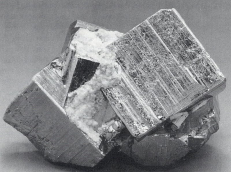
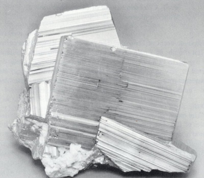
Galena
PbS
“Galena occurs mostly in granular masses, and to a minor extent as well-developed crystals lining cavities. . . . Where the galena is pure the largest crystals attain an inch in diameter.
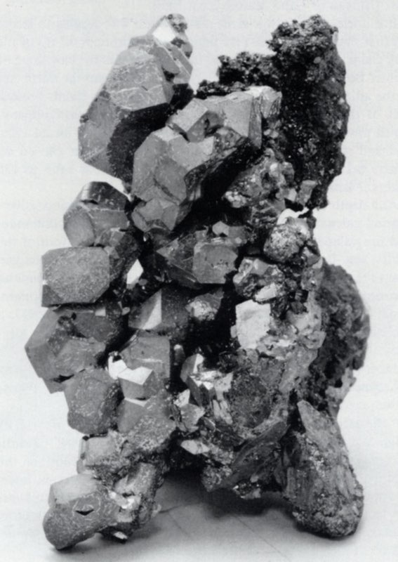
“Large fractures lined with galena crystals were observed in the Moyer, Tucson, A. Y. and Minnie, Wolftone and many other mines.
“Another variety of galena in peculiar crystal form occurs in considerable quantity in nearly all the mines, and is especially abundant in the mines of Iron and Carbonate hills and Graham Park. These crystals are brilliant and in places occur in great profusion as linings in the cavities of the ores. Many of the cubes are twinned, and some of the faces are built up by peculiar rounded irregular and incomplete accretions. Many of these accretions consist of smaller and smaller superposed layers. These layers are similar in origin to those giving the ‘Gothic window effect to pyrite crystals. Some portions of the crystals, usually on the under sides next to the wall on which they are attached, are rounded and irregular, resembling semi-fused material. This appearance is not due to fusion, however, but may be interpreted as a variation of the accretionary growth just described, in which the decreasing size of the successive layers is so gradual that no lines of division can be seen between them” (Emmons et al., 1927).
Some galena contains silver and bismuth (Chapman and Stephens, 1933).
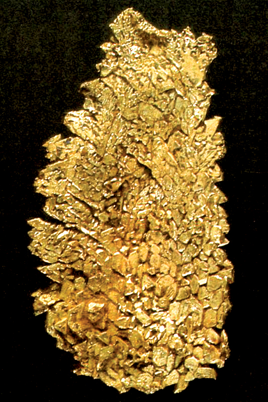
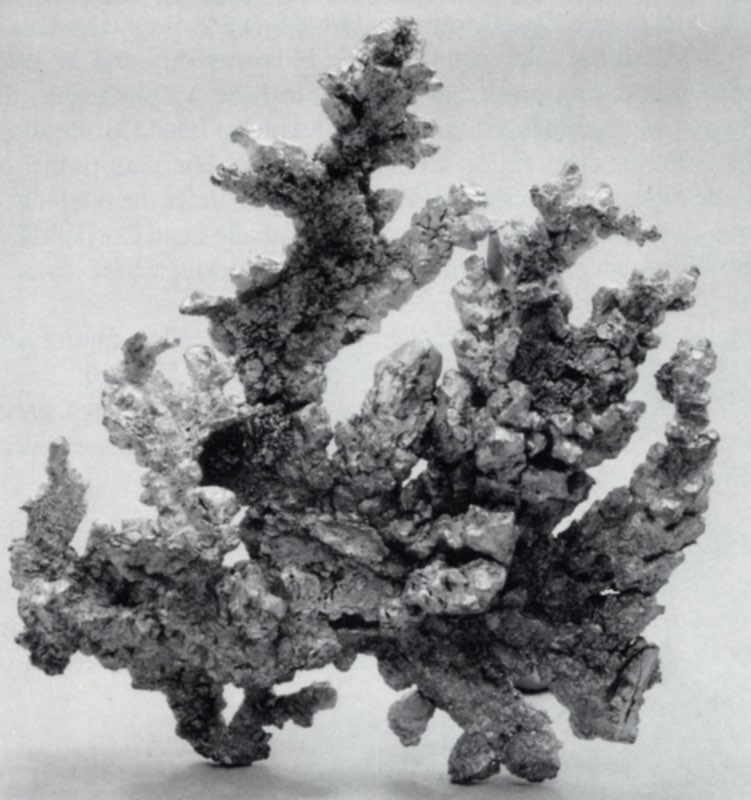
Gold
Au
“Native gold has been found in varying quantity in many of the Leadville ores. Although most of the ore classed as gold-silver or gold-copper ore, whether primary or altered, contains gold only in microscopic or submicroscopic grains, gold in coarse flakes and wires has been seen in the enriched parts of several of the lodes and closely associated blanket orebodies in the eastern part of the district, notably in the Ibex, Garbutt, Winnie-Leuma, Big Four, Colorado Prince, Great Hope, Printer Boy and Lilian (Florence) mines” (Emmons et al., 1927).
In the Winnie-Leuma lode “some of the ore ran as high as 100 ounces to the ton in gold, and leaf and wire gold occurred in considerable quantity. The blanket ores of the Florence (Lilian) mine carried large quantities of native leaf gold on a narrow contact between the limestone and the overlying white porphyry.” Specimens of crystalline gold composed entirely of flattened octahedrons in parallel growth, associated with alaskaite (a discredited species) were reported (Emmons et al., 1927).
Hemimorphite
Zn4Si2O7(OH)2·H2O
According to Heistand, the Henriett and Maid of Erin mines produced specimens of hemimorphite (Heistand, n.d.).
“Calamine (hemimorphite) occurs typically in fine to coarse druses of white to colorless bladed crystals, or in aggregates of diverging crystal groups, which may partly or completely fill cavities. In one exceptional specimen, found … on the dump at the Adams shaft, . . . calamine crystals are coated with minute quartz crystals. The calamine crystals have grown upon both massive and drusy smithsonite and on red and brown iron oxides and black manganese oxides” (Emmons et al., 1927).
The Field Columbian Museum of Chicago reports that some Maid of Erin ores received after the World’s Columbian Exposition in 1893 contained an ocherous substance thickly coated with long, slender crystals. The crystals, determined by testing to be calamine or hemimorphite, occur in groups which were partly radiated and partly joined. The average length of the crystals is about 10 mm; they are transparent to translucent and colorless to white (Farrington and Tillotson, 1908).
In the Little Jonny hemimorphite crystals were found as diverging groups of blades associated with Leadville’s only occurrence of aurichalcite.
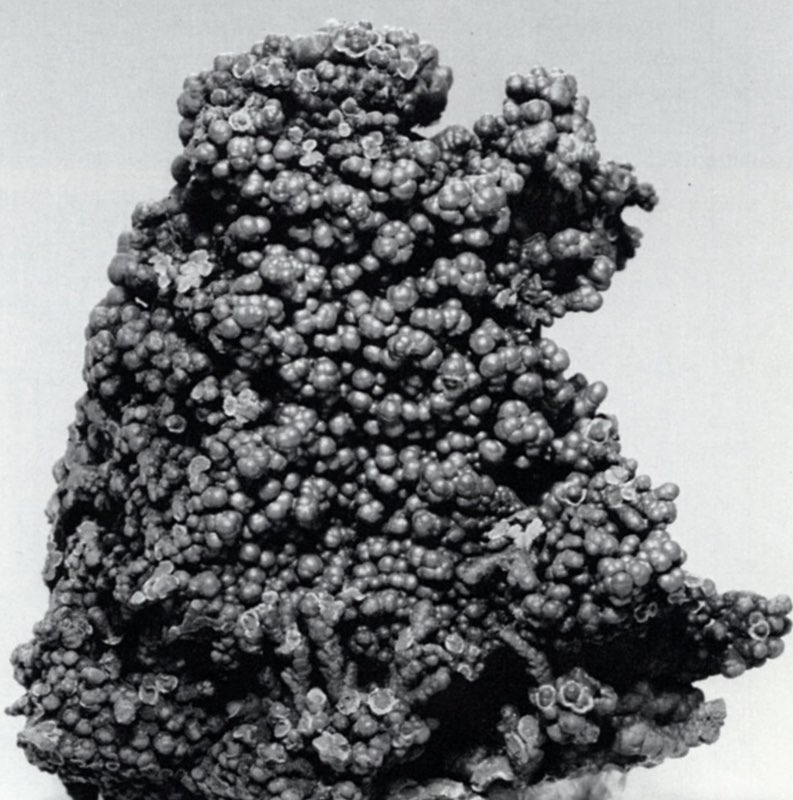
Psilomelane
Mn oxides
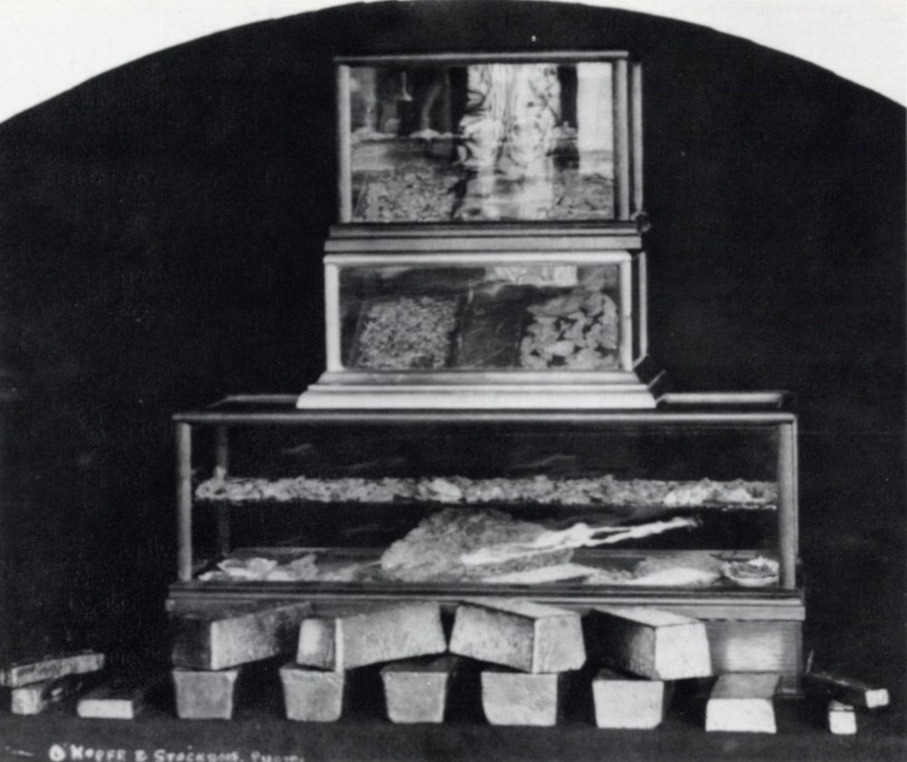
Manganese oxides (“psilomelane”) occurred in both stalactitic and mammillary forms and one fine specimen can be seen in the accompanying photographs. Unfortunately, the only locality given is “Leadville.”
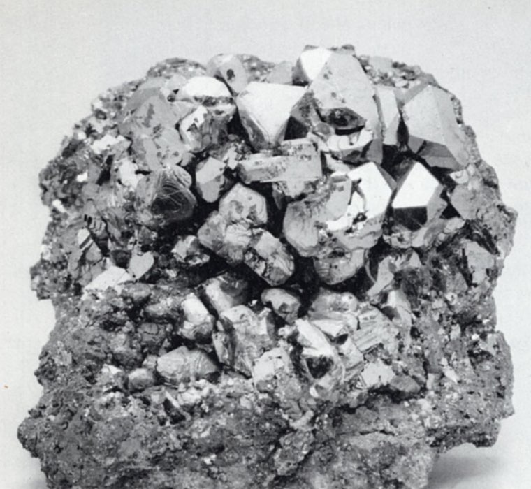
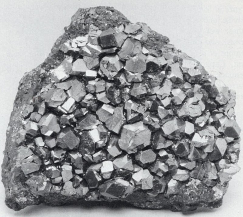
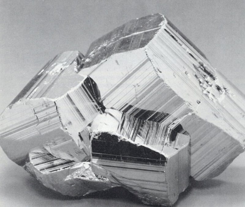
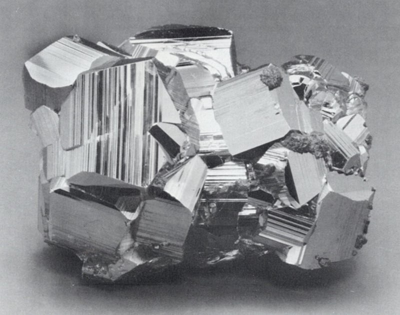
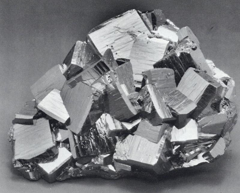
Pyrite
FeS2
Pyrite is found in some form in the majority of the mines in Leadville, and in a number of cases occurs as fine crystals. “Some of these well-formed crystals are 12-faced (pentagonal dodecahedrons), and some are cubes. All have characteristic striated faces” (Emmons et al., 1927). Pyrite was found in the Adelaide, Black Cloud, Capitol, Garibaldi, Garbutt Shaft (Little Jonny/Ibex), Greenback, Mahala, Maid of Erin, Matchless, Moyer, R. A. M. Resurrection, Silver Cord, Tucson and Wolftone mines and in the Yak tunnel.
Pyromorphite
Pb5(PO4)3Cl
“Slender, tapering, yellowish green crystals of pyromorphite, as much as an inch long, are frequently found, single and as radiating clusters, in the linings of cavities in the oxidized ores of both blanket orebodies and lodes.
“Pyromorphite was also observed in the Evening Star mine” and was also reported from the Great Hope mine (Emmons et al., 1927).
Quartz
SiO2
“Very fine colorless crystals of quartz have been found coating calamine (hemimorphite) crystals in low-grade oxidized zinc ore from the old Mikado dump” (Emmons et al., 1927). Many fine specimens of blue quartz crystals with dolomite are known from the Black Cloud mine.
Scheelite
CaWO4
Scheelite has been found in the Golden Queen mine, and also in the Garbutt shaft as excellent, deep red-orange, pseudo-octahedral crystals.
Siderite
FeCO3
Both the pure siderite and siderite containing significant manganese occur at Leadville. The pure variety generally occurred as flat rhombs of a pale to dark brown color, ranging in size from 1.5 mm up to 12 mm in diameter. The manganosiderite usually occurred in very small grains and crystals, almost always gray but sometimes with a pink cast. The Black Cloud, Julia-Fisk, Matchless and Tucson all contained siderite (Emmons et al., 1927).
Silver
Ag
“The native silver occurs both as wire silver and as small plates, scales or flakes scattered through the gangue or country rock. It is found in cavities in sulfides, where it has probably been precipitated by reaction between the sulfides and descending waters. The wires are generally small, but some attain lengths of half an inch or more, with striations parallel to their elongations. Some specimens of siliceous ore are formed of bluish cavernous jasperoid in which plates of native silver from 3 to 10 millimeters in diameter are profusely disseminated. To a minor degree the scaly silver is partly coated with thin bluish tarnish, presumably due to the presence of a small portion of sulfide on the outside of the mineral” (Emmons et al., 1927). These plates of native silver occurred in the Coronado mine.
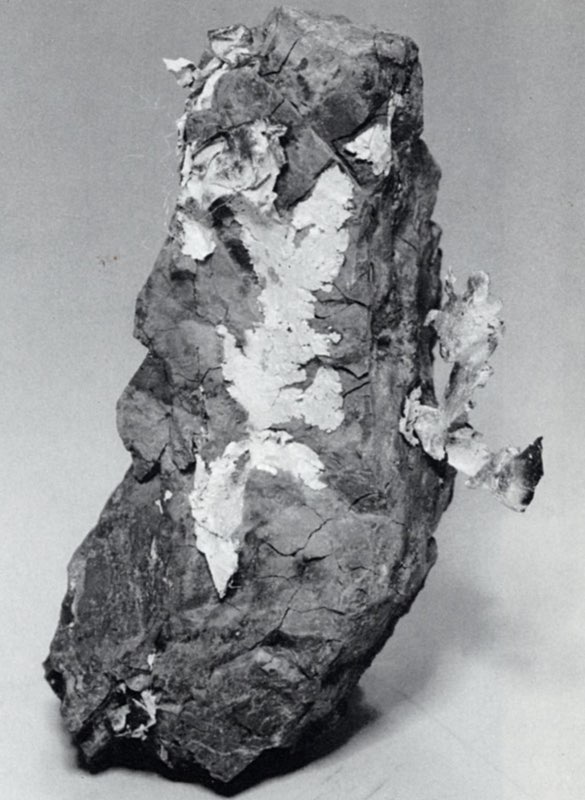
Note the interesting, ornate description by Arthur Lakes of specimens from the Colorado State Mining Bureau collection, at one time housed in the Capitol building: “A sample from the Colonel Sellers mine glistens with large galena crystals, amongst which are dark little caverns lined with perfect quartz crystals, and clinging to the crystalline walls and roof of these Aladdin grottoes, are trailing mosses and vines of silver with tufts and tussocks of mosslike silver from which depend black silver rootlets. One from the A. Y. and Minnie, Leadville, is a black rock covered with black, wriggling serpents. These silver forms are doubtless tarnished with manganese” (Lakes, 1895). Lakes’ “manganese” was probably acanthite.
Lakes also describes another beautiful silver specimen “from the Maid of Erin which is a mass of black manganese traversed by narrow seams of quartz from which issue beautiful leaves of silver foil. Another specimen shows wire silver issuing from crevices and tiny caverns lined with quartz crystals resembling tangled rootlets of moss, colored almost black, these rootlets being curled like celery stalks. Another rock is gray and black with silver sulphurets in which are many little caverns lined with quartz crystals, on the bottom of which appear clusters of wriggling snakes of silver like the locks of Medusa” (Lakes, 1895).
Silver Halides
“The prevailing varieties (of silver halides present in Leadville) are the green chlorobromide embolite, Ag(BrCl) [bromargyrite), and the colorless chloride cerargyrite, AgCl (chlorargyrite), each of which contains a very small amount of the iodide molecule. Brilliant yellowish crystals along joints in lead carbonate ore were found in the Weldon mine but were not analyzed” (Emmons et al., 1927). Emmons stated that the chloriodide was also present in less quantity and mentioned minute yellow crystals of iodargyrite (Agl), in the Chrysolite mine. These were also found in the Evening Star and Morning Star mines (Ricketts, 1883).
“The mineral embolite is invariably light greenish, soft, and sectile and does not change color on exposure to light. It occurs in scales and plates, as single grains or aggregates of such grains, and as rough crystalline coatings on the walls of crevices. The crystalline structure can be seen through a magnifying glass” (Emmons et al., 1927).
Sphalerite
(ZnFe)S
“With the exception of pyrite, sphalerite was the most abundant mineral in the Leadville ores” (Emmons et al., 1927). Most commonly it was associated with pyrite and galena and ranged from a dark brown color to an almost metallic black. Some of the coarse orebodies contained vugs of twinned sphalerite. Crystals up to 13 mm were found in the Moyer, Tucson, A. Y. and Minnie and other mines on Iron Hill. The Julia-Fisk, Little Jonny, Matchless, Resurrection and Wolftone also produced sphalerite crystals.
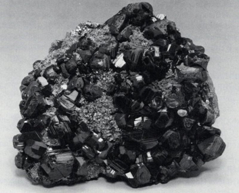
Vivianite
Fe3(PO4)2·8H2O
Another mineral which was found at least in small quantities in all the oxidized ores of Leadville is vivianite. It usually occurred as “indigo-blue to bluish green flat prismatic crystals” with striated faces. It occurred both as single crystals and crystalline druses (Emmons et al., 1927).
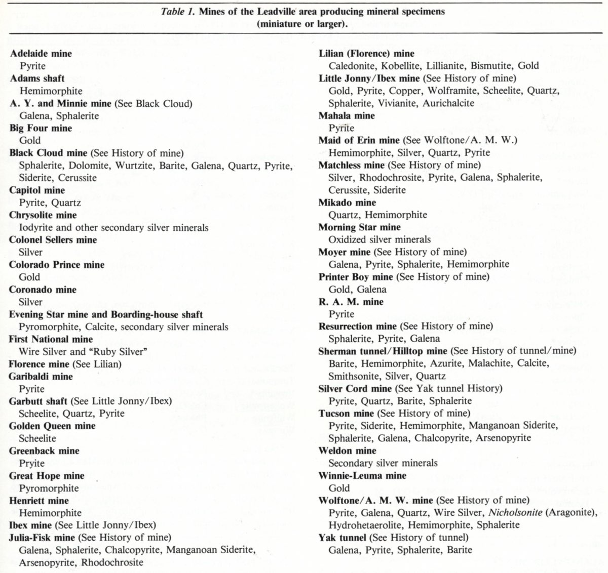
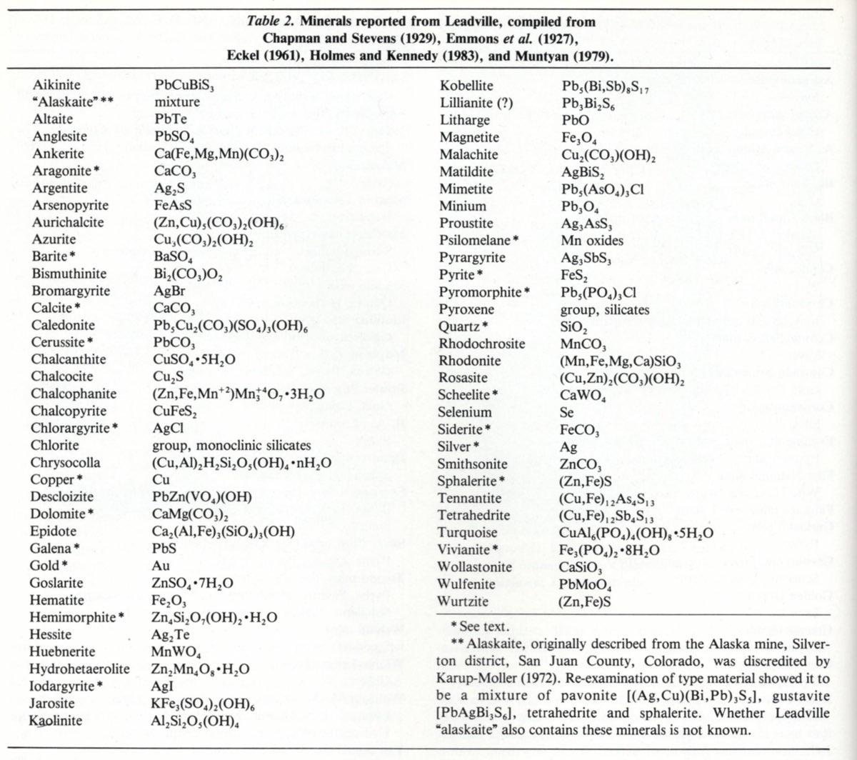
Acknowledgements & Bibliography