With over 22,000 historical mine locations in the USGS MRDS database of mines, California has more gold mines that the next top four gold states combined. California was also the largest gold producing state up to 1965 with over 100 million ounces produced.
In recent decades other states have overtaken California in total gold production, mostly as a product of open-pit mines or byproduct of copper mining. However, California remains the premier state for the independent miner looking to find gold by placer mining methods or by metal detecting.

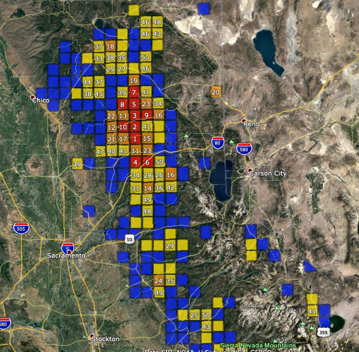
WMH Gold Maps for Google Earth Pro are designed to locate areas with high potential for finding placer gold. The California Gold Map will be used in this article to analyze regions of high gold potential by looking at PLSS townships that contain both historical gold mines and active placer mining claims, indicators that gold is being actively mined in these areas in modern times.
Townships that contain both active placer claims and historical gold mine records are shaded in one of the following colors based on how many active placer claims are in the township: 1 – 10 claims: blue; 10 – 50 claims: yellow; 50 – 100 claims: orange; More than 100 claims: red
Additional images in this article will contain more data points. Yellow circles are gold mines, hexagonal markers are PLSS sections that contain active placer mining claims, and blue markers with pick axes are district locations.
Township PLSS numbers cited in this article are in the same format used in the BLM MLRS application, and can be copied and pasted directly into the MLRS search form.
Related: Researching Mining Claims with the BLM MLRS
California can be divided into three primary regions for gold analysis – Northern (Klamath Mountains), Central (Sierra Nevada), and Southern.
This article will explore California gold regions from a broad perspective. Subsequent articles will look more closely at the state’s gold regions individually.
Sierra Nevada Region
California’s Sierra Nevada Mountain Range is by far the top gold region in the state. With well over 10,000 gold mines and thousands of active placer claims, this region has the state’s largest historical gold production totals and the most active modern placer mining districts.
This gold belt trends north to south for over a hundred miles with the greatest concentration of gold mines in Sierra, Nevada, and Placer, and Plumas counties. These counties rank 1st, 2nd, 4th and 6th in our Top Ten Gold Counties in the United States list.
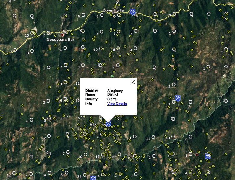
1. Downieville and Alleghany Districts (Sierra County)
Downieville was one of the first areas mined during the 1849 California Gold Rush. It is also one of the richest placer mining districts in the state. Today the Downieville district is still one of the most active placer mining areas in California.
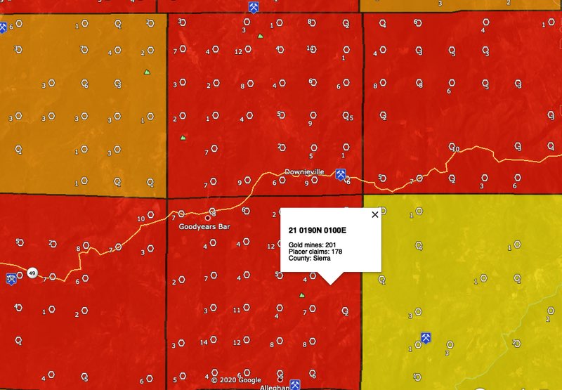
Downieville is in PLSS township 21 0200N 0100E which ranks third in the state for placer claim density. Four neighboring townships are also in the top ten.
The Alleghany district could be the center of gold activity in the entire state. Township 21 0180N 0100E has the highest placer claim density in California with 188 claims. Just to the north, township 21 0190N 0100E is second in the state with 178 placer claims and an incredible 201 historical gold mine records.
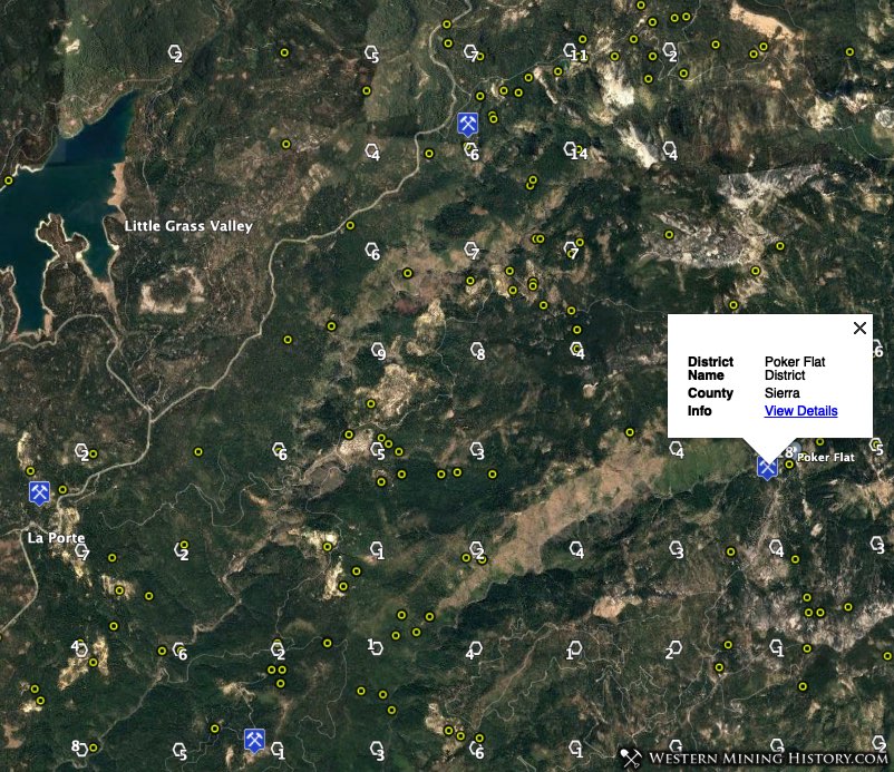
2. La Porte – Poker Flat – Rich Bar (Plumas and Sierra Counties)
Placer mining first occurred in this area in the 1850s with hydraulic mining starting in the 1860s. The gold output from these districts was enormous during the first few decades, with over $60 million credited to the La Porte district, over $14 million from the Poker Flat district, and over $9 million from the Rich Bar district.
Today this area has many of the top gold producing townships in the state. Township 21 0210N 0100E ranks 5th for placer claim density with 120 claims, 21 0220N 0100E 7th with 115 claims, and 21 0210N 0090E 8th with 107 claims.
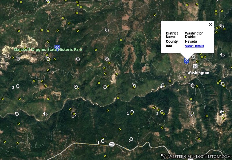
3. North Bloomfield – Washington – Lowell Hill (Nevada County)
The North Bloomfield and Washington districts contained some of the largest hydraulic gold mines in California during the period from the mid 1850s to the early 1880s. The famous Malakoff mine was once the largest hydraulic mining operation in the world.
The mines in these districts produced tens of millions of dollars in gold before 1900. Much gold remains however as illustrated by the high density of placer mining claims throughout the area.
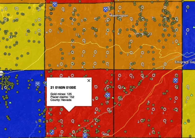
The Lowell Hill district may have been less notable than the other districts mentioned in this section, but today it is the center of a very active placer mining area. Township 21 0160N 0100E ranks 4th in the state for placer claim density with 152 claims and 21 0160N 0110E ranks 6th with 117 claims.
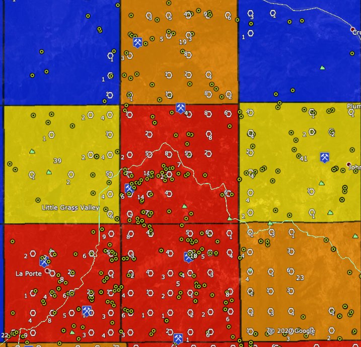
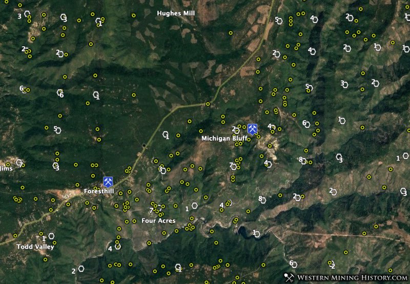
4. Foresthill – Michigan Bluff – Duncan Peak (Placer County)
Similar to the districts previously mentioned in this article, the Foresthill, Michigan Bluff, and Duncan Peak districts were originally worked in the 1850s and transitioned to hydraulic mining by the 1860s. The Foresthill district was particularly rich, producing over $25 million in gold.
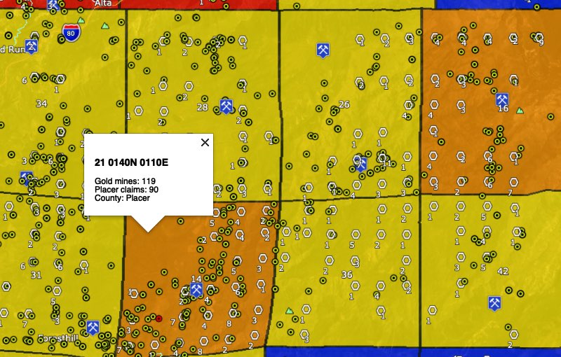
The block of eight townships shown in the image above are all among California’s top gold producing areas. Townships 21 0140N 0110E and 21 0150N 0130E have particularly high densities of placer mining claims allowing them to rank 14th and 16th in the state.
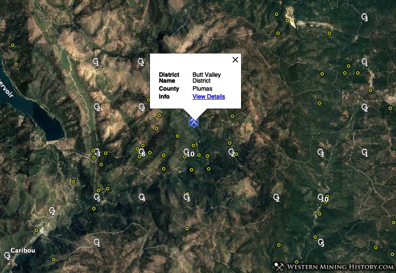
5. Butt Valley and Quincy Districts (Plumas County)
The Butt Valley district (not a typo) is located on the North Fork of the Feather River in Plumas County. The district location is described as “an extensive area that lies between Lake Almanor on the north and the Virgilia-Twain area on the south and southwest.”
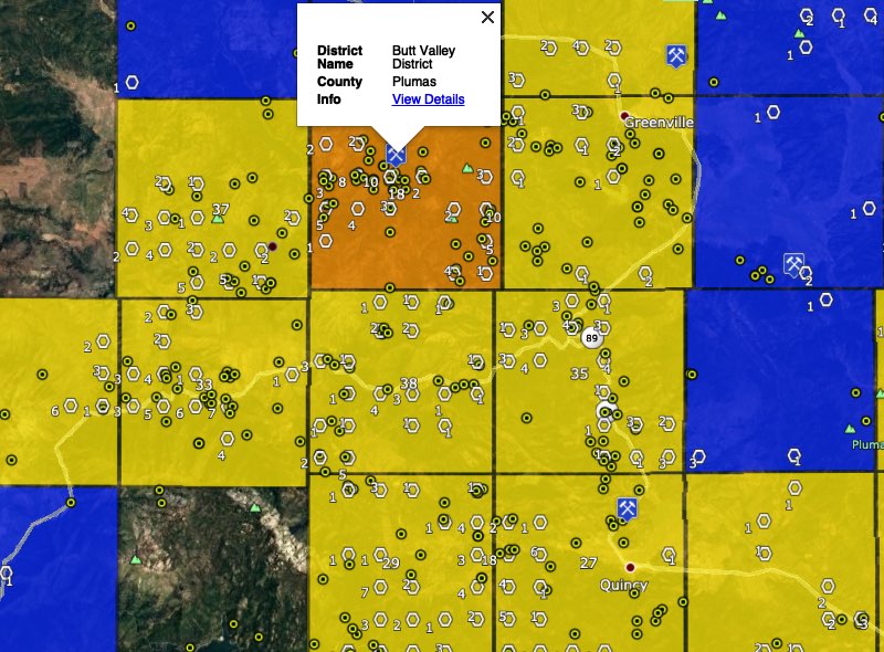
The Feather River and its tributaries were mined for “vast amounts of placer gold” during the Gold Rush years starting in the 1850s.
The center of the Butt Valley district is the once prosperous gold mining town of Seneca in township 21 0260N 0080E (69 placer claims, 18th place). Seneca is now a ghost town but this area remains an active placer mining center.
The Quincy district is centered on the town of Quincy, county seat of Plumas County. Township 21 0240N 0090E ranks 27th with 48 placer claims.
The image above illustrates that many of the townships around the Quincy and Butt Valley districts are areas of high placer claim density.
Klamath Mountains Region
The Klamath Mountains in northwestern California is the second most important gold region in California. The principal gold districts are in Shasta, Siskiyou, and Trinity Counties.
Siskiyou County ranks 9th our Top Ten Gold Counties in the United States list.
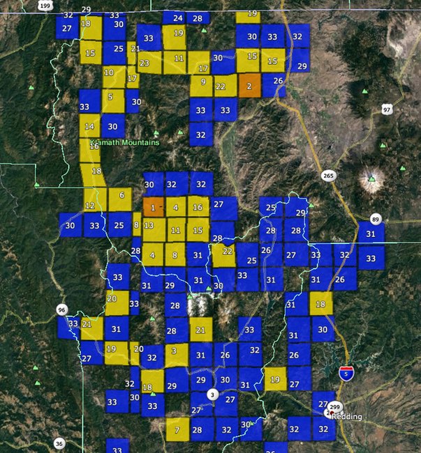
1. Klamath River Districts
The top spot was difficult to choose as the number one gold township in the Klamath Mountains is in the Salmon River area. However, the gold districts along the Klamath River form a placer mining area that stretches along Highway 96 from Interstate Five to the town of Orleans, a distance of approximately 120 miles. This area is one of California’s most extensive gold regions.
This region was originally mined in the 1850s, and continues to be an active placer mining area. Thirteen of the state’s top gold townships are located on the Klamath River, with additional townships on gold-bearing tributaries.
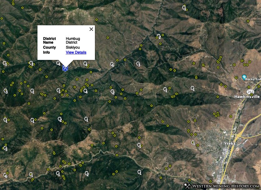
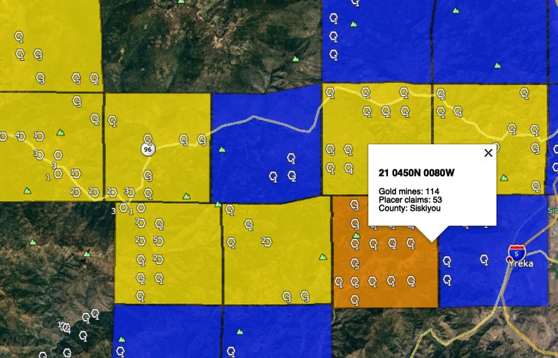
Township 21 0450N 0080W is the location of the Humbug District on Humbug Creek, a tributary of the Klamath River. This was an extremely rich placer mining area in the mid 1800s and is credited with over $15 million in gold production. Today the township ranks second for placer claim density in the Klamath Mountains region with 53 claims.
2. Salmon River Districts
The Salmon River is located in some of California’s wildest mountains, and continues to be an active placer mining area. The publication Gold Districts of California gives a good synopsis of the Salmon River districts:
This river is not as long as the Klamath or Trinity Rivers, but it flows through several rich and famous placer-mining districts. The most productive districts have been at Snowden and Sawyer’s Bar on the North Fork, Cecilville and Knownothing on the South Fork, and Forks of Salmon at the junction of the North and South Forks.
Probably the richest portion of the river was the 17-mile stretch of the North Fork between Sawyer’s Bar and Forks of Salmon, a segment that had an estimated gold production of $25 million. Eddy’s Gulch, just south of Sawyer’s Bar, yielded $4 million.
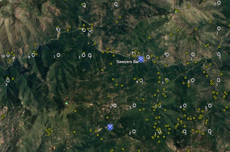
Modern placer claim density corresponds with the details given in the description above. Township 21 0400N 0120W, which is in the segment of river west of Sawyer’s Bar that reportedly produced $25 million in gold, is the top gold township in the Klamath Mountains with 63 claims.
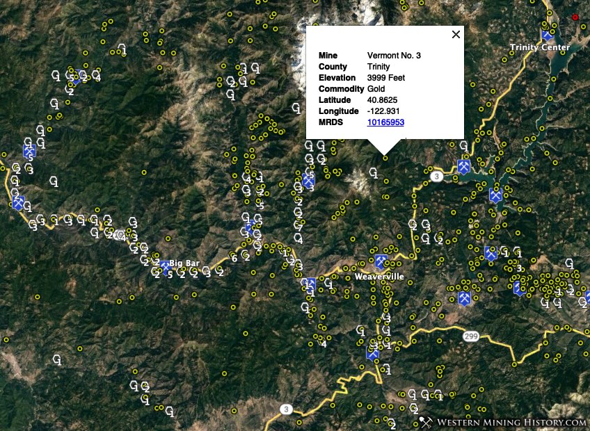
3. Trinity River Districts
The various districts along the Trinity River are collectively credited with over $35 million dollars in gold production since the 1850s. Much of this production came from hydraulic mines and gold dredges.
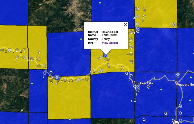
Modern day placer mining is concentrated west of Weaverville on the Trinity River, primarily in the Helena-East Fork and Big Bar districts. Canyon Creek, a tributary of the Trinity River, is also a location with many placer claims.
Township 21 0340N 0110W, location of the Helena-East Fork district, is ranks number 3 in the Klamath Mountains for placer claim density with 50 claims.
Interestingly the most productive historical mining areas, many of which were dredged, have few active placer claims today. It seems the dredges did a thorough job of extracting gold from large areas of rich ground.
Southern California
The gold districts of Southern California are spread throughout a vast area that is largely desert but includes mountainous areas known as the transverse and peninsular ranges.
Click here to view a map of California’s geomorphic provinces to get a better idea of the geography of the gold districts in the southern part of the state.
While Southern California has produced far less gold than the Sierra or Klamath mountains, it nonetheless has a long history of gold production and many districts are still active placer mining areas.
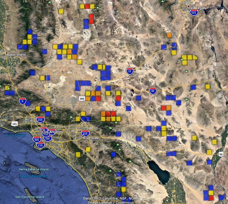
The desert regions of Southern California have large surface mining operations for commodities like borax and potash. These areas will have large land areas covered in placer claims, in some cases having over 500 in a single township. Some of these townships happen to have a small number of gold mines adjacent to the modern surface mines, so by the methodology used to create the WMH Gold Maps, these townships are identified as areas of high gold potential when they are likely not.
Due to this complication with modern industrial surface mines, more care is needed in identifying and researching active gold mining areas. Whereas the previous regions were analyzed by looking first at claim density and then adding detail from the historical records of the corresponding mining districts, with Southern California we start mining districts that are known prospecting areas and look at the claim density as a secondary attribute.
With less emphasis on analysis of claims density, the Southern California gold districts are listed here in no particular order and without being ranked.
Known Placer Gold Areas of Southern California
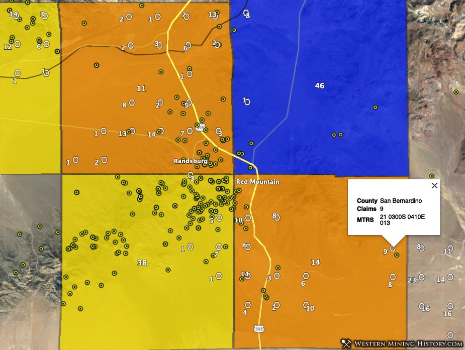
Randsburg – The Rand district is Southern California’s largest historical gold producer. Today the area is popular with prospectors and prospecting clubs own claims that can be used by members.
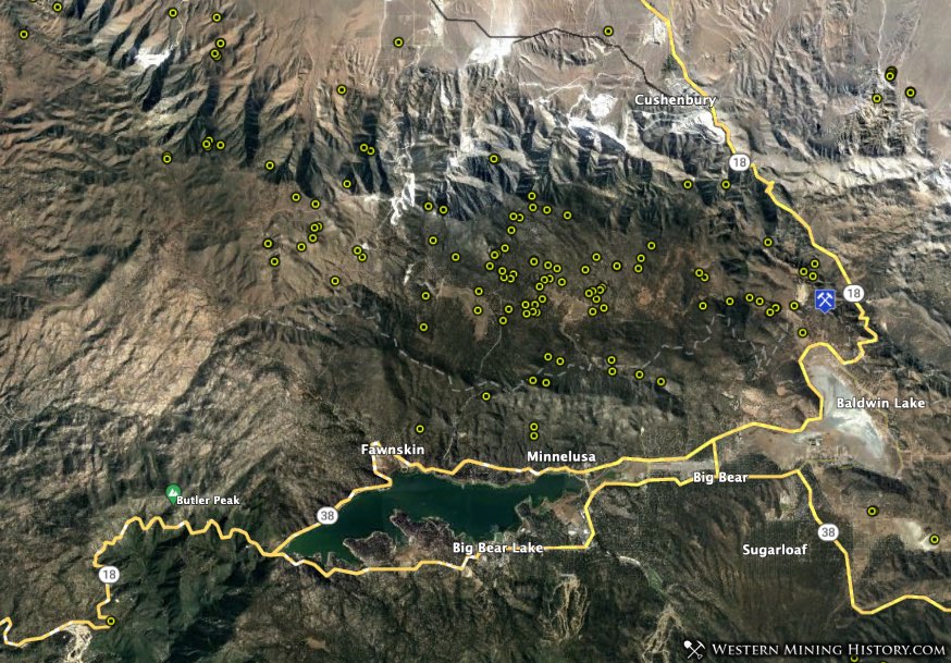
Holcomb Valley and Baldwin Lake – Holcomb Valley and Baldwin Lake districts are on the north side of the San Bernardino Mountains near Big Bear.
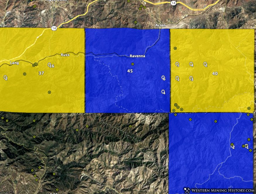
Acton – The Acton district is just south of Lancaster. Townships 27 0040N 0130W (10 placer claims) and 27 0040N 0120W (15 placer claims) are the center of gold activity today.
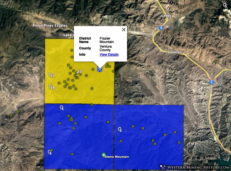
Frazier Mountain – The Frazier Mountain district is in the northeast comer of Ventura County in the general vicinity of Frazier Mountain. With over 50 historical gold mines, this is one of Southern California’s more significant gold districts.
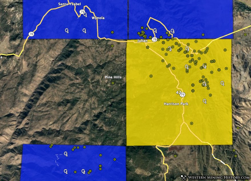
Julian – The Julian-Banner district was one of Southern California’s premier lode gold areas. Gold prospecting continues in this district today with over 10 active placer claims in township 27 0130S 0040E.
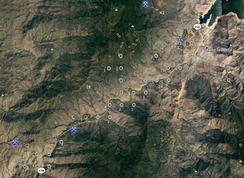
Keyesville – The Keyesville and Kern River districts are located northeast of Bakersfield. This section of the Kern River was the site of a gold rush in the 1850s. Today roughly 20 miles of the river between Keyesville and Bakersfield has active placer claims.
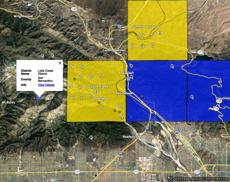
Lytle Creek – The Lytle Creek district is northwest of San Bernardino in the San Gabriel Mountains. With 34 placer claims, township 27 0020N 0060W is one of Southern California’s most active modern placer mining areas.
Conclusion
California contains an incredible number of historical mines and mining districts spread over vast areas of mountain and desert terrain. Summarizing the state’s gold areas in a single article is almost an impossible task.
While this guide gives an overview of California’s top placer gold areas, it barely scratches the surface of what is actually out there. Future articles will take a closer look at many of the areas mentioned here, and explore areas that were not included.
In the meantime gold districts, mines, and placer claims can be researched for the entire state with the WMH Gold Maps for Google Earth Pro.
Notes on the Data Used in this Analysis
Claim counts were created using BLM active placer claim data distributed on August 1, 2020.
Gold mine numbers cited for each township are the number of USGS records, some of which are duplicates.