WMH Gold Maps for Google Earth Pro are designed to locate areas with high potential for finding placer gold. A core feature of these maps is the highlighting of townships that contain both active placer mining claims and historical gold mines.
The screenshot below uses data from the Oregon Gold Map and shows gold-bearing PLSS townships across the state (this view was created with Google My Maps). The highest concentrations of gold-rich areas are in the northeast and southwest corners of the state.

Townships that contain both active placer claims and historical gold mine records are shaded in one of the following colors based on how many active placer claims are in the township: 1 – 10 claims: blue; 10 – 50 claims: yellow; 50 – 100 claims: orange; More than 100 claims: red.
Additional images in this article will contain more data points. Yellow circles are gold mines, hexagonal markers are PLSS sections that contain active placer mining claims, and blue markers with pick axes are district locations.
In this analysis we will be looking at the gold townships highlighted by the WMH Oregon Gold Map and identifying which have the highest potential for gold discovery.
Township PLSS numbers cited in this article are in the same format used in the BLM MLRS application, and can be copied and pasted directly into the MLRS search form.
Related: Researching Mining Claims with the BLM MLRS
The following list summarizes the top gold townships in Oregon as ranked by the WMH Oregon Gold Map.
Note: Sometimes industrial surface mining operations cause anomalies in the analysis. The #1 ranked township in Oregon is 33 0290S 0030E located in Douglas County (the only red square on the map). While this township does have a few historical gold mine locations, this is not known as a prominent gold area.
Research has revealed that a company holds many claims in this area with the intention of operating a surface mine for clay minerals. This township, and adjacent township 33 0290S 0040E (rank 28) should be ignored as areas of high gold potential.
1. Baker County – Upper Burnt River
An interesting result provided by the Oregon Gold Map data was that some of the most active placer gold townships in the state, including the top two townships in this list, are located in the Upper Burnt River district, an area that is not as well known for it’s historical gold production as some of the county’s more famous districts like Auburn or Sumpter.
This district is located in the southern part of Baker County, accessible by Highway 245 and near the small towns of Hereford and Bridgeport.
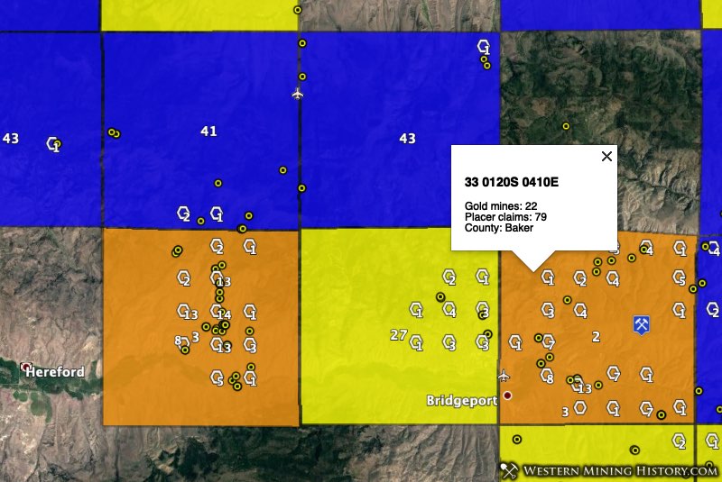
The top two gold areas by placer density (#2 and #3 by placer claims in the state, adjusted for the anomalous township mentioned above) in the state of Oregon are 33 0120S 0410E (79 placer claims, 22 gold mines) NW of the town of Bridgeport, and 33 0120S 0390E (76 placer claims, 35 gold mines) east of the town of Hereford.
Township 33 0120S 0400E (18 placer claims, 6 gold mines), seen as the yellow square between the orange squares in the image above, ranks 27 in the state by number of placer claims.
Not much has been written about this district. In the 1968 USGS publication Principle Gold Producing Districts, the district is described as “a large district and includes many localities that have produced small amounts of both placer and lode gold. Early production data are scant, but apparently some placers were worked before 1900. Total gold production through 1959 was about 9,300 ounces from all sources.”
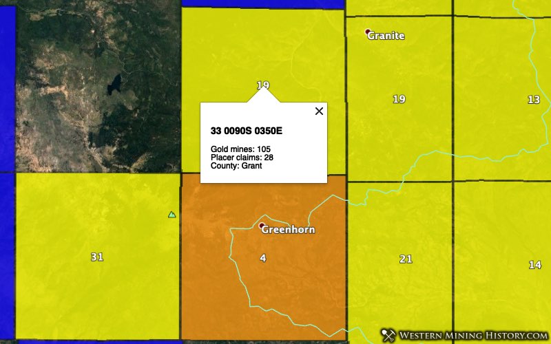
2. Baker and Grant Counties – Greenhorn
The Greenhorn District, location of the ghost town of Greenhorn City, is one of Oregon’s oldest gold districts. Placer gold was first mined here in the 1860s, eventually transitioning to lode mining as the placers ran out.
This district is in a remote part of Oregon’s Blue Mountains and straddles the Baker-Grant county line.
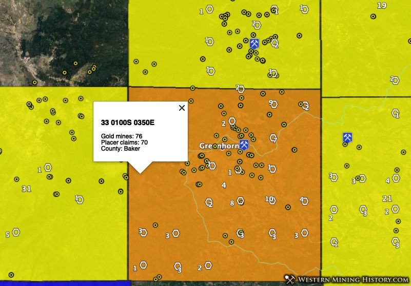
Township 33 0100S 0350E has 70 active placer claims and 76 USGS gold mine records, making it the third ranked gold township in the state. Neighboring townships 33 0090S 0350E (28 placer claims, 105 gold mines), 33 0100S 0352E (25 placer claims, 11 gold mines), and 33 0100S 0340E (13 placer claims, 46 gold mines) are also some of the state’s best gold areas.
While this area is generally known as the Greenhorn district, some sources divide the area into several districts, with the Alamo district to the north and the Bonanza (Geiser) district to the east.
3. Josephine County – Illinois River
The placer fields of southwest Oregon are the earliest to be mined in the state. Tributaries of the Illinois River are said to have been mined for gold as early as 1852. Few records exist from this period so the total gold production for the area is not known. What is known is that almost 170 years after the first miners entered this area, gold mining is still actively being pursued.
The Illinois River district is west and north of Cave Junction, and extends almost 25 miles from south to north. The northern-most boundary of this district is just south of the Galice district.
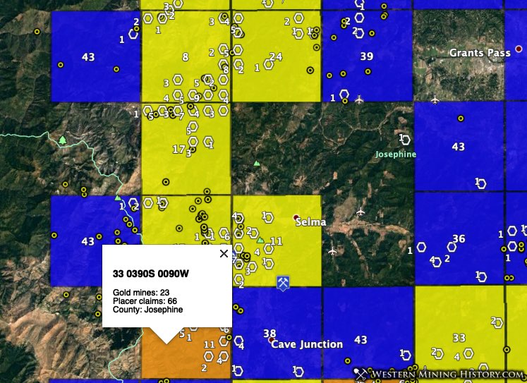
In the southern part of the district, township 33 0390S 0090W (66 placer claims, 23 gold mines) is the fourth highest-gold potential township in Oregon by number of placer claims. Adjacent townships 33 0380S 0090W (34 placer claims, 56 gold mines) and 33 0380S 0080W (39 placer claims, 12 gold mines) are also top areas.
In the northern part of the district, township 33 0360S 0090W (48 placer claims, 8 gold mines) has the seventh highest number of placer claims in the state. Several other adjacent townships also rank high, but some of them overlap with the Galice district to the north so not all claims can be assigned to the Illinois River district.
Overall this is a large district with a lot of active placer mining areas. The WMH Oregon Gold map allows closer inspection of these areas.
4. Josephine County – Waldo
The Waldo district is one of Oregon’s richest gold areas with over 200,000 ounces of recorded placer production. The area was first worked in 1853 and almost a century later significant gold was still being recovered here. From 1932 through 1959 the district produced 18,614 ounces of gold from placer mines.
The Waldo district is south and southeast of Cave Junction, and extends to the California border. The ghost town of Waldo is in the western part of the district.
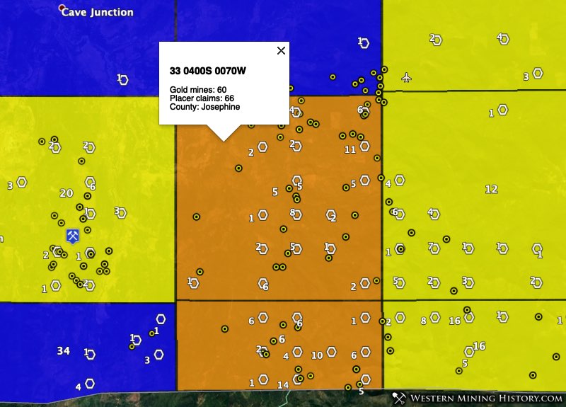
Township 33 0400S 0070W (66 placer claims, 60 gold mines) ties for the the fourth highest-gold potential township in Oregon by number of placer claims. To the south, township 33 0410S 0070W (55 placer claims, 25 gold mines) is notable as the section is less than half the usual size due to its location against the California border, yet it still manages to rank fifth in the state for the number of placer claims.
To the west and east of the townships mentioned above, townships 33 0400S 0060W (38 placer claims, 14 gold mines), 33 0410S 0060W (33 placer claims, 15 gold mines), and 33 0400S 0080W (26 placer claims, 32 gold mines) are also significant gold areas.
5. Josephine County – Galice
Placer mining began on Galice Creek in 1854. By the 1880’s the richer deposits were mined out and Chinese took over many of the operations. The Old Channel mine was the largest hydraulic mine in Oregon. From 1914 through 1959, placer gold production for the district was 7,258 ounces.
The Galice District is west and north of the town of Galice, in northern Josephine County.
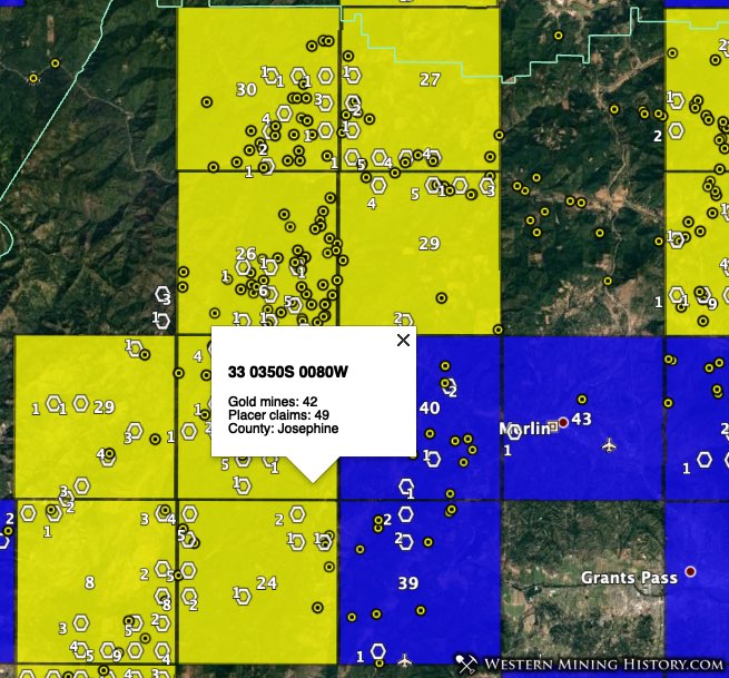
Township 33 0350S 0080W (33 placer claims, 15 gold mines) ranks sixth in the state for gold potential based on number of placer claims. Seven additional townships in the area have 10-50 active placer claims.
The townships in the southern part of the district overlap with the Illinois River district so accurately assigning the claims to each district is problematic, however it remains clear that the Galice and Illinois River districts together form a rich gold belt that covers over 40 miles from north to south in Josephine County.
6. Jackson and Josephine Counties – Upper Applegate
The Upper Applegate district is located in the southwest corner of Jackson County, and the extreme southeast corner of Josephine County. The area was first mined in 1853 and is described as primarily a placer district. Up to 1959 it is estimated that over 200,000 ounces of placer gold have been recovered in this district.
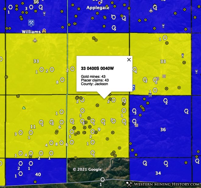
Township 33 0400S 0040W (43 placer claims, 43 gold mines) ranks 8th in the state for number gold-related placer claims. To the west, township 33 0400S 0050W (39 placer claims, 6 gold mines) ranks 10th in the state.
7. Linn County – Quartzville
Quartzville sneaks into a high position on this list due to the strength of just one township, but this is a small district compared to others on the list. Quartzville was an active mining camp and district starting in the 1860s but was abandoned well before the turn of the century. The area remains popular with recreational gold prospectors.
The Quartzville district is southwest of the town of Detroit, and can be accessed on the Quartzville Backcountry Byway which runs between Detroit and Sweet Home.
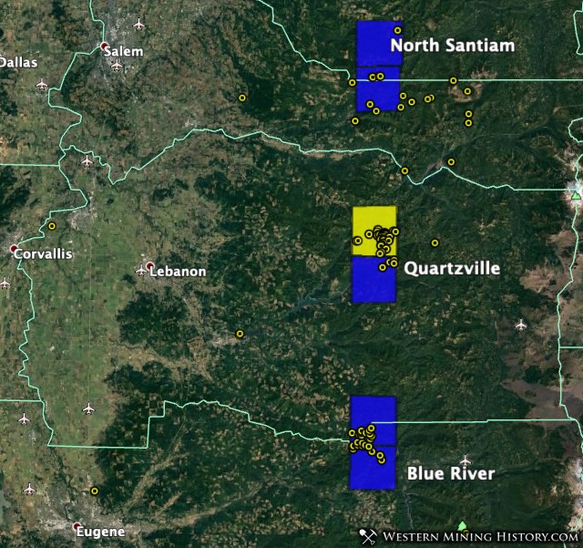
Township 33 0110S 0040E (41 placer claims, 60 gold mines) is the yellow square at Quartzville in the image above and contains the vast majority of the active mining area in the district.
8. Baker and Grant Counties – Granite, Sumpter
Granite and Sumpter are two of the more famous mining towns in the state. Each was a prosperous gold camp, and both survive today as living ghost towns and centers of active placer mining areas. Additional adjacent districts form a large area with both extensive historical gold production and active modern placer mining activity.
The Granite District is in Grant County while the Sumpter District is in Baker County to the east. The 1912 USGS publication Mining Districts of the Western United States identifies a district called Buck Gulch between the Granite and Sumpter Districts, which is notable for its high density of modern placer claims.
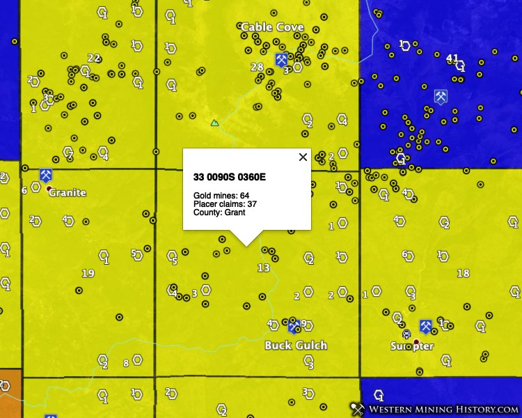
Township 33 0090S 0360E (37 placer claims, 64 gold mines), in the district identified as Buck Gulch, ranks 12th in the state for number of gold-related placer claims. Township 33 0090S 0370E (31 placer claims, 41 gold mines), location of Sumpter, and township 33 0090S 0352E (28 placer claims, 11 gold mines), location of Granite, are also top gold townships.
Also of note is township 33 0080S 0360E (16 placer claims, 89 gold mines), location of the Cable Cove district.
9. Baker and Malheur Counties – Lower Burnt River Valley, Mormon Basin
The Lower Burnt Valley district is located in southeast Baker County and is known primarily as a lode district. However, the USGS reports that most of the placer gold production for the district has gone unreported, and that “nearly all the gulches and streams that drain into the Burnt River in this district contain auriferous placers.”
The Mormon Basin district extends from the town of Rye Valley to the southwest and just over the Malheur County line. Placers in the area were worked as early as 1863 and while the district is credited with over 50,000 ounces of placer gold, it is likely much of the early production was unrecorded.
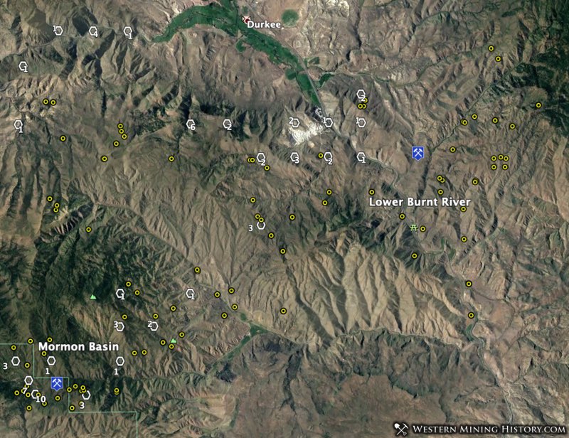
Township 33 0130S 0420E (37 placer claims, 56 gold mines), located in the Mormon Basin district, ties for 12th place based on the number of active placer claims. Township 33 0120S 0430E (25 placer claims, 23 gold mines), located in the Lower Burnt River Valley district, ranks 20th in the state.
10. Lane County – Bohemia
The Bohemia District is located 35 miles southwest of Cottage Grove in Lane County, Oregon. Most of the recorded gold production is from lode mines, but the district was first discovered in 1858 and placer production from the 1800s is largely unrecorded.
The numerous active placer claims in the district tell the story that the records don’t – that Bohemia is one of Oregon’s top placer gold locations.
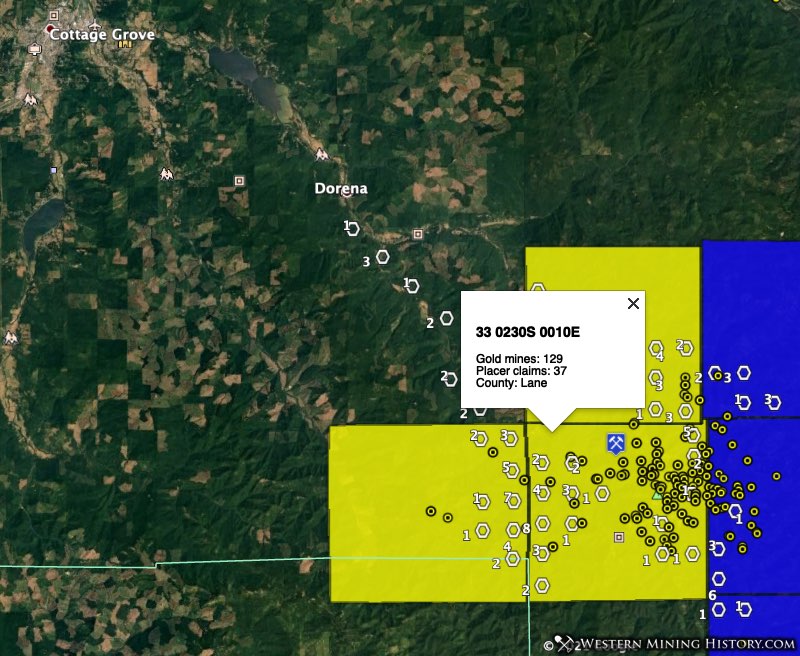
Township 33 0230S 0010E (37 placer claims, 129 gold mines) ties for 12th among gold-bearing townships in Oregon. Adjacent townships 33 0220S 0010E (20 placer claims, 10 gold mines) and 33 0230S 0010W (25 placer claims, 8 gold mines) are also high-ranking gold areas.
Other Oregon Placer Gold Locations
This list looks at some of the top placer gold locations in Oregon, but it is hardly complete. The Oregon Gold Map identifies many areas throughout the state where active placer claims and historical gold mines are present. Many of these are little known and have not had much history recorded about them.
In Douglas County, the Drew, Ollala, Nugget, Riddle and Starvout districts all have active placer claims (even if it’s just one in the example of Ollala).
In Jackson County the Gold Hill and Ashland districts show some active mining activity based on claims.
In Union County the Camp Carson District has over 20 active placer claims.
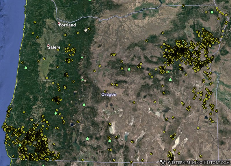
This is just a partial list of districts that did not make this top ten list. The image above illustrates the distribution of all USGS gold mine records for the state of Oregon, many of which reside in active placer mining areas.
Conclusion
While it is illegal to mine or prospect for gold on an established mining claims, there is still a lot of unclaimed ground, even in historically important mining areas.
Using the Oregon Gold Map, areas with high gold potential can be quickly identified and used as the basis for additional research. Prospectors can focus on the most active placer gold areas and attempt to discover their own claim, or they can look at those areas on the map that have many historical gold mines and few claims in an attempt to stake a claim in an area with less competition.
Notes on the Data Used in this Analysis
While the methods used here allow for a quick overview of all potential gold areas in the state, they are not perfect. Occasionaly some historical gold mines will be located near modern surface mining operations for things like evaporite minerals, and the the correlation between active placer claims and the adjacent historical gold mines are coincidental only and do not indicate an area with strong gold potential.
Claim counts were created using BLM active placer claim data distributed on August 1, 2020.
Gold mine numbers cited for each township are the number of USGS records, some of which are duplicates.