Western Mining History distributes location data on active mining claims based on data retrieved from the Bureau of Land Management (BLM) MLRS application. The purpose of this guide is to aid in the understanding of what the BLM claims data is useful for, and how to use the data to assist in your research.
Note: The BLM (Bureau of Land Management) LR2000 was renamed the Mineral & Land Records System (MLRS) in early 2021. Recently the BLM has put a new tool online with a map based search which is slow and complicated, and creates confusion as to what tool you should use. The methods in this article apply to the search tools found at the following URL: https://reports.blm.gov/reports/MLRS
Mining claims are generally located within the Public Land Survey System (PLSS) by Meridian, Township, Range, Section (MTRS). The PLSS is a grid system that subdivides geographical areas into distinct units. This guide will not delve into the details of the PLSS system, we recommend searching for guides on this subject or reading the tutorial provided by the Wisconsin Department of Natural Resources.
Mining Claim Data at Western Mining History
Mining claim data distributed by Western Mining History consists of a custom index of active claim data (pending or closed claims are not included) that has been merged with location data for PLSS sections. This allows active claim information to be displayed on maps to give a general idea of where claims are located.
The claims data at WMH is used in various tools like the Mines Explorer Pro, WMH Gold Maps, and the Mining Claims Research Tools. This data is a snapshot in time and is intended to illustrate broad trends in claim distribution and to serve as a reference for doing claims research. This reference data is not updated on a regular schedule.
Important note: while the claims data distributed by WMH is deemed accurate, it is not guaranteed. The BLM MLRS should always be used to verify information on claims you are interested in.
Important note: if you want to locate the exact boundaries of a claim, you need to go to the county recorder’s office where the claim is located to retrieve full location notice. Mining claims can’t be precisely located with the data available from the BLM MLRS.
Claims Research Steps
Regardless of the source of your claims reference data, you always need to double check the data with the BLM MLRS application.
It doesn’t matter if the third party reference data, from WMH or another source, is one month old or a year old, you still have to verify it with the MLRS.
The basic steps for researching mining claims with the BLM MLRS are:
- Locate areas that you are interested in prospecting and find the MTRS values of the PLSS sections that define those areas.
- Use the MTRS values to look up active (or closed if desired) mining claims with the BLM MLRS.
- Further narrow down the claim locations to the quarter section, and make a note on that spot in your mapping application of choice. We will use Google Earth Pro in this article.
WMH claims data tools are designed to make this process as easy as possible.
1. Find the MTRS Values for the Land You Want to Prospect
You can find MTRS values for PLSS sections, formatted for use in the BLM MLRS, in the various tools that WMH distributes with premium memberships. Sample MTRS values are available to non-members in articles like Where to Find Gold in California. An example from that article is 21 0200N 0100E, which is the location of Downieville – one of the most productive gold areas in the state.
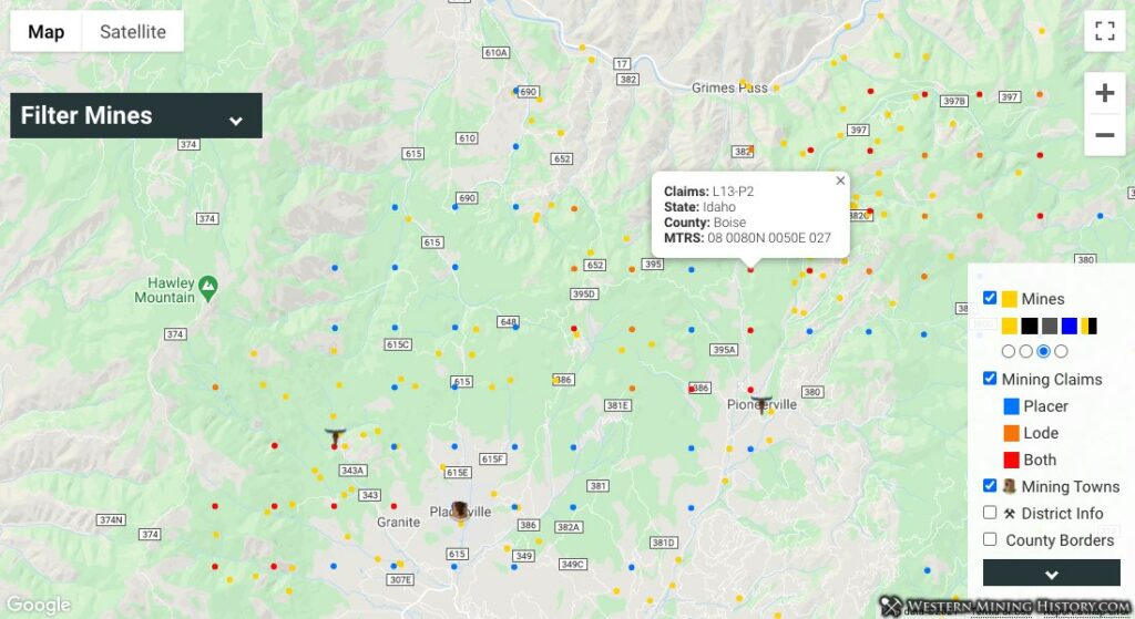
The following image shows placer claim reference data from the WMH Mines Explorer Pro. The MTRS value for a section that contains thirteen lode claims and two placer claims is 08 0080N 0050E 027.
If you would like to check for claims in PLSS sections that are not included in the reference claims data (for either closed claim or newly filed claims since the reference data was created), you can use full PLSS section centers by county data included in the WMH Claims Research Tools.
2. Looking Up Claim Data with the BLM MLRS
Using an example similar to the map image above, let’s explore section “08 0070N 0050E 004” with the claims value of “L5-P5”. This MTRS value is in the exact format used in the MLRS and can be used to shortcut the slow and cumbersome search tools in that application.
Access the MLRS at the following link: https://reports.blm.gov/reports/MLRS
Note: the MLRS is a notoriously slow and unreliable app, so some patience will be required while doing research.
On the main page under “Public Mining Claim Reports”, click on “Mining Claims – Geographic Report”. You are now on the Geographic Report search form. Select the following fields to get a list of the mining claims in the PLSS section of interest:
Admin State - Choose the state you are looking at claims in unless it is Washington or South Dakota. Admin state for Washington is Oregon. Admin state for South Dakota is Montana
Meridian Township Range Section (you can skip the “Meridian Township Range” field) – Copy the value from the Mines Explorer Pro “08 0070N 0050E 004”. Click on the form outside of the MTRS field, then wait a few seconds for the field to register (see image below, the field value turns blue)
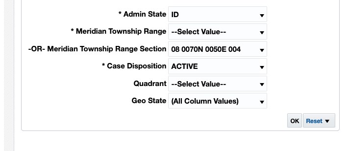
Alternately you can search claims in an entire township (and the 36 sections within) by removing the last three digits of the MTRS number and entering that value in the “Meridian Township Range” field . The value you would use based on our example is “08 0070N 0050E”.
Case Disposition – Choose active, or alternately choose closed if you want to research closed claims.
Click the “OK” button at the bottom of the page and grab your favorite beverage because the MLRS can take a while to return the results.
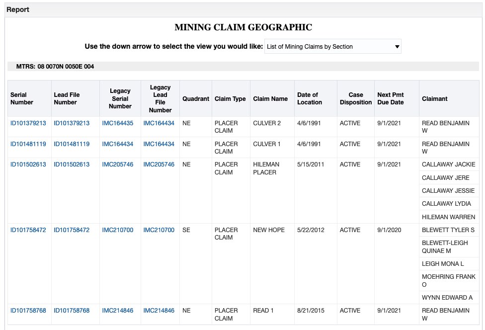
Clicking the link for each “Serial Number” value will download the full serial register page for that claim.
3. Narrow Down Results to the Quarter Section and Record the Results
Although you can’t find the exact claim boundaries without getting a copy of the original claim record from the county recorder, you can narrow down where claims are to the quarter section.
In the image above, the “Quadrant” column indicates which corner of the section the claim resides in. Imagine each section having four quadrants – NW, NE, SW, SE. Our results above indicate that the five active claims in this section are located in the NE and SE quadrants, leaving the NW and SW quadrants free of claims.
Using another example from Josephine County Oregon, the MLRS tells us there are five active placer claims in PLSS section 33 0340S 0070W 003. The report also tells us that those claims reside in the NW, NE, and SE quadrants of that section. In Google Earth Pro, using the topo maps that come with the WMH Mine Discovery Tools, markers are added to the three corners that contain claims. The numbers on the markers are the number of claims in that quadrant.
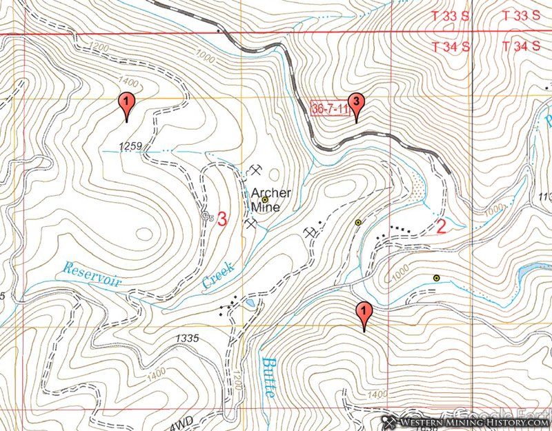
This gives us actionable information to use in the field. The quadrant southwest of the Archer mine is claim free, while the NW and SE quadrants have just one claim and might be worth exploring.
Researching Closed Claims
You may be interested in what claims were closed in various PLSS sections. Closed claims could be an indicator of where gold was once found, but is now unclaimed ground. Closed claims can be identified in the MLRS by the methods used above simply by selecting “Closed” in the Case Disposition field. However, what about all the sections that do not have active claims and therefore are not included in the various WMH tools listed above?
You could always manually format the MTRS values and input them into the MLRS but that is time-consuming and frustrating work. The WMH Claims Research Tools include files for Google Earth Pro that show all surveyed PLSS section centers – whether or not they have claims in them. This allows you to quickly and easily check any section for closed claims – or new active claims that were filed after the reference claims data was compiled.
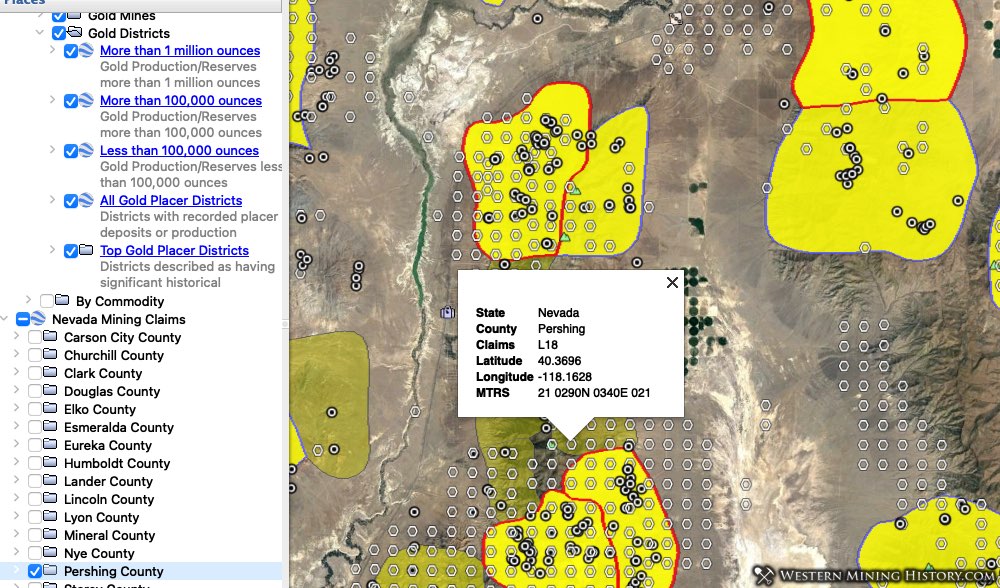
The image below is from Google Earth Pro with the WMH Arizona Gold Map and the PLSS section center data from the Mining Claim Research Tools. The colored squares are townships, and are some of Yavapai County’s top placer gold areas. The hexagonal markers with a number on them are the number of active claims in those sections. The info window contains the MTRS value for each section.
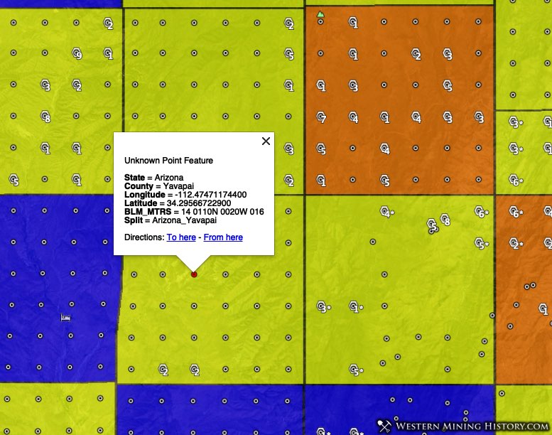
The section illustrated above (14 0110N 0020W 016) has no active claims. However, searching the MLRS for closed claims reveals that previously there were 15 placer claims and 31 lode claims filed in that section. And that is just for one section! While the majority of claims were abandoned because they were not worth working, some of them most likely still contain some gold.
With gold prices being very high in recent years, finding a decent claim could be well worth the effort.