The district locations and descriptions in this article are primarily based on the publication Mining Districts of Nevada by the Nevada Bureau of Mines and Geology. For districts with recorded gold placer mining activity, additional information has been included from the publication Placer Gold Deposits of Nevada – USGS Bulletin 1356.
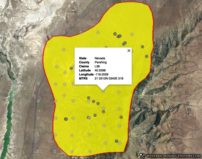
Images of district locations are from the WMH Nevada Mining Atlas.
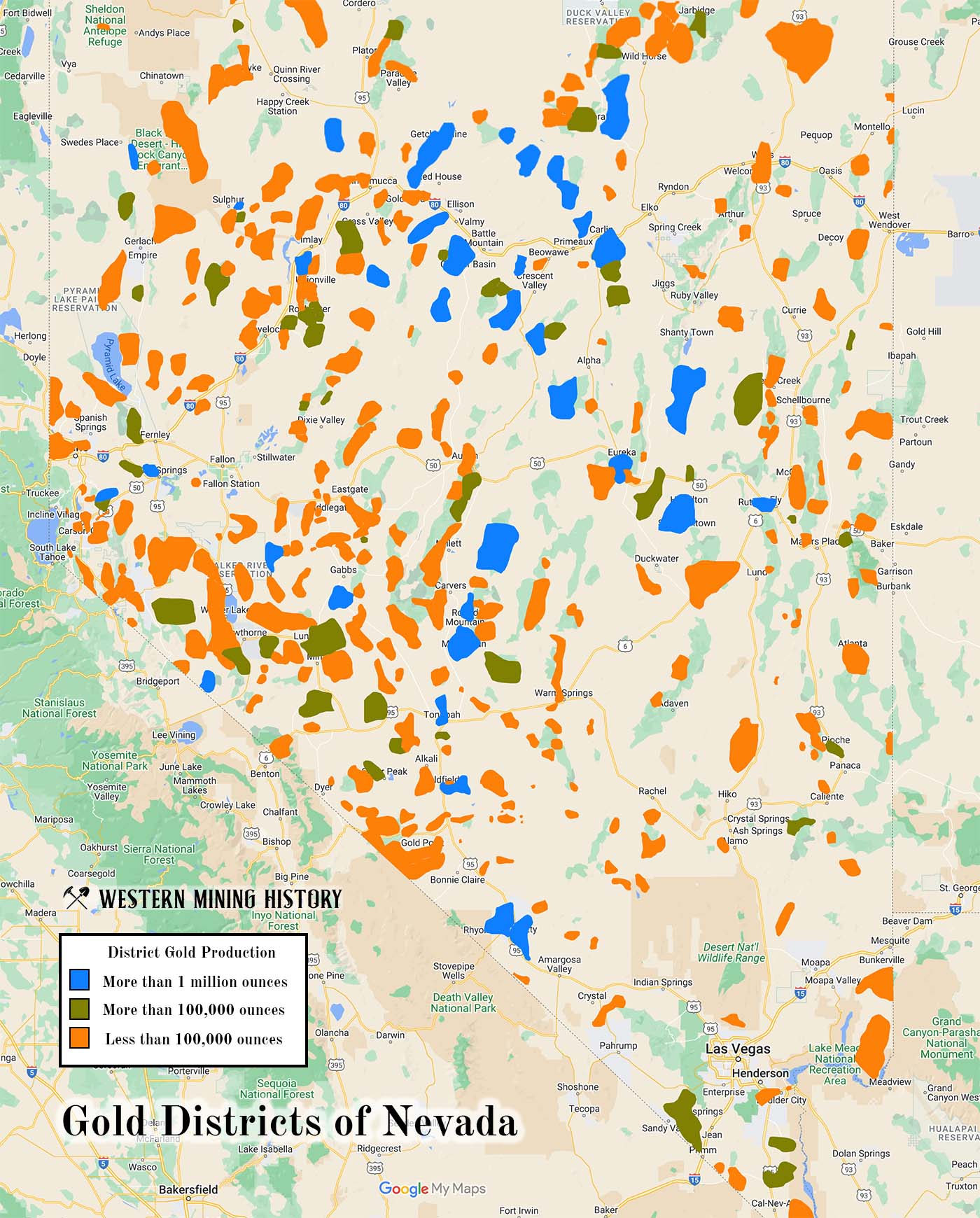
Nevada has a total of 368 distinct gold districts. Of the of those, just 36 are major producers with production and/or reserves of over 1,000,000 ounces, 49 have production and/or reserves of over 100,000 ounces, with the rest having less than 100,000 ounces.
Eighty-two districts are identified as having placer gold, even if very minor and with no recorded production. Of those placer districts, just 15 are considered significant gold producers.
This article will focus on significant Nevada gold districts that have production and/or reserves of over 1,000,000 ounces. Gold districts with significant records of placer gold production (although not with specific values for production like the previous category) will also be examined.
Significant Nevada Gold Districts
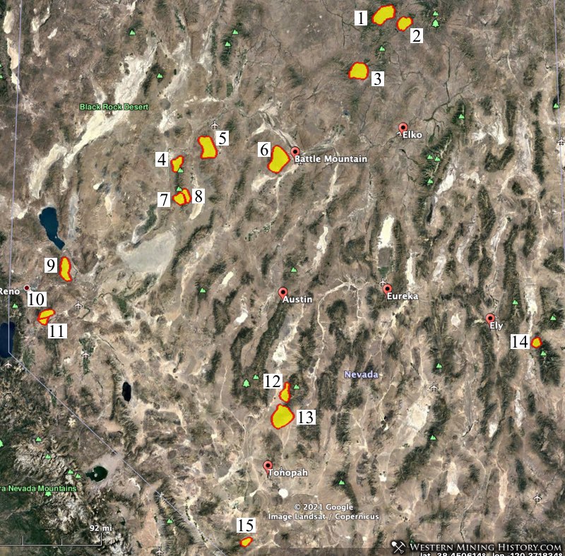
The following map images illustrate the distribution of Nevada’s most important gold districts (those that have production and/or reserves of more than 1,000,000 ounces). The images are roughly divided between the northern and southern part of the state. Each image is followed by numbered district descriptions that correlate to locations in the images.
Each district name is linked to a page with more information about the district from the publication Mining Districts of Nevada, and additionally Placer Gold Deposits of Nevada if there is a related entry. County names that are linked indicate that additional information is available from the publication Principal Gold Producing Districts of the United States by the USGS,
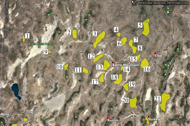
Note: the majority of the gold production in the districts represent in the image above (northern part of the state) is from modern open pit mines. Due to this, historical information on these districts often does not reflect the large amount of gold mined here in recent decades.
1. Leadville District – Located in Washoe County, The Leadville District was discovered in 1860. The district is located about 38 miles north of Gerlach, in the vicinity of Hog Ranch Mountain. Historically, silver and lead were the main products of mines in this district; production is now gold and silver.
2. Awakening District – Located in Humboldt County, The Awakening District was discovered in 1912. The original Amos district, which included the mining camp of Awakening, was located on the eastern slope of the Slumbering Hills about 7 miles southwest of the old Amos stage station and about 30 miles north of Winnemucca. Minor placer gold production is credited to this district.
3. Potosi District – Located in Humboldt County, The Potosi District was discovered in 1874. This district is now considered to extend from Kelly Creek Valley on the east to Preble at the south end of the Osgood Range just north of Preble Crossing of the Humboldt River. Minor placer production is associated with stream gravels on the east side of the Osgood Mountains.
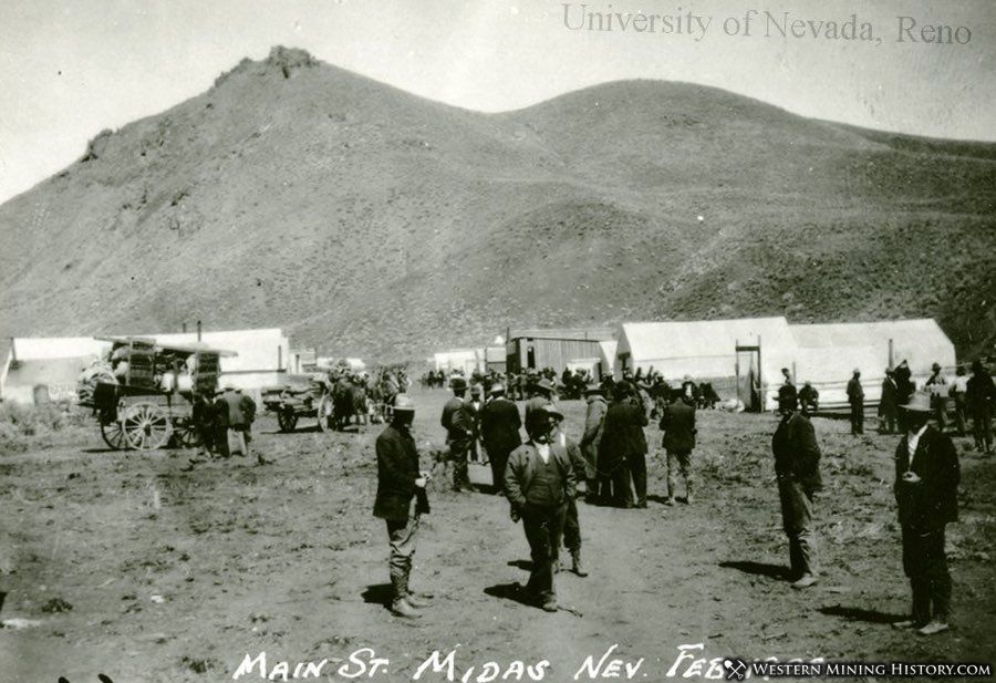
4. Gold Circle District – Located in Elko County, The Gold Circle District was discovered in 1907. The district covers the southeastern slope of the Owyhee Bluffs, between Midas and Fraziers Creeks. The original district name was Gold Circle and included the town of Rosebud. The town name was later changed to Gold Circle, and then to Midas. The district is commonly referred to as Midas. Minor placer production is credited to this district.
5. Independence Mountains District – Located in Elko County. The district includes all of the Independence Mountains north of Taylor Canyon and south of the Aura district, including the old Burns Basin antimony district and the gold-mining areas of Jerritt Canyon, Big Springs, and Gance Creek.
6. Ivanhoe District – Located in Elko County, the Ivanhoe district was discovered in 1916. The district is located in the Battle Creek Range north of Battle Mountain, and includes the drainage basins of Ivanhoe and Little Antelope Creeks. Ivanhoe is historically a mercury district, but recent gold production has overshadowed mercury.
7. Bootstrap District – Located in Elko County. This district is part of the Carlin Trend. The area was known as the Boulder Creek district from 1953 to about 1960, then Bootstrap after the Bootstrap Mine became a major gold producer. Today the South Arturo open pit and underground mine is a major gold producer.
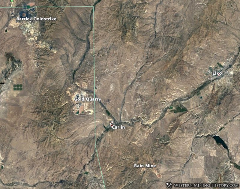
8. Lynn District – Located in Eureka County, the Lynn district was discovered in 1907. The district is located in the Tuscarora Mountains about 19 miles northwest of the town of Carlin, and is part of the Carlin Trend. The Barrick Goldstrike mine now encompasses the entire district, and is one do the world’s largest open pit gold mines.
9. Sulphur District – Located in Humboldt County, the Sulphur district was discovered in 1875. The district is located 2 miles southeast of the townsite of Sulphur, in the northwestern part of the Kamma Mountains. Originally a sulfur mining district, gold now dominates with the currently operating Hycroft open-pit mine.
10. Imlay District – Located in Pershing County, the Imlay (also known as Humboldt) district was discovered in 1860. Located on the north end of the Humboldt Range, the district includes Prince Royal Canyon (Prince Royal district) on the north, Humboldt Canyon (Humboldt district) in central area, and Eldorado Canyon (Eldorado district) on the south. Substantial amounts of placer gold have been credited to the Imlay or Humboldt district between 1913 and 1951.
11. Goldbanks District – Located in Pershing County, this district was discovered in 1907. Located on the east flank of the East Range in T29-31N, R38-39E. The district includes the Goldbanks Hills, parts of Table Mountain, and areas on the ridge south of Peavine Creek. Gravels at the foot of the hill in which the gold lodes are situated probably were the source for the small amount of placer gold recovered from the area in 1949.
12. Buffalo Mountain District – The district is located in Humboldt and Pershing Counties, at the north end of the Tobin Range, north of Smelser Pass, and extends to Lone Tree Hill, near Interstate 80, and south into Pershing County.
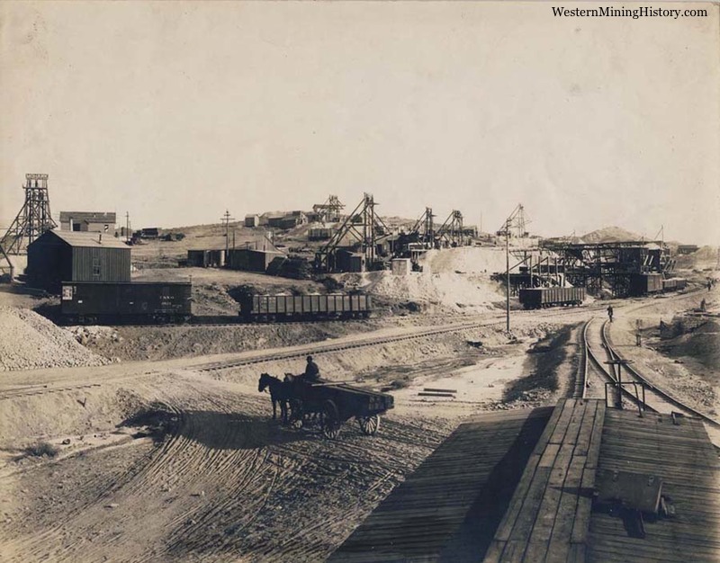
13. Battle Mountain District – Located in Humboldt and Lander Counties, this district was discovered in 1866. The lode deposits in the Battle Mountain area have been worked since 1866, but the placers apparently were not worked until 1909, when the discovery of rich gold lodes and associated placers near the mouth of Philadelphia Canyon stimulated a rush to this area, then called Bannock. Within 5 years, many of the other placers in the district were discovered and worked.
14. Argenta District – Located in Lander County, this district was discovered in 1866. Historically a silver and barite district, a major gold discovery in 1986 made this one of Nevada’s larger producers.
15. Maggie Creek District – Located in Eureka County, this district was discovered in 1875. This district is located in the Tuscarora Mountains about 11 miles northwest of the town of Carlin, and came to prominence in recent decades as part of the Carlin Trend gold belt. The Gold Quarry open pit mine is located here. Placer gold is credited to the district although production values are not known.
16. Carlin District – Located in Elko and Eureka Counties, this district was discovered in 1859. The Carlin district covers the southern end of the Tuscarora Mountains north of the town of Carlin, and the northern end of the Piñon Range immediately south of Carlin. The southeast portion of the district, in the vicinity of the Rain Gold Mine, is sometimes referred to as the Rain subdistrict of the Carlin Trend.
17. McCoy District – Located in Lander County, this district was discovered in 1914. Small placers were worked in the near vicinity of the Gold Dome mine.
18. Bullion District – Located in Lander County, on the eastern side of the Shoshone Range in T28-30N, R46-47E. The district includes Mud Springs on the north, Lander 4 miles to the south, Tenabo 2 miles southeast of Lander, Gold Acres about 5 miles southwest of Tenabo, and the Raleigh area in T28N, R47E. Placers were first worked in 1907 in the Mud Springs area of the Bullion district.
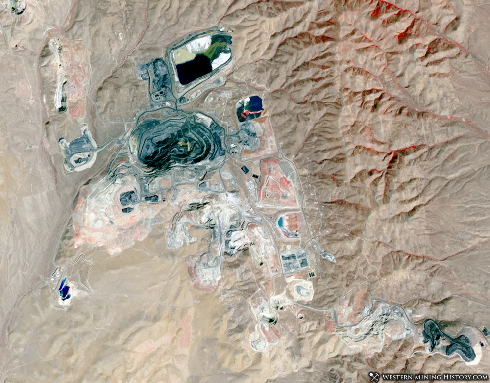
19. Cortez District – Located in Eureka and Lander Counties, this district was discovered in 1863. This is one of Nevada’s most valuable and longest operating districts. Underground mining transitioned to open pits by the 1930s. Various pits have operated here over time and large-scale mining continues today. Gold production and reserves from this district are in the tens of millions of ounces.
20. Antelope District – Located in Eureka County, this district was discovered in 1870. The district is located on the western slope of the Roberts Mountains north of Eureka, near Roberts Creek Station on the old overland road. The present district includes the western part of the Roberts Mountains and a small area in the Simpson Park Mountains in the vicinity of Tonkin Springs.
21. Bald Mountain District – Located in White Pine County, this district was discovered in 1869. The district includes both Big and Little Bald Mountain, the northeastern part of Buck Mountain, part of the Maverick Springs Range, and Alligator Ridge. Some placer production is credited to this district.
22. Comstock District – Located in Storey County, this district was discovered in 1858. The Comstock is located around Virginia City, and is one of the nation’s richest and most famous mining districts. Although this is known primarily as a silver district, over eight million ounces of gold is credited to the Comstock mines. Placer gold occurs here in Gold and Six Mile Canyons.
23. Talapoosa District – Located in Lyon County, this district was discovered in 1863. The district covers a small area of the eastern Virginia Range about 3 miles northwest of Silver Springs and 3 miles east of the Ramsey district. Minor placer gold has been recorded here.
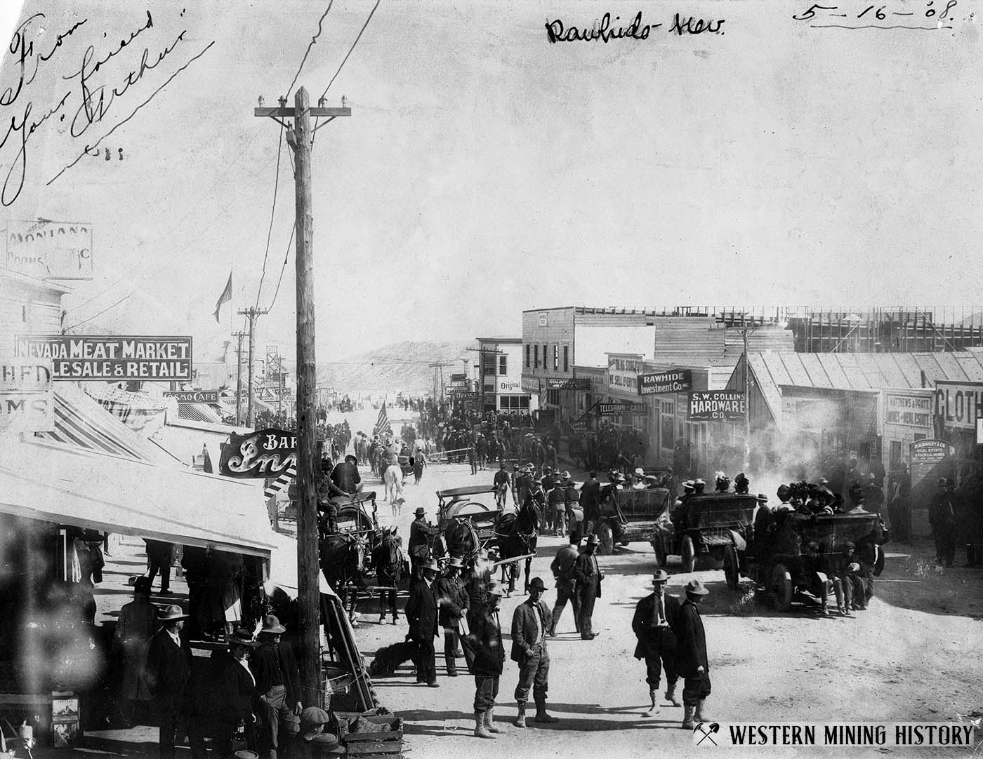
24. Rawhide District – Located in Mineral County, this district was discovered in 1906. The original Regent district was situated about 2 miles northwest of the town of Rawhide. The district became known as Rawhide when it was expanded to include discoveries made at Rawhide in 1906. Placers in the Rawhide district are found in Rawhide Wash and tributaries extending about 4 miles southeastward from the townsite of Rawhide to the alluvial fan at the base of the hills.
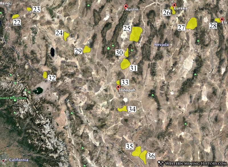
25. Northumberland District – Located in Nye County, this district was discovered in 1866. The original Northumberland district was located at the head of East Northumberland Canyon in the northern Toquima Range, but now extends north to the Lander County line. This district has been open-pit mined in recent decades and the deposit is described as “typical Carlin style mineralization”.
26. Eureka District – Located in Eureka County, this district was discovered in 1864. The district is famous as a silver-lead producer, but significant gold has been mined here. Between the peak production years of 1871-1888, and subsequent periods of mining into the 1900s, it is estimated that over 1.2 million ounces of gold were recovered. This is an active mining area and modern production figures are not included in that figure.
27. White Pine District – Located in White Pine County, this district was discovered in 1865. White Pine was an early and famous silver district. Gold was also mined here but production totals are difficult to ascertain. The publication Mining Districts of Nevada by the Nevada Bureau of Mines and Geology includes this district in the group having 1,000,000 or more ounces of gold produced or in reserve, but provides little detail.
28. Robinson District – Located in White Pine County, this district was discovered in 1864. The Robinson (also known as Ely) district is centered near the towns of Ely and Ruth, in the Egan Range. From 1902 through 1959, a total of 1,959,659 ounces of gold was extracted from the copper ores of the district.
29. Fairplay District – Located in Mineral and Nye Counties, this district was discovered in 1865. The Fairplay district includes the southern and southwestern flanks of the Paradise Range and extends from Coyote Spring/Ford Wells and the old camps of Atwood and Goldyke on the east to Finger Rock Wash, west of the Mineral County line. A small amount of placer gold was recovered in the late 1950’s from small placers in the Fairplay district.
30. Round Mountain District – Located in Nye County, this district was discovered in 1865, although new discoveries made in 1906 were the most important. Both placer and lode mines were important here. Today the Round Mountain Gold Mine is one of the state’s largest open pit mines. Round Mountain is known for the stunning specimen gold that is found here.
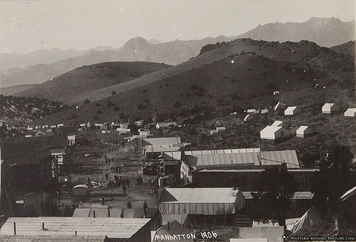
31. Manhattan District – Located in Nye County, this district was discovered in 1865 but experienced its most notable activity after new discoveries in 1905-06. From 1906 through 1921 the district produced 136,514 ounces of lode gold and 58,686 ounces of placer gold; through 1959, the total was 280,022 ounces of lode gold and 206,340 ounces of placer gold. Additional lode mining in recent decades has added to the production totals, and hundreds of thousands of ounces remain in reserve.
32. Aurora District – Located in Mineral County, this district was discovered in 1860. Aurora prospered from the 1860s until the 1880s when the high-grade ore ran out. The district experienced a few periods of revival, most notably from 1910-1920. Although data for production in the early days are incomplete, Hecla Mining Company, which owns an open pit mine that has operated in the district in recent decades, estimates that 1.9 million ounces was produced here during the early years.
33. Tonopah District – Located in Esmeralda and Nye Counties, this district was discovered in 1900. Tonopah was predominantly a silver district, but it also yielded large amounts of gold. From 1901 through 1959, a total of 1,880,000 ounces of gold was produced.
34. Goldfield District – Located in Esmeralda and Nye Counties, this district was discovered in 1902. Goldfield is one of the state’s most famous historic gold districts. Extremely rich ore discoveries resulted in the rapid development of the Goldfield camp into the state’s largest city, only to be nearly abandoned in the 1920s as the gold ran out. From 1903 through 1959 the district produced over 4,000,000 ounces of gold. Currently a large project is underway to resume mining at Goldfield.
35. Bullfrog District – Located in Nye County, this district was discovered in 1904. The district is located in the Bullfrog Hills, west of Beatty, and extends from towns of Bullfrog and Rhyolite on the south to the camp of Pioneer on the north, and from Beatty on the east to the Gold Bar and Happy Hooligan mines on the west. This was primarily a silver district, however through 1921 112,000 ounces of gold was produced. Modern open pit mines account for the bulk of the gold production in this district.
36. Bare Mountain District – Located in Nye County, this district was discovered in 1905. Also known as the Fluorine district, it lies east of Beatty and includes both Bare Mountain and the northwestern end of Yucca Mountain. The original Bare Mountain district included only the northern part of Bare Mountain, near the old camp of Telluride. Most gold production is the result of modern mining activity in recent decades.
Significant Nevada Placer Gold Districts
Eighty-two districts in Nevada are identified as having placer gold, even if very minor and with no recorded production. According to descriptions in the publication Placer Gold Deposits of Nevada – USGS Bulletin 1356, just 15 of the districts are considered significant gold producers,
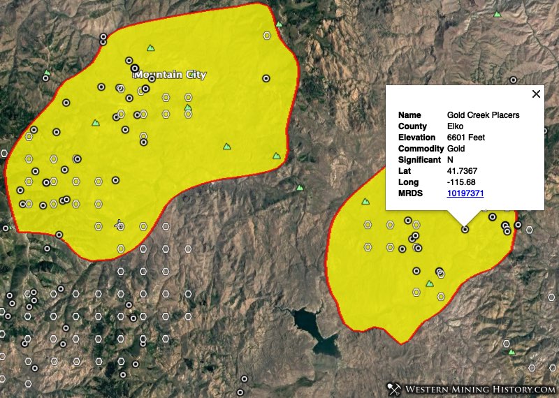
The following image illustrates the distribution of significant placer districts in the state of Nevada.
1. Mountain City District – Located in Elko County, this district was discovered in 1869. The Van Duzer district is now included as part of the Mountain City District, and is the location of most of placer gold production. The Van Duzer placers were discovered in 1893 by Rutley M. Woodward, who worked the gravels by sluicing and hydraulic methods, reportedly recovering $50,000 in placer gold in the first years following discovery. The placers have been worked sporadically in the 20th century, generally with good returns.
2. Island Mountain District – Located in Elko County, this district was discovered in 1869. The Island Mountain placers were discovered in 1873 by Emanuel Penrod, C. Rouselle, and W. Newton. Penrod and a few other miners worked the gravels by primitive methods for about 20 years before others became interested in the area. Penrod’s claims occupied most of the alluvial basin. The early production is estimated at about $800,000.
3. Tuscarora District – Located in Elko County, this district was discovered in 1867. The Tuscarora placers were discovered in 1867 by prospectors from Austin. They found gold in small quantities for 3 miles along McCann Creek. Nuggets weighing 1 ounce were commonly found in the shallow gravel. The placers have been worked only sporadically during the 20th century. The largest recovery was in 1902, 1905, and 1909; in other years, very small amounts of gold were recovered.
4. Imlay District – Located in Pershing County, this district was discovered in 1860. Also known as the Humboldt district. Substantial amounts of placer gold have been credited to the Imlay or Humboldt district between 1913 and 1951. Modern open pit mining has made this district one of the state`s more significant districts (see description above for further information).
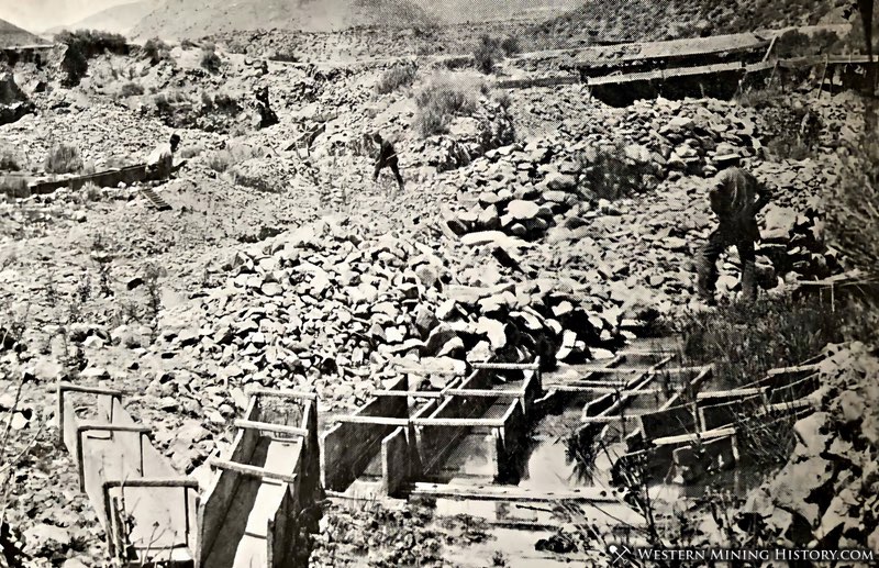
5. Sierra District – Located in Pershing County, this district was discovered in 1863. The placers in the Sierra district are among the most productive in the State, the production being estimated at $4 million before 1900. This estimate represents the amount of gold thought to have been recovered by Chinese miners, who between 1870 and 1890 reportedly recovered $2 million from Auburn and Barber Canyons and between 1880 and 1895 recovered $2 million or more from Rockhill Canyon.
6. Battle Mountain District – Located in Humboldt and Lander Counties, this district was discovered in 1866. Placers apparently were not worked until 1909, when the discovery of rich gold lodes and associated placers near the mouth of Philadelphia Canyon stimulated a rush to this area. The most productive periods were 1913-22, 1932-39, and 1947-55. Throughout these periods, the placers in Copper Canyon and in the Copper Canyon fan have been the most continuously worked and most productive deposits, but production from the other placers has been considerable.
7. Rochester District – Located in Pershing County, this district was discovered in the 1860s. Placers were worked in Sacramento, Limerick, Rochester, and Weaver Canyons on the west flank of the Humboldt Range. The placers were discovered in the early 1860’s about the same time as the lode mines and worked on a small scale. Early placer activity was apparently concentrated in Rochester Canyon, but the placer workings are now covered by mill tailings from the lode mines.
8. Spring Valley District – Located in Pershing County, this district was discovered in 1868. The placers in the Spring Valley district are said to be the most productive in Nevada. Placer production estimated to be as much as $10 million, largely from American and Spring Valley Canyons, is attributed to early work by Chinese placer miners.
9. Olinghouse District – Located in Washoe County, this district was discovered in 1860. The placers in the Olinghouse district were extensively worked between 1860 and 1900 and were said to produce considerable gold, but no authentic records of placer gold production are known. The total placer and lode-gold production of the district before 1900 has been estimated at about $218,000, although some estimates indicate as much as $500,000. During the 20th century, the Olinghouse placers have been worked almost continuously, but mostly on a small scale.
10. Comstock District – Located in Storey County, this district was discovered in 1858. Placer gold was recovered from the Comstock district during the initial prospecting stage (about 1857-59) in this famous lode-mining area. Decomposed ores of the Sierra Nevada mine, near Seven Mile Canyon, tributary to Six Mile Canyon, were mined by placer methods during the 1860’s. Placering during the 20th century is reported for the period 1934-47, but, except for the year 1934, when 354 ounces of gold was recovered by two operators, yearly production was very small.
11. Silver City District – Located in Lyon County, this district was discovered in 1849. Also known as Gold Canyon, this is the state’s oldest gold district. A detailed account, The Gold Canon Placer Mining Colony, was published on the early history of this district. Much has been written about Gold Canyon, for more information check out the linked articles.
12. Round Mountain District – Located in Nye County, this district was discovered in 1865 although new discoveries made in 1906 were the most important. Both placer and lode mines were important here. The placers were still being worked, on a fairly large scale, in the early 1950’s by the Round Mountain Gold Dredging Corp. The placer mines are described as “the most productive in the State during the 1900’s, are remarkable for the large production yielded for the small area in which they are found.”
13. Manhattan District – Located in Nye County, this district was discovered in 1865 but experienced its most notable activity after new discoveries in 1906. The placers in the Manhattan district were discovered in 1906 and have been the second most productive in the State during this century. The most productive epoch in placer mining at Manhattan occurred between 1938 and 1946, when the Manhattan Gold Dredging Co., a subsidiary of Natomas Co. operated a floating bucket-line dredge which had 108 9 1/2 cubic foot buckets in Manhattan Gulch.
14. Osceola District – Located in White Pine County, this district was discovered in 1872. Since the discovery of the Osceola placers in 1877, placer mining has continued in the district with different methods and intensity. In the decades following the discovery, hydraulic placer mining was successful at Dry Gulch. During the late 1930’s, hydraulic mining at the Hampton placer in Dry Gulch that had been hydraulicked in the early days produced the highest yearly total of placer gold recorded for the district. Large nuggets have been recovered here, including 125 and 53 ounce nuggets in 1892.
15. Lida District – Located in Esmeralda County, this district was discovered in 1871. Note that Lida and Tule Canyon districts are often described as one district, but here they are broken into two districts. The Placer description is included in the Tule Canyon record. Early in the history of the district, the area was mined extensively by Chinese placer miners, who recovered large amounts of gold—estimated by some writers at more than $1 million, although no real evidence exists to support this claim of high gold recoveries. During the 20th century, the placers have been worked continuously, although on a small scale.
Where’s the Gold?
Other articles on this site that look at the distribution of gold districts within states are usually in the format of the Where to Find Gold series – example Where to Find Gold in California. These articles are based on data from the WMH Gold Maps, however there is no gold map product for Nevada.
The reason for this is that Nevada has always been primarily a lode-mining state, and unlike the placer districts in other states that accounted for a high percentage of gold production, Nevada’s placer mines ultimately pale in comparison to the gold output of the lode mines, especially when considering the production from modern open-pit mines. Due to this, and to the prevalence of placer mining claims covering large areas for the purpose of mining evaporite minerals, the type of analysis done for the WMH Gold Maps just doesn’t work very well for the state of Nevada.
As an added complication, with gold mining being big business in Nevada, many historical gold districts are completely tied up with both lode and placer mining claims, so finding open ground to prospect on can be difficult.
That doesn’t mean that placer gold can’t be found in Nevada, in fact the state is known as a good place to find nuggets, especially with metal detectors as the lack of water makes placer mining methods difficult. It’s just going to take more research to find areas with good placer gold potential that aren’t already claimed. The WMH Nevada Mining Atlas and the WMH Claims Research Tools are good tools to use to get started on this research.
Related: Mining Districts of Nevada