WMH Gold Maps for Google Earth Pro are designed to locate areas with high potential for finding placer gold. A core feature of these maps is the highlighting of townships that contain both active placer mining claims and historical gold mines.
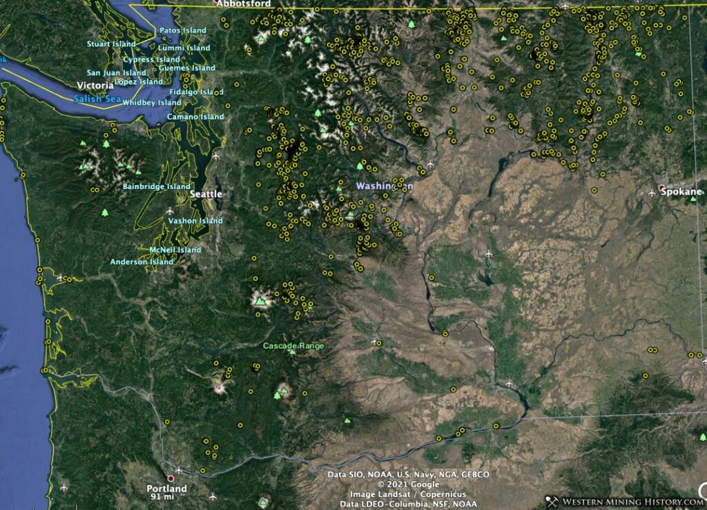
The screenshot below uses data from the Washington Gold Map and shows gold-bearing PLSS townships across the state (this view was created with Google My Maps). The highest concentration of gold rich areas is in the central part of the state, particularly in Kittitas and Snohomish counties.

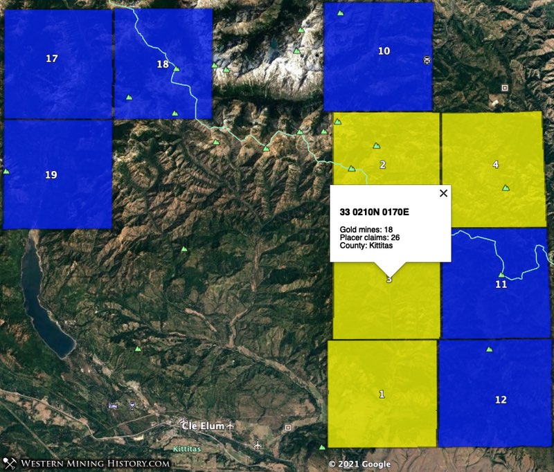
Townships that contain both active placer claims and historical gold mine records are shaded in one of the following colors based on how many active placer claims are in the township: 1 – 10 claims: blue; 10 – 50 claims: yellow.
Additional images in this article will contain more data points. Yellow circles are gold mines, hexagonal markers are PLSS sections that contain active placer mining claims, and blue markers with pick axes are district locations.
In this analysis we will be looking at the gold townships highlighted by the WMH Washington Gold Map and identifying which have the highest potential for gold discovery.
Township PLSS numbers cited in this article are in the same format used in the BLM MLRS application, and can be copied and pasted directly into the MLRS search form.
Related: Researching Mining Claims with the BLM MLRS
The following list summarizes the top gold townships in Washington as ranked by the WMH Washington Gold Map.
Note: there is an anomalous result in Stevens County, west of the town of Valley. The Gold Map identifies township 33 0310N 0390E as having the eighth highest placer claim density in the state, but this seems to be associated with surface mining of silica minerals, not for gold.
1. Kittitas County – Swauk District (Liberty)
Gold was discovered in this part of Washington state in 1868, making it one of the state’s oldest gold locations. The settlement of Liberty, established in 1873, is said to be the oldest mining town in the state.
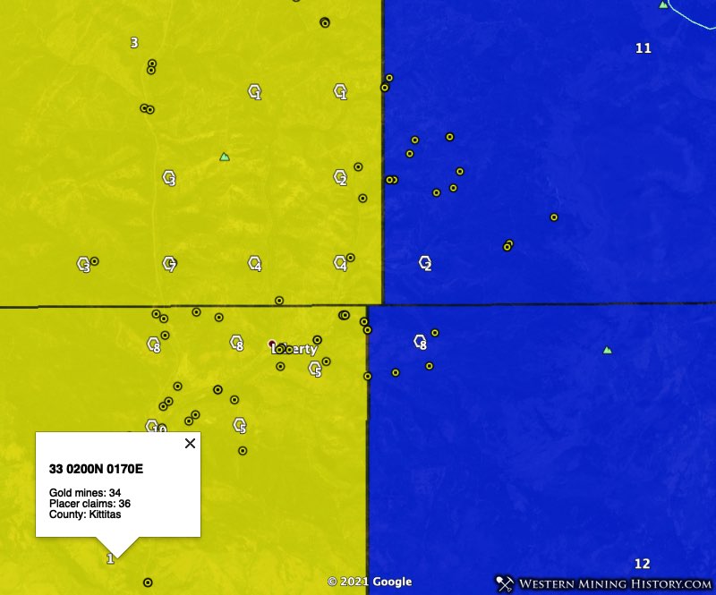
The top placer gold producing township in the state of Washington is 33 0200N 0170E (36 placer claims, 34 gold mines). Most of the active gold mining areas are in the northeast part of the township around the town of Liberty.
North of Liberty, township 33 0210N 0170E (26 placer claims, 18 gold mines) ranks third in the state. East and northeast of Liberty, seen in blue in the image above, townships 33 0210N 0180E (9 placer claims, 24 gold mines) and 33 0200N 0180E (8 placer claims, 6 gold mines) rank 11th and 12th respectively.
Almost no records exist of early gold production in this district, so the total amount of gold mined here is unknown. What is known is that in recent years this district has more active placer claims than any other location in Washington.
The USGS reports “The only gold deposits in Kittitas County that have yielded 10,000 ounces or more are those of the Swauk district…….. Production before 1903 is unrecorded, but there is an 11-year record from 1884 to 1895 which credited the county with $764,163 worth of gold (37,095 ounces).”
2. Chelan County – Blewett District
The USGS summarizes the Blewitt district as follows:
“Rich gold placers were discovered on Peshastin Creek in 1860 and were worked intermittently for several years. In 1874 vein deposits were found in Culver Gulch. For many years only the oxidized parts of the veins were mined, but in the late 1890’s extensive development revealed new and rich ore bodies and for a while the district prospered. After 1910, however, there was only small-scale activity. Total production from 1870 to 1959 was approximately 850,900 ounces.“
Thew Blewett district is approximately 12 miles north of the Swauk district and remains one Washington’s top placer gold locations.
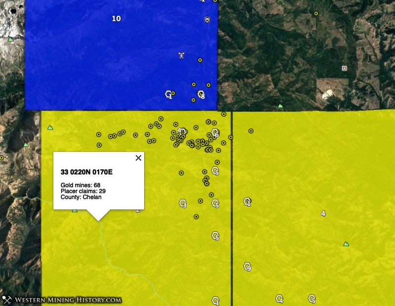
Township 33 0220N 0170E has 29 active placer claims and 68 USGS gold mine records, making it the second ranked gold township in the state. To the east, neighboring township 33 0220N 0180E (19 placer claims, 2 gold mines) ranks fourth. To the north, township 33 0230N 0170E (10 placer claims, 8 gold mines) ranks tenth.
A 1911 report by the Washington Geological Survey included the following information on the Blewett placer deposits:
“The richest and most extensive deposits occur north of Blewett on the Peshastin, near the mouth of Negro [now called Etienne] creek. These gravels were originally derived from the upward extension of the present quartz veins in this district, by the erosive action of the smaller gulches and creeks emptying into Peshastin and Negro creeks. These old channels occupy in a general way the trend of the present valleys but do not always conform to the present winding of these streams.”
“The placer gravels vary in thickness and character and may be divided into two groups, one representing the gravels as they were originally deposited, and the second those that have been worked over by the present streams. The former comprise the bench gravels and a part of those lying next to bed-rock; the latter, those gravels on a general level of the present creek beds. In general the older gravels contain the richest deposits of gold. Through these the gold is pretty evenly distributed. but is richest close to bed-rock. Where the bed-rock is composed of slate many crevices and water-worn pot holes contain exceptionally rich deposits of gold.”
3. Snohomish County – Sultan Basin District
The Sultan Basin district is on the western flank of the Cascade Range, North of the town of Sultan. The USGS publication Principle Gold Producing Districts of the United States only gives this district a brief mention, and discounts it as an area of significant gold production.
The Sultan Basin district was first prospected in the 1870s, but the area’s remoteness and rugged terrain resulted in no major mining activity until the 1890s. The 1945 publication Geology and Ore Deposits of the Sultan Basin by the Washington Department of Mines and Geology states “None of the mines of the Sultan Basin has had more than a brief or sporadic record of production.”
Despite the district not having a strong history of gold production, today it is one of the state’s most active placer mining areas.
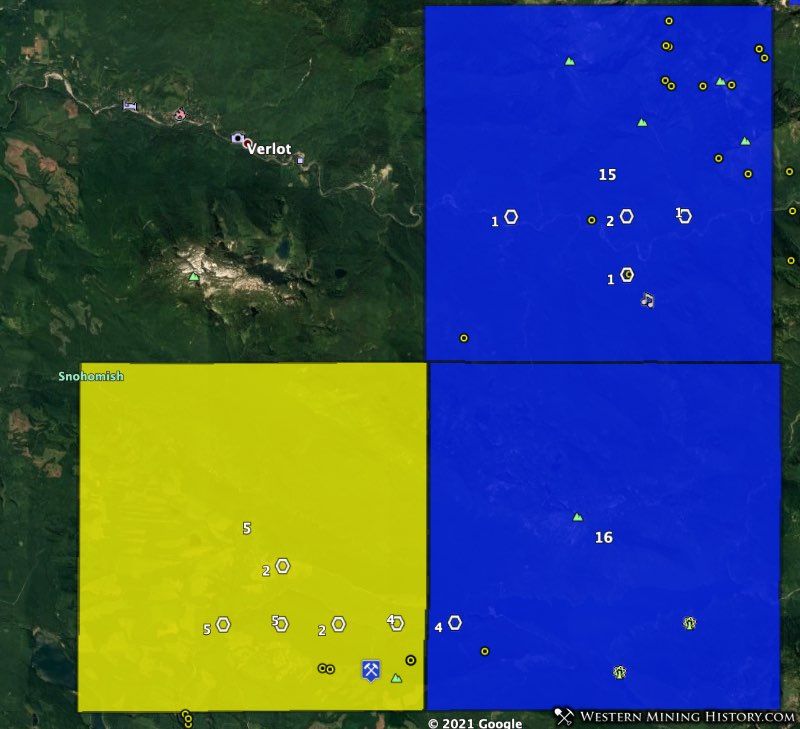
Township 33 0290N 0080E has 18 active placer claims and 5 USGS gold mine records, making it the fifth ranked gold township in the state. To the east and northeast, townships 33 0300N 0090E (5 placer claims, 15 gold mines) and 33 0290N 0090E (4 placer claims, 1 gold mines) rank 15th and 16th respectively.
4. Whatcom County – Slate Creek District
The Slate Creek district is in the eastern part of Whatcom County, in the heart of the Cascade Range.
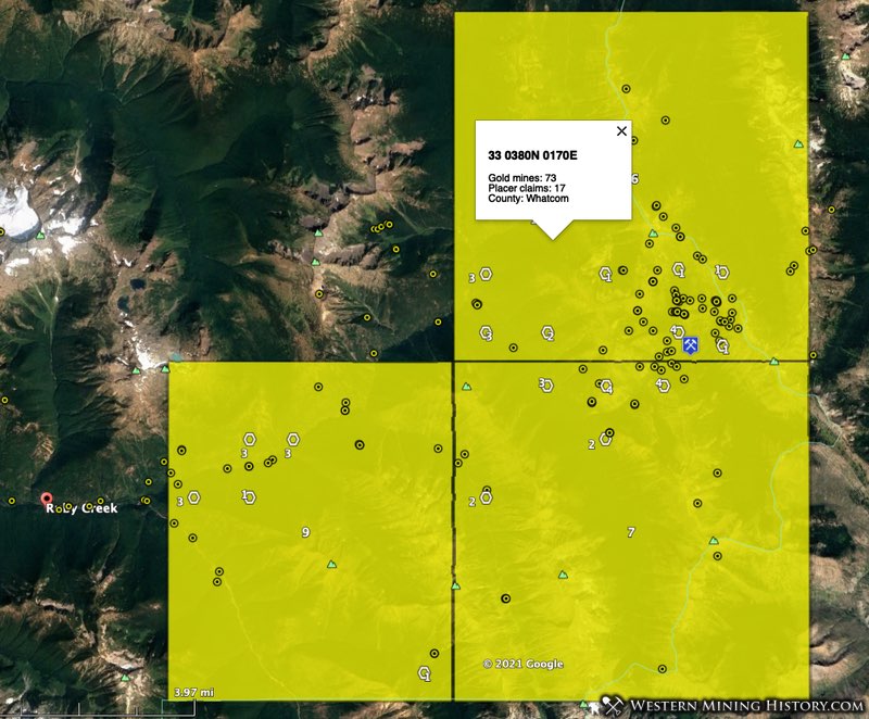
Township 33 0380N 0170E has 17 active placer claims and 73 USGS gold mine records, making it the sixth ranked gold township in the state. To the south and southwest, townships 33 0370N 0170E (15 placer claims, 26 gold mines) and 33 0370N 0160E (11 placer claims, 23 gold mines) rank 7th and 9th respectively.
The 1969 publication Mines and Mineral Deposits of Whatcom County by the Washington Department of Mines and Geology summarizes the early history of the district:
“Placer mining has been carried on in the district since the late 1870’s, but the operations have been small and sporadic. Credit for the discovery of placer gold is given to a man named Rowley. At Rowley Chasm on Ruby Creek-about three-quarters of a mile downstream from Boulder Creek-Rowley discovered coarse gold nuggets in the south bank of Ruby Creek. As a result of his discovery, over $100,000 in gold was supposed to have been recovered by Rowley and other prospectors.”
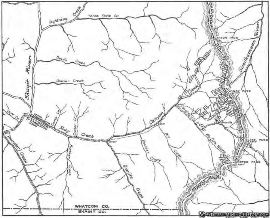
The above image is a claim map from 1899 and shows claim distribution that is similar to what is revealed by the images from the WMH Washington Gold Map.
5. Skamania County – St. Helens District
Although parts of the St. Helens district was mined for placer gold, the production of placer gold from the district has been insignificant. The district is approximately 13 miles (as the crow files) southeast of the town of Randle.
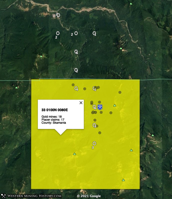
Township 33 0100N 0080E has 17 active placer claims and 18 USGS gold mine records, tying it for the sixth ranked gold township in the state. An unusual result here is that the township to the north, 33 0110N 0080E, has 15 active placer claims but no historical gold mine records.
The 1977 publication St. Helens and Washougal Mining Districts of the Southern Cascades of Washington by the Washington Department of Natural Resources, Division of Geology and Earth Resources includes some text that provides clues as to where placer gold may be found today in unclaimed areas adjacent to this district:
East of the St. Helens district claims were staked on deposits of lode and placer gold at the turn of the century. The most productive area proved to be the upper reaches of McCoy Creek, which yielded small amounts of placer gold in the early 1900’s and in the depression years of the 1930’s. Discovery of placer gold on McCoy Creek led to the discovery of lode gold on Camp Creek, a tributary to McCoy.
From 1934 to 1940, the Camp Creek mines produced minor gold from small high-grade deposits that had been discovered in the early 1920’s. Since 1940, the McCoy Creek area has been nonproductive. Several streams other than McCoy Creek yielded placer gold; however, all deposits proved to be small and non-commercial.
6. Okanogan County – Oroville, Nighthawk Districts
Some of the most active gold mining areas in Washington are found at the extreme northern end of the state, directly adjacent to the Canadian Border. The town of Oroville sits just to the east of several notable gold areas, including the Nighthawk and Oroville districts.
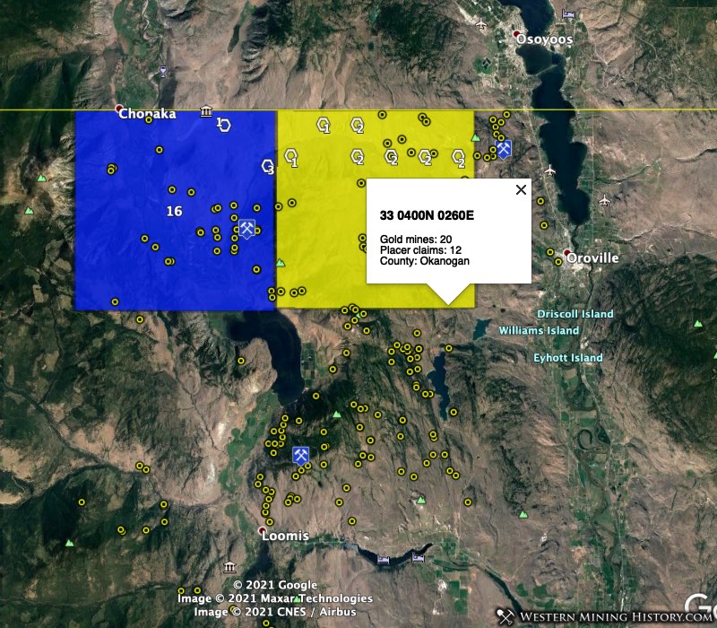
In the Oroville district, Township 33 0400N 0260E has 12 active placer claims and 20 USGS gold mine records, making it the eighth ranked gold township in the state. To the west, in the Nighthawk district, township 33 0400N 0250E (4 placer claims, 33 gold mines).
Details on these districts are difficult to find, but the numerous USGS gold mine records indicate this is one of the state’s more important gold regions.
Other Washington Placer Gold Locations
This list looks at some of the top placer gold locations in Washington, but it is hardly complete. The Washington Gold Map identifies many areas throughout the state where active placer claims and historical gold mines are present. Many of these are little known and have not had much history recorded about them.
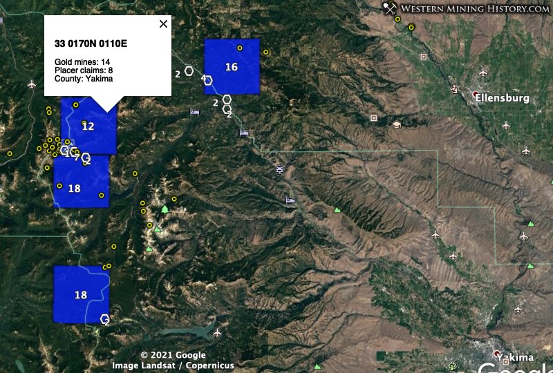
The Summit district in western Yakima County has active placer claims and numerous historical gold mines.
The Money Creek and Monte Cristo mining districts in Snohomish County have active placer claims.
The Orient district, in Stevens County, is known as a lode mining district, but has some active placer claims.
While Washington is not one of the nation’s top gold-producing states, and the gold mines here have primarily been lode producers, potential for placer gold discovery still exists in many areas. The image below illustrates the distribution of all USGS gold mine records for the state of Washington.
Conclusion
While it is illegal to mine or prospect for gold on an established mining claims, there is still a lot of unclaimed ground, even in historically important mining areas.
Using the Washington Gold Map, areas with high gold potential can be quickly identified and used as the basis for additional research. Prospectors can focus on the most active placer gold areas and attempt to discover their own claim, or they can look at those areas on the map that have many historical gold mines and few claims in an attempt to stake a claim in an area with less competition.
Notes on the Data Used in this Analysis
While the methods used here allow for a quick overview of all potential gold areas in the state, they are not perfect. Occasionaly some historical gold mines will be located near modern surface mining operations for things like evaporite minerals, and the the correlation between active placer claims and the adjacent historical gold mines are coincidental only and do not indicate an area with strong gold potential.
Claim counts were created using BLM active placer claim data distributed on August 1, 2020.
Gold mine numbers cited for each township are the number of USGS records, some of which are duplicates.