The Mount Baker district is located in Whatcom County, Washington. The following overview is part of the 1969 publication Mines and Minerals of Whatcom County, Washington by the Washington Department of Natural Resources, Division of Mines & Geology.
Mount Baker Mining District
The Mount Baker mining district, which was established in 1898 at a miners' meeting in Sumas, is delineated as follows:
Beginning at the northwest corner of the town of Sumas, and thence running due south to a point clue west of the summit of Mt. Baker; thence east over the summit of Mt. Baker to the Skagit River; then following that stream in a northerly direction to the Canadian Border, from whence it extended due west along the Boundary Line to the point of beginning. (Jeffcott, 1963, p. 119.)
Prior to 1898 the area north of Mount Baker was most commonly referred to as the Mount Baker or Nooksack mining district. The area southeast of Mount Baker was known as the Baker Lake mining district.
Mining History
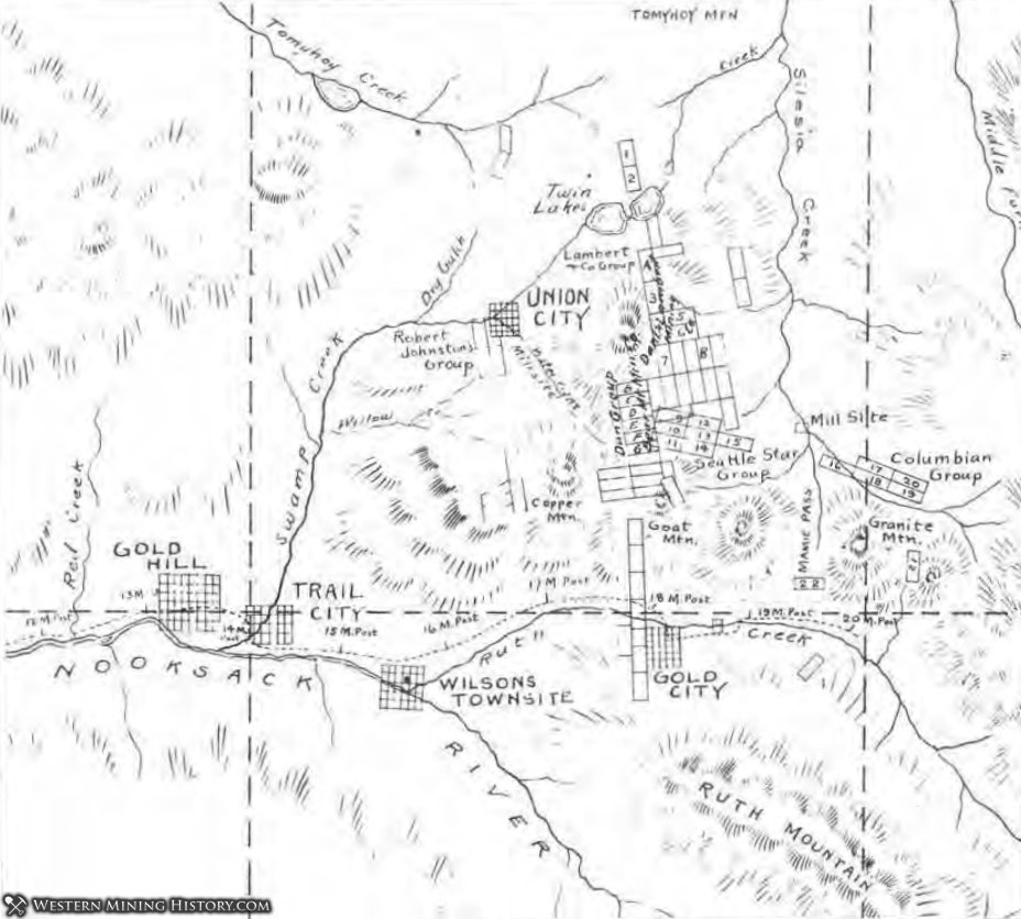
The mining history of the county from 1852 to 1897 -the year of the Lone Jack discovery-has been discussed on pages 10 through 12 of this report. A map of the Mount Baker mining district as it appeared soon after the discovery of the Lone Jack mine is shown in Figure 24.
As would be expected, the discovery of visible gold in the Lone Jack lode attracted many prospectors. Claim staking increased in the area of Twin Lakes, near the Lone Jack discovery, and spread outward in the directions of Red Mountain, Tomyhoi Peak, Goat Mountain, and along the drainage of Silesia Creek. Extensive prospecting resulted in the second most important find of the district, which was the discovery of the Boundary Red Mountain lode in the summer of 1898.
At this time C. W. Roth and party staked and recorded the Klondike and Climax claims, which are on the northern slope of Red Mountain, half a mile south of the Canadian border. The Red Mountain Gold Mining Co. was organized in 1900, and the company staked the Rocky Draw, Glacier, and Climax Extension No. 1 claims. As prospecting and staking of lode claims continued in the district, placer claims were staked along the Nooksack River and on Ruth, Swamp, and Silesia Creeks. However, the placer gold occurred mainly as dust, and nuggets were rare; all placer operations were small.
In 1901 Wm. Boyd and W. L. Martin located the Gold Run claim on the southern slope of Red Mountain; this claim later became the site of the Gargett mine. In the same year, L. A. Price and party staked the Saginaw claims northeast of Twin Lakes. At the Lone Jack mine a 15-stamp amalgamation mill had been constructed near Silesia Creek and a 4,000-foot aerial tram moved gold ore from mine to mill.
In 1904 the Evergreen claim, near the headwaters of Swamp Creek, was staked by the Blonden brothers. Earlier, in 1900 and 1901, to the south of the Evergreen and near the summit of Goat Mountain, G. C. and R. 0. Blonden had discovered several quartz veins that carried free gold. In 1904 the Mount Baker-Shuksan Mining Co. was actively engaged in developing the Red Crest claim on Damfino Creek, 4 miles west of Twin Lakes. Along the banks of the creek, tunnels were driven on gold, silver, and copper discoveries that had been made by G. B. Conway in 1900.
On Wells Creek, which is about 10 miles southwest of the Lone Jack mine, the Great Excelsior Mining Co. located and filed upon the Great Excelsior group in 1901, and by 1903 had placed a 20-stamp mill in operation and was shipping gold-silver concentrates to the Tacoma smelter. About this time, on the extreme western edge of the Mount Baker mining district, near Sumas, the Nooksack mine had put a 12-stamp mill into operation and was producing gold concentrates.
At the Boundary Red Mountain mine, mining and milling were carried out on a small scale until 1915, at which time George Wingfield, of Nevada, acquired the property and constructed a 10-stamp amalgamation mill. In 1916, milling operations began and gold bullion was shipped from the mine. Also in 1916, the Great Excelsior mine ceased operations on Wells Creek because of low mill recoveries and poor mineral values. Earlier, in 1908, the Nooksack mine had shut down for the same reason.
Although most prospecting and mining was in the area north of Mount Baker, a few prospectors explored the county north of Baker Lake and east of Mount Baker. Claims were staked along Swift, Shuksan, and Sulphide Creeks, as well as other tributaries of the Baker River. The most well-known prospector of this area was Joseph Morovits, who in 1891 homesteaded near the confluence of Swift Creek and the Baker River.
In 1908 Morovits and other members of his party located and filed upon the Fourth of July group of claims, near the headwaters of Swift Creek. Although Morovits had filed upon other claims in the area, it was at the Fourth of July mine that he under- took the greatest amount of work. Almost single-handed he moved a stamp mill from Birdsview, near Concrete, over 21 miles of trail to the millsite on Swift Creek (Connelly, 1957, p. 4). However, insufficient ore was found to keep the mill in operation, and mining ceased around 1912.
Production of gold continued sporadically until 1924 at the Lone Jack mine and until 1942 at the Boundary Red Mountain mine. During this time the gold production at the Boundary Red Mountain mine amounted to about $950,000; the Lone Jack mine had produced about $550,000. Other gold producers were the Gargett, Gold Basin, and Blonden mines; however, the combined production from these three mines proba1y did not exceed $25,000.
Whatcom County records show that from 1890 to 1937 more than 5,000 mining claims were staked in the Mount Baker mining district. By 1937 the furor over gold no longer existed, and only a few diehard prospectors remained. In 1938 a small flotation mill was erected at the Evergreen mine by Evergreen Mines, Inc. Unlike other mines in the area, which were mined mainly for gold, the Evergreen ore contained galena and sphalerite. However, after operating one year the mine shut down, mainly because of insufficient ore to keep the mill in operation.
At the Silver Tip mine, which had been discovered in 1896, little in the way of mining had been under- taken. A few short tunnels had been driven on several silver-lead-copper veins, but no attempt had been made to develop the property into a producing mine. In 1938 the Silver Tip Mining Company Inc. was formed, and in 1945 a small flotation mill was constructed on the property. Small shipments of concentrates and ore were made to the Tacoma smelter, but during the winter of 1949-1950 the mill was destroyed by a snowslide.
In 1949 the road to the Twin Lakes area of the Mount Baker mining district. extended from Shuksan up Swamp Creek for 4.8 miles to the Tomyhoi Lake trail. At this time, construction of a mine-to-market road to Twin Lakes was begun from the end of the existing road; it was completed to the lakes in 1950. However, by then the metal mines of the area were no longer in operation and most prospectors had left the district.
The last shipment of ore from the area was made in 1951, when the Glacier Mining Co. shipped 4112 tons of copper ore from the Midas mine, which is half a mile east of Glacier. The shipment brought the total metal production of the district to about $1,425,000, most of which production was of gold.
During the uranium rush of 1953 to 1957, prospectors once again searched the Mount Baker mining district. Areas of anomalous radioactivity were discovered on Coal Creek near Glacier and along Ruth Creek east of Shuksan; however, no significant uranium discoveries were made.
Elsewhere in the district and outside the boundaries of the Mount Baker National Forest, attempts were made to develop other metallic mineral deposits. In 1930 chromite was discovered on the north end of Sumas Mountain, and in 1946 the Super Chrome Co., of Seattle, began development of the deposit. The operations were suspended several years later, when the chromite was found to occur only as small lenticular bodies.
On the western slope of Sumas Mountain, south of the Nooksack mine, J. C. Compton and J. A. Hatton staked claims for iron in 1915. In 1938 the Hematite Iron and Gold Mines Development Co., of Seattle, acquired the property and began development work. Several short tunnels were driven and much rock sampled, but no production resulted. In the years that followed, several other mining companies examined the deposit and arrived at the same conclusion- that the deposit contained a small tonnage of low-grade material, which would make mining impractical.
Along Bells Creek, on the southern end of Sumas Mountain, placer gold was discovered in the early 1900's. In the depression years of the 1930's, several attempts were made to recover this gold; however, the scarcity of the gold made mining impractical.
In the late 1800's, copper float was found along Boulder Creek east of Maple Falls, but the source of the float was never discovered. In the early 1940's the Howe Sound Mining Co. explored the area but failed to discover a copper deposit that would justify a mining operation.
At present (1966) the mining of metallic minerals in the district is at a standstill. Most of the work on the claims is in the form of annual assessment work, but some exploration work has been undertaken to evaluate new discoveries. At the Boundary Red Moun- tain, Saginaw, and Lone Jack mines, which are patented mining claims, the owners are waiting for a rise in the price of gold.