Allens Park District
This is a small district about eight miles north of Ward. Mines listed by Dunn (2003) are the Snowbank, Tiger and Vulcan. Lovering and Goddard (1950) describe low-grade gold and silver ore in hematitic silicified breccia reefs associated with the Silver Plume Granite. The ore value was enhanced in the oxidized zone. At one location, cobalt ore was reported, although none was ever recovered. No activity was reported after 1901.
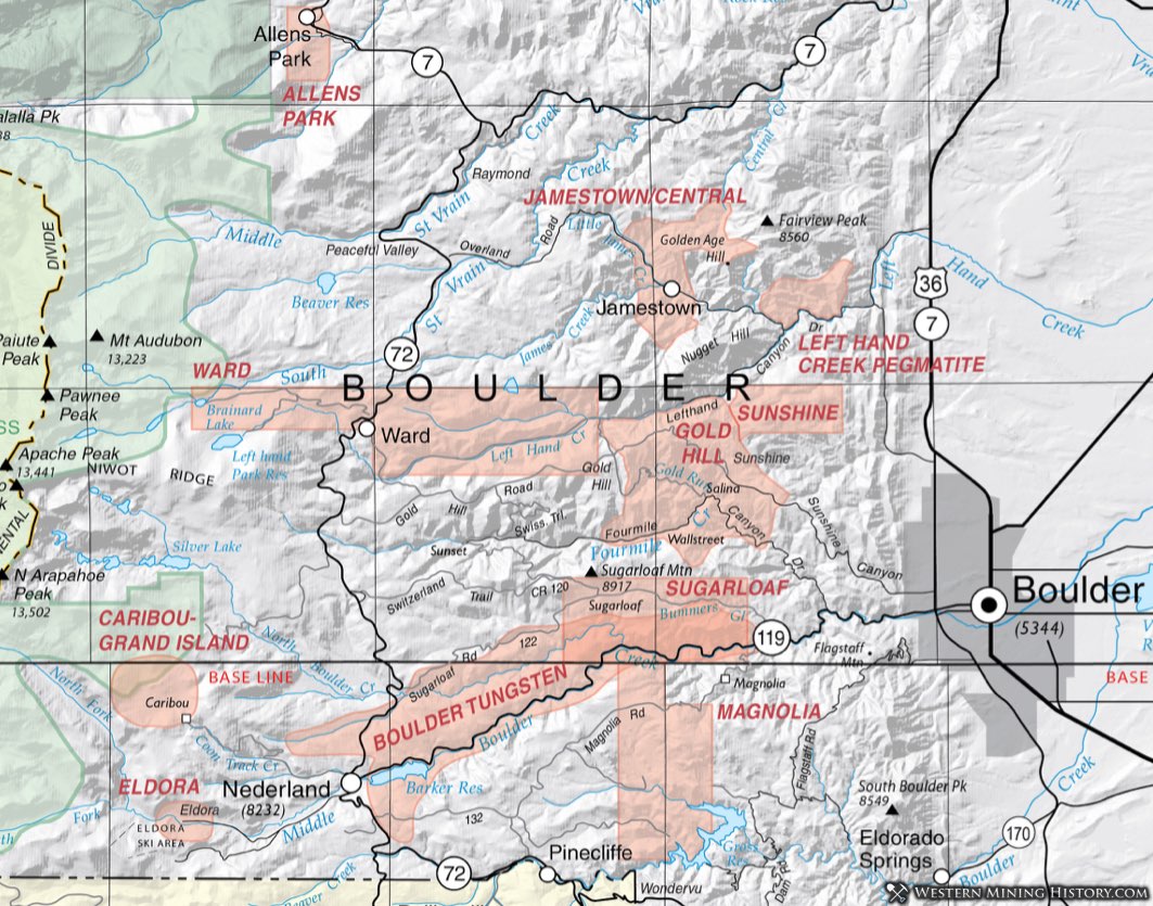
Boulder Tungsten District
The story of development of the Boulder Tungsten District is not unlike that of other areas where lesser-known commodities were mined. As prospectors combed the hills west of Boulder in search of gold and silver, they encountered rocks of a heavy black mineral they called "heavy iron," "barren silver," or "black iron." Again, as so often was the case, prospector after prospector had the rocks assayed, but it always showed to contain no silver or gold. (Mindat.org; accessed 11 July 2012.)
In 1899, a miner/prospector/developer with experience in Arizona, where he had encountered ferberite-bearing tungsten ore in the Dragoon Mountains. Some sources attribute this to W.H. Wanamaker, others to S.T. Conger. In either case, the two ultimately became partners and initiated the development of the Boulder Tungsten Belt. Wanamaker removed 40 tons of high-grade ore in 1900 (Lovering and Goddard, 1950). Conger discovered the most productive vein system in the belt - the Conger Vein.
These developments in Boulder coincided with the introduction of tungsten alloy for cutting tools. The value of the product of the district was greatly enhanced as World War I proceeded. The U.S. military recognized the superiority of German armor-plating and armor-piercing projectiles. The secret of their hardened steel turned out to be tungsten (Pittsburgh Press, 1 March 1914, accessed on news.google.com/newspapers, 11 July 2012). Boulder County soon became the leading tungsten producer in the country, and remained so until larger deposits were discovered in Nevada and California (Voynick, 1994). Peak production was in 1917.
The Tungsten Belt overlaps several other mining districts, including the Magnolia, Ward, Gold Hill and Jamestown Districts. The belt reaches from Arkansas Mountain (4 miles west of Boulder) to Sherwood Flats (1 mile northwest of Nederland.) George (1916) noted that promising prospects were being discovered in Gilpin County that would extend the Tungsten Belt to the southwest, but those apparently never developed.
The primary ore in Boulder was ferberite, an iron tungstate (FeWO4). Ferberite is the iron end-member of a solid solution series with hubnerite (MnWO4). The ferberite occurs in fissure veins with quartz; the ferberite is usually minute grains in fine-grained quartz. Tweto (1947) described the veins as Boulder Creek monzonite in the schist and quartzite of the Idaho Springs Formation. Some coarsely crystalline ferberite occurs in breccia. The occurrence is that of rich irregularly- shaped ore shoots (6 inches to 3 feet thick) separated by barren stretches. According to Sharps (1965) no ore has been found that exceeds 600 feet in depth.
Mineralogy of the ore includes in addition to the ferberite and quartz, hematite, magnetite, fluorite, dickite, ankerite, barite, siderite, adularia, scheelite , opal and various clays. According to Voynick (1994), more than a hundred tungsten mines were developed, with 30 considered significant producers. There were five active mills by the end of WWI (George, 1916). Some small production continued until the 1970s. The Eureka Mine had reopened in 1967 and continued some production until 1971 (Blake, 1971). The Tungsten, Marion, Good Friday and Eureka Mines remained active as tungsten mines through the 1970s (Blake 1979.)
Caribou-Grand Island District
In the fall of 1858, prospectors swarmed into the Boulder County area. Placer gold was discovered in Gold Run, leading to the Caribou-Grand Island District becoming the first named district in Colorado on March 7, 1859. It started out as the Mountain District Number 1 of Nebraska. Samuel Conger is credited with the first lode gold discovery in July of 1864 on the south flank of Caribou Hill. Conger also discovered silver southeast of Arapahoe Peak in the early 1860s (Kemp, 1960).
Most of the mines were closed in 1893 after the silver crash of 1893. Even at its peak, the mines of the Caribou-Grand Island District were not prolific producers. Mine production decreased even further as they went deeper (Moore, et al, 1957).
Lovering and Goddard (1950) associated the mineralization to the Caribou Stock, a composite porphyry intrusive consisting of gabbro, monzonite, quartz monzonite. The deposits consisted of veins of galena, argentite, silver halides, native silver and chalcopyrite in a largely quartz gangue. Uraninite (pitchblende) was discovered in the Caribou Mine in 1948 and the mine reopened to access that resource. Eight bodies of titaniferous magnetite, presumably of magmatic origin, occur in the Caribou Hill area. Noted by Bastin and Hill (1917) and Lovering and Goddard (1950), Harrer and Tesch (1959) estimated that they are too titantium-rich for use as iron ore.
Eldora District
The Eldora District is a small district of roughly 3 square miles 3 miles West of Nederland. Gold was discovered in 1896 and the district was a minor producer of gold tellurides and some silver. A two-year boom began in the summer of 1897 with the discovery of the gold tellurides on Spencer Mountain. Talk was that the Eldora discovery would be "another Cripple Creek" (Kemp, 1960). The deposits turned out to be small telluride stringers and masses of gold-bearing sulfides and the boom was short-lived. Eldorado Camp became the town of Eldora.
The country rock is schist of the Idaho Springs formation with a hornblende monzonite porphyry, very similar to the nearby Caribou and Grand Island Districts.
Mineralogy is mainly sylvite and petzite with a gangue of quartz, roscoelite and barite. Molybdenite is ubiquitous but minor. The Mogul and Swathmore Tunnels are the main mines. The mines were developed in the Norway, Ma W, Revenge and Enterprise veins.
Gold Hill (Sunshine, Sugarloaf) District
Mining in the Gold Hill District was set off by placer discoveries starting in December of 1859. Lode gold was discovered the following summer and the district grew as thousands of miners moved in. The rush didn't last long, and scaled back Mining was rejuvenated by the discovery of gold tellurides in 1872. Later bursts of activity occurred in 1898 (when a railroad was completed between Boulder and Ward) and in 1934. Nearly all mining ended by 1942.
The district covers roughly 12 square miles west of Boulder. Included is the Sugarloaf District. The towns of Gold Hill, Rowena, Glendale, Sunshine, Wallstreet, Salina and Crisman populated the area. A hundred mines appear on plate 23 in Lovering and Goddard (1950), indicating the intense prospecting and mining that occurred in the district through the years.
The best figures for production include the Sugarloaf District (which mostly lies within the boundaries of the Gold Hill District), indicate ore production of 706,293 tons with about $78 million at the time. Aggregated estimates from Vanderwilt (1947), Del Rio (1960) and Lovering and Goddard (1950), the combined Gold Hill/Sugarloaf Districts produced at least 690,000 ounces of gold from 1859 to 1980. From Vanderwilt (1947), during the period 1932 to 1945, the district produced 244,391 ounces of silver, 536,630 pounds of copper, 995,080 pounds of lead and 76,700 pounds of zinc.
The production has always been from fissure veins, mostly 5-feet in width, but up to 15-feet. Nearly all the important veins occur near breccia zones. Seracitic wallrock alteration is characteristic. Del Rio (1960) stated that exploration indicates that mineralization does not extend much beyond 1000 feet in depth. Few mines reached depths greater than 500 feet.
Ore grades ranged from 1 to 10 ounces of silver and 1/2 to 2 ounces of gold per ton. Gold tellurides have been the most important with petzite(Ag3AuTe3), sylvanite ([Au,Ag]2Te4), calaverite/krennerite (AuTe2)/([AuAg]Te2), hessite (Ag2Te) and altaite (PbTe) present along with native gold. Subordinate sphalerite , galena, auriferous pyrite, auriferous chalcopyrite, and tennanite (copper arsenic sulfide) also occurred.
While gold was the main focus, and silver very important, the Boulder Tungsten Belt runs through the Gold Hill District and tungsten was produced in the Logan vein (5 to 10% WO3). Another unusual occurrence is that of nickel-cobalt ore at the Copper King Mine. Of Precambrian age, the ores include pyrite and arsenopyrite, pyrrhotite, sphalerite, chalcopyrite and the nickel minerals pentlandite (NiFeS), polydymite (Ni3S4), Bravoite (Fe,Ni)S2, Violarite (Ni,Fe)3S4, Cobaltite CoAsS, Nickeline NiAs, and Millerite NiS. Goddard and Lovering (1942) interpreted the deposit to occur in a metagabbro, intruded into the schists of the Idaho Springs Formation.
Jamestown (Central) District
The most comprehensive information concerning the Jamestown or Central District comes from Goddard, 1947; Lovering and Goddard, 1950, Galbraith, 1960, and summaries on Mindat.org.
The Jamestown District occupies some 36 square miles in central Boulder County. Gold was discovered in the district in 1865 and 500 prospectors soon rushed in. The first mill was erected in 1867. In 1875, telluride ores were recognized and activity increased. A big boom came in 1883 with the discovery of lead carbonate ores. In 1903, the district began to produce fluorspar. The gold price increase in 1933 brought about renewed activity again and mining for uranium continued into the 1970s. Fluorspar production continued to the mid 1970s (Blake, 1973).
The geology of the Jamestown District consists of Precambrian rocks of the Idaho Springs Formation, along with Boulder Creek and Silver Plume granites. Tertiary intrusive rocks range from alaskites to basalt. The district is centered on a quartz monzonite porplyry stock of Porphyry Mountain. Three large faults cut through the district, creating three large breccia "reefs," dike-like breccia zones.
Mineralization Lovering and Goddard (1950) recognize four basic types of deposits. Additionally, the District hosts a pegmatite province, making five distinct deposit types. Most of the deposits appear to be related to small stocks of granodiorite to quartz monzonite. The pegmatites appears to be related to the Precambrian granitic rocks (Galbreath, 1960).
Lead-silver deposits occur in veins or pipes, most into the Silver Plume granite Argentiferous galena along with tetrahedrite ("gray copper") predominates along with chalcopyrite and sphalerite in a gangue of quartz, feldspar. Some gold occurs in the chalcopyrite and pyrite.
Fluorspar occurs in veins and breccia zones, both as finely granular and coarsely crystalline aggregates. Accompanied by quartz, clays and sulfides, some of the veins also carry uraninite. The breccia zones range up to 70 feet wide and over 350 feet in length; veins occur as long as 1000 feet and from inches to 16 feet wide.
Pyritic gold veins are the third type of deposit. These feel later fissures. Quartz occurs with coarse pyrite and chalcopyrite with some galena. The fourth deposit type is the telluride veins. Up to 10 feet wide and a mile or more long, quartz predominates with some pyrite. Grades were excellent, ranging from 0.5 to 15 opt gold and 0.5 to 25 opt silver. Lovering noted in 1947 that none of the veins had bottomed.
The pegmatites of the Jamestown District are dominated by quartz, potash feldspar and plagioclase. According to Galbreath (1960), the main accessories are cerite, epidote, fluorite, allanite, muscovite, and black tourmaline.
The variety of deposit types in the Jamestown District makes it a bonanza for the variety of minerals found. Mindat.org lists 113 different minerals identified in the district. Of particular note are 17 different telluride minerals, eight rare earth- bearing minerals and three rare germanium-bearing minerals.
Left Hand Creek Pegmatite District
The Left Hand Creek pegmatites occur in central Boulder County in the vicinity of Left Hand Creek, overlapping with the Gold Hill and Ward Districts. They are related to the Precambrian granites - the Boulder Creek and the Silver Plume Granites - occurring in the schists of the Idaho Springs Formation marginal to the granitic bodies (Galbraith, 1960.)
Zoning is not common and not well developed, although some of the weak zoning reveals beryl in the pegmatite cores. The dominant mineralogy consists of quartz, potassium feldspar and plagioclase; major accessories are beryl and muscovite; minor accessories include garnet, columbite, tourmaline, biotite and cleavelandite (Galbraith, 1960). Minerals of some economic interest are beryl, feldspar and scrap mica. Martin (1993) reports slightly anomalous tantalum and niobium in the district pegmatites.
The Beryl Lode Mine was the most extensive, producing small amounts of beryl and mica during the World War I period (Martin, 1993) but was determined by Baillie (1962) and Sharps (1962) to contain only small reserves of mica and feldspar. The New Girl Mine produced feldspar and mica in 1928 and 1945 (Galbraith, 1960) and also was determined to have little in the way of reserves (Baillie, 1962; Sharps, 1962). Other mines and prospects include the Elkhorn, the Cal-Wood and the Highline.
Magnolia District
The Magnolia District is a minor district located about five miles west of Boulder. It never was a major producer but received attention because of the high grade telluride ores found there. The geology of the Magnolia District is characterized by the Boulder Creek Granite and granitic gneiss.. The presence of several breccia reefs caught the attention of early prospectors. In addition to these breccia zones, the "iron dike" - a large diabase dike - crosses the area (Lovering and Goddard, 1950). Gold tellurides were discovered shortly after the discoveries at Gold Hill. The district mostly gold and some tungsten, as the district overlaps the Boulder Tungsten District in the north.
The mineralization consists of small veins that enjoyed rather modest production, although some high-grade zones were found. Normally, the production included gold, silver and a bit of tungsten (Vanderwilt, 1947). Most of the valuable ore came from the intersection of veins. The fissure veins contain telluride minerals, chalcedonic quartz, pyrite and small amounts of free gold, sphalerite, marcasite, fluorite, and calcite. Tellurides occur as small blades 2.5 mm or less in length. The tellurides occur in seams within the fissure veins, striking northwest. Only a few were traced more than 1000 feet. Tungsten veins were later, cutting the telluride-bearing veins. They strike east to northeast. Tungsten veins are also small, most only an inch or two wide and several hundred feet long.
Aggregated production shows about 40,000 ounces of gold from 1859 to 1980. Small production of silver and tungstenn was reported also. As many as twenty-two mines were producing in 1936.
Ward District
The Ward District lies about ten miles west of the city of Boulder. The area is underlain by the Precambrian Idaho Springs Formation, including quartz-mica schist, sillimanite schist, quartz-biotite schists and the Silver Plume Granite. These are intruded by the Laramide-age White Raven quartz monzonite porphyry. The contact of this quartz monzonite with country rock is commonly mineralized. Much of the ores are auriferous pyrite and argentiferous galena. The productive zones occur in tabular shoots and chimneys. While there are some gold tellurides locally, most of the gold ore was pyrite/chalcopyrite in quartz (Worcester, 1924). The silver-lead ores occur in a gange of calcite and byrite. The pyritic ores ranged in grade from 0.1 to 0.5 ounces per ton, with up to 3 ounces per ton in the oxidized zone.
Aggregated production, according to Vanderwilt (1947) was approximately 80,000 ounces of gold, 20,420 ounces of silver, 170,380 pounds of copper and 25,755 pounds of lead. All the major mines were developed by 1871, and continued producing sporadically until 1945. While more than 200 mines produced in the Ward District, only thirty-four mines were producing in 1935.