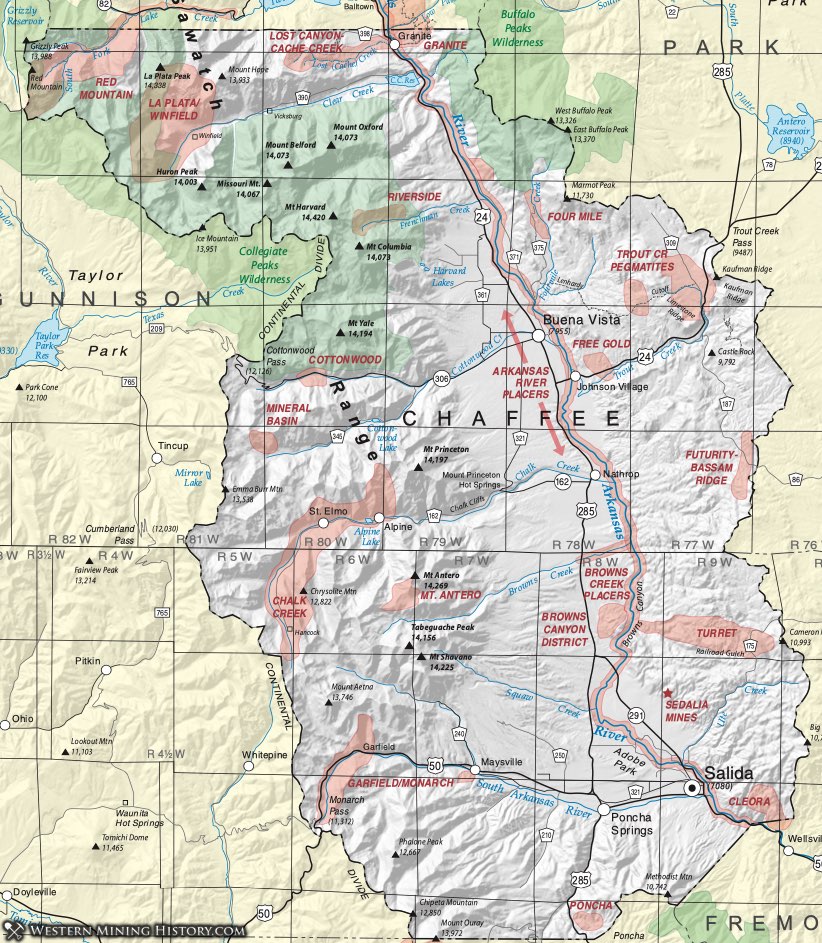
Browns Canyon District
The Browns Canyon District was one of the nation's largest producers of fluorspar from 1927 until 1949. The district covers about 9 square miles approximately 10 miles north of Poncha Springs. More than 260,000 tons of ore were mined, yielding 130,000 tons of fluorspar at an estimated value of more than $5 million (Brady, 1975). The grade of the product ranged from 85% CaF2 (metallurgical grade - 59% of shipments) to 92-97% CaF2 (ceramic grade - 39% of shipments) and 98% CaF2 (acid grade - 2% of shipments) (Van Alstine and Cox, 1969). Four mills operated in the district at the height of its production.
The fluorspar deposits occured as filling in fractures and fault breccia zones. The faults occur in country rock of granite gneiss, schist and a porphyritic rhyolite flow (Del Rio, 1960). The shear zones trend NW-SE, dipping steeply. The zone is known to exceed 3.5 miles in length. Van Alstine and Cox (1969) estimate 2 milion tons of ore and suggested that more probably exists along the unexplored trends of the fault zone.
Most of the fluorspar veins were 3 to 6 feet in width, but some reached 40 feet. Individual veins are traceable for 1000 feet or more (Cox, 1945). While there was some sulfides present, the fluorspar was accompanied mainly by chalcedonic silica. Other minerals reported include coarse quartz, opal, calcite, barite, pyrite, marcasite, clay minerals and oxides of iron and manganese.
Cache Creek Placers
The Cache Creek Placer District lies at the extreme north end of Chaffee County, adjacent to Lake County. The district is considered by Parker (1974) to extend from the Arkansas River at the town of Granite upstream to Lost Mountain. Vanderwilt (1947) included the district in the Granite District. This was the largest single placer in Colorado, and produced for nearly 60 years. The district is contiguous with the Lost Canyon placers on the upstream end.
According to Parker (1974) and Voynick (1992) gold was first discovered in Cache Creek in 1859. The Rocky Mountain News reported the placers there were producing a half ounce of gold per day per man. Early on, water was supplied by a 16-mile ditch from Lake Creek. Fairly quickly, larger companies consolidated claims and began large-scale mining. In fact, the state's only profitable large hydraulic mine operated on the terraces above Cache Creek. Finally, a lawsuit by the city of Pueblo and other downstream water users curtailed hydraulic mining (and its attendant siltation) in 1910 (Parker, 1974; Voynick, 1992).
Davis and Strufert (2011) show the placer as consisting of both fluvial and glaciofluvial elements (river gravels and older gravels deposited by and after glacial activity). Parker (1974) points out that the gravels contain very little clay or boulders and were thus very favorable for placering. The district was a prolific producer of gold and Parker (1992) points out that most of Chaffee County's gold production came from this district - more than $1million at a gold price of $20.57 (so more than 48,000 ounces.) He points out that the source of the gold was probably mostly from Lost Canyon Creek to the west and southwest and the glacial moraines of Lake Creek. Much of those source areas remain unmined.
Chalk Creek District
The Chalk Creek District lies at the upper end of the Chalk Creek drainage above Mount Princeton Hot Springs. Dings and Robinson (1957) divide the district into three areas - the Browns Creek the the east, Baldwin Gulch, 3 miles southeast of St Elmo, and a 1/2 to 2-mile wide, 10-mile long belt in the northeast corner of the Garfield Quadrangle over Chrisolite Mountain. An excellent summary of the history of the Chalk Creek District is provided in Neubert and Wood (2001) A synopsis of that history will be given here. The first discoveries in the district were made in 1873. Inaccessibility plagued the district - the distance and difficult terrain made transport of ore to a smelter an expensive proposition. Once a smelter was built in 1880, the mines increased output and local towns grew prospered. Later, a new smelter in Buena Vista gave the district mines another boost. The removal of the railroad in 1926 closed many of the mines, although production continued through sporadically till 1954 (Colorado Bureau of Mines, 1954). Neubert and Wood (2001) document attempts to reopen some of the mines as late as the 1960s.
The towns of Alpine, Romley, Hancock and St Elmo grew up in the district. Alpine was incorporated in 1879 and soon boasted two hotels, three banks, a dance hall, 23 saloons and a population of 500 (Aldrich, 1992). Romley grew up around the Mary Murphy Mine, the districts largest. Hancock was founded on the site of a placer mine and grew as a construction camp for workers on the nearby Alpine Tunnel. But by 1904, the post office closed, the last train passed through the tunnel in 1910 and the last passenger train up the canyon ran in 1926 (Aldrich, 1992). St. Elmo is the one town remaining in any form. Incorporated as Forest City in 1880, the the 1890s, the town had a population between 1000 and 1500. The post office remained until 1952 and there are still a few permanent residents along with seasonal residents and some businesses.
Ore in the Chalk Creek District occurred in pyritic quartz veins mostly in the Mount Princeton quartz monzonite. The veins varied greatly in size from inch-wide stringers 50 feet long to some 50-foot thick veins that persist for more than a mile. The mines were considered to be mainly silver mines. The only mention as to the source of the gold is free gold in the oxidized zone (Dings and Robinson, 1957). Silver occurred mainly in argentiferous galena, but Neubert and Wood (2001) cite newspaper articles from the day that mention argentite, pyrargite, proustite and tetrahedrite, particularly in the Little Bonanza vein.
Vanderwilt (1947) records production in the years 1932 to 1944 (well past the years of prime production) of 5323 ounces of gold, 45,280 ounces silver, 57,735 pounds of copper, 708,950 pounds of lead and 277,700 pounds of zinc. Most of this district's production came from the Mary Murphy (Dings &Robinson, 1975).
Cleora District
The Cleora District is a small district along the Arkansas River, 1-3 miles southeast of Salida. Named for the original railroad stop at the town of Cleora, the name remained after the main station was moved to Salida and the town disappeared (Aldrich, 1992).
While Cleora is a small district not much more than five square miles in area, its geology has drawn attention to a degree disproportionate to its size and production. The geologic interpretation of the Cleora District has evolved through the years. Belser (1956) simply discussed veins in "crushed quartz and schist." Tweto (1960) identified the host rocks as metasedimentary and metaigneous but made no assertion about the paragenesis of the mineralization. He noted possible association with nearby quartz monzonite intrusives.
Boardman in 1971 found the evidence ambiguous on the origin of the deposits but seems to lean toward the injection of veins carrying late sulfides. He did point out in Sheridan and Raymond (1977) first put forth the hypothesis that the deposits are Cleora (and other similar Precambrian deposits) are of exhalative origin. Heinrich (1981) didn't discuss origin specifically but described the Cleora deposits as consisting of fracture-controlled quartz veins in micaceous gneisses and amphibolites.
Sheridan and Raymond (1984) went into more detail on the Cleora and other similar Precambrian deposits (including the nearby Sedalia and Cotopaxi Mines) as metamorphosed seafloor exhalites, has studied extensively in Australia. Wallace et all (1997) mapped the host units at Cleora broadly as metagabbro.
Vanderwilt (1947) described the mineralization at Cleora succinctly as chalcopyrite in schist. Heinrich noted veins up to 3 feet wide and 200 feet long in gneisses and amphibolites.. Tweto's described scheelite at Cleora as disseminated in "dark schists and amphibolites," accompanied by copper. Belser (1956) was more specific, noting occurrences at each mine he visited. Sheridan and Raymond (1977) reported distinctive volcanic textures including flattened pumice fragments and clasts of porphyritic basalt in breccias. Clearly, reading the range of descriptions shows the great variety - and ambiguity - of rocks present in this suite of small mines.
Very little ore was produced in the district. Visits of Cleora show that none of the mines is large and most are, in fact, quite small. Belser's (1956) detailed descriptions document production at only the Stockton Mine (2 tons of ore ... unfortunately the Stockton Mine is now the site of a residence) and the Grand View Mine, which was worked for copper from 1890 to 1905.
The mines and prospects in the district are the Stockton, Cleora #2, Mute, Grand View, Hub Tunnel, Uncle Andy Prospects, North Star, Saddle, and Tiger Lode.
Cottonwood Creek District
The Cottonwood Creek District in west-central Chafee County is a small district that produced a small amount of gold in the past. Very little information is available about mines or deposits of the district. Henderson (1926) lists the "Cottonwood Creek" district as a placer gold district. Vanderwilt (1947) briefly noted the district was characterized by small veins of lead, silver and gold in Precambrian granite and schist. He had no recorded production. Heyl (1964) includes the "mines and prospects" of the Cottonwood Creek district on plate 1 in his discussion of oxidized zinc deposits. He quotes a personal communication with C.S. Robinson that oxidized lead and zinc ore are present on some dumps in the old district.
Heyl describes the district as characterized by schists intruded by Mount Princeton quartz monzonite. Structurally within the district lies a small syncline containing Paleozoic limestones and dolomites with bedded replacement deposits of silver-lead-zinc. He feels this area is worthy of further investigation since it shows favorable environment for bedded deposits by has never been explored in detail.
Fourmile District
The Fourmile District is a little known district in the area of Fourmile Creek, northeast of Buena Vista. Henderson (1926) lists the Fourmile in his table of Colorado mining districts. Vanderwilt (1947) places the district in T13S, R78W. but states its exact location is "unknown." The map of Wood (1983) implies the district extends into Park County, overlapping with the Buffalo Peaks District, but shows a concentration of mines and claims in sections 5, 6, 7, 8, 16, 17, and 18 of T13S, R78W. Those seven sections - all in Chaffee County - are what is used on our map.
Wood (1983) and Hedlund, et al (1983) describe gold-bearing quartz veins following northwest-trending faults in Precambrian granite along Fourmile Creek. They describe low to moderate potential for silver and gold in these veins for future development.
Production figures for 1935, 1936 and 1937 show that 78 tons of ore yielded 53.5 ounces of gold. In 1940, Vanderwilt reports that 67 tons of ore supplied 39 oz of gold, 336 oz of silver, 1000 pounds of copper, 1200 pounds of lead and 30,000 pounds of zinc.
Free Gold District
The Free Gold District lies just east of the Arkansas River. Based on reports by Keller, et al (2004) deposits typical of the district extend from Hop Gulch and McGee Gulch (sec. 3, T 14S, R. 78W and sec 6, T. 14S, R77W respectively), around the present-day Collegiate Peaks scenic overlook, to several small mines near Trout Creek, south of Highway 285. The terrain there is Proterozoic Granodiorite of the Mosquito Range. On-site investigation shows that the target of mining activity appears to have been small veins, possibly pegmatitic judging by the material in the mine dumps. The size of the dumps indicates the excavations were not deep - perhaps 30 to 40 feet - probably the extent of the oxidized zone. Discussions with personnel involved in mine closures and clean-ups with the Abandoned Mines Group of the Colorado Division of Minerals and Geology indicate that only one mine - the Nellie Bly Mine - showed evidence of some copper mineralization.
Futurity - Bassam Ridge District
The Futurity - Bassam Ridge District is an informal name applied for this publication by the authors. Several mines were investigated at the site of Futurity. These consist of small veins in black to gray calcareous and carbonaceous siltstone and fine sandstone, interpreted as a black shale environment near the contact of the Belden and Minturn Formations by Wallace and Lawson (1998). Their analyses show anomalous gold, copper and silver.
Additional prospects occur to the north along Bassam Ridge, mapped by Wallace and Keller as Leadville Limestone and Kerber Formation. The prospects appear to concentrate in an intraformational breccia. Nearby are some piles of dump material of black shale at the location appopriately known as Black Dumps, on the Park-Chaffee County line.
Garfield-Monarch District
Placer gold was discovered in the streams of the Monarch district in the 1860s, but major activity did not follow for many years. In 1878 the Boone brothers staked the Great Monarch claim. That opened the flood gates to thousands of hopeful prospectors. Very quickly claims were staked including the Fairplay, the Silent Friend, Pay Master, Ben Bolt, Eclipse and Madonna Mines (Crawford, 1913).
The towns of Garfield, Maysville and Monarch were soon founded and grew rapidly, aided by the arrival of the railroad in 1883 (Aldrich, 1992). Monarch grew around the claim of Nicholas Creede, becoming the most important of the towns, with more than twenty mines within a half mile of the town. The Madonna Mine was soon producing 30 carloads of ore a day. Ultimately the silver crash of 1893 killed the towns and much of the mining activity.
The geology of the district is characterized by Precambrian schists and gneisses overlain by Paleozoic sedimentary rocks that include rocks up to the Cretaceous Mancos Shale. These sedimentary units dip steeply. Three significant NW- trending faults cut the rocks - the Madonna, the Lake and the Mayflower faults (Crawford, 1913). Later Tertiary intrusives are found throughout the area, including a gneissic quartz monzonite, two other quartz monzonites - the Mount Pomeroy and the Mount Princeton, along with dikes of monzanite, latite, rhyolite and lamprophyre (Dings and Robinson, 1957).
Ore deposits of the Garfield-Monarch District include replacement deposits, veins, and apparently unrelated metamorphosed Precambrian deposits. The replacement deposits are the most important. They occur as both bedded replacements and along faults. The Paleozoic carbonates are the most commonly replaced units. Bedded replacement deposits are found in all the carbonate units in the District but the Manitou Dolomite is the most important, especially in contact with the Precambrian basement.
The principal type of vein deposits is pyritic quartz. The pyrite is commonly auriferous.
Oxidation of the deposits is common. Typical oxidized ore consists of soft, porous limonite containing cerussite, hemimorphite, smithsomite and some galena (Dings and Robinson, 1957). Not much zinc was produced because the district had no zinc smelter.
Of the district mines, the Madonna was the largest producer (Henderson, 1926; Vanderwilt, 1947). The mine lies on Monarch Ridge, the richest area of the district. According to the description of Deings and Robinson (1957), the Madonna ore occurs mainly in the dolomitic limestones of the Manitou and Fremont Formations, especially near the underlying Precambrian granite. The ore consisted of cerussite, native gold, smithsonite, hemimorphite, cerargyrite, argentite, some silver-bearing galena and malachite in a gangue of limonite with some dolomite, limestone and quartz. Significant production came from bodies of lead carbonate, commonly surrounded by lower-grade zinc carbonate (Hazen, 1956).
Mines south of Maysville are not contiguous with the rest of the district and are distinct geologically and mineralogically (Sheridan and Raymond, 1984). In this outlier, the mines are metamorphosed seafloor exhalites, characterized by the zinc spinel gahnite. In this way, the Maysville "sub-district" is akin to the Sedalia Mine and the mines of the Turret District to the east. The Bon Ton and Cinderella No. 7 mines are in this area.
Also, another area deserves special mention as differing from the main part of the Garfield-Monarch District. In the Huffman Park area, the Nest Egg and Royal Purple "occurrences" are characterized by abundant molybdenite with only a small amount of pyrite as the accompanying sulfide. These molybdenum-rich prospects occur within the Mount Princeton Quartz Monzonite (Worcester, 1919).
The Garfield-Monarch District has continued to sustain interest. Shannon and McCalpin (2006) noted abundant evidence of recent exploration activities in the Maysville area. Del Rio (1960) delineated several areas of potential for future exploration. He suggested the region where the Lake, Mayflower and Madonna faults converge, the areas high in the Creek Creek Valley and in Taylor Gulch - all areas covered with significant glacial till. There has been no serious exploration in these areas to the knowledge of personnel at the Colorado Geological Survey.
La Plata - Winfield District
The La Plata or Winfield District derives its name from La Plata Peak on the north edge of the district. It is also referred to as the Winfield District for the ghost town of Winfield, once the main supply town of the area. The latter name avoids confusion with the La Plata District of Southwest Colorado. The district also abuts (or overlaps) several other named districts - the Red Mountain to the North and West, the Twin Lakes to the North and East, and mines that may be associated with Mount Harvard or the Riverside District to the South.
The District has seen mining and exploration since 1867. The location of several lodes led to the establishment of the towns of Winfield and Vicksburg in 1880. These towns grew rapidly as new mines opened. Winfield reached a population of 1500 by 1890 and Vicksburg boasted its own smelter. The Silver Crash of 1893 nearly closed the towns. The opening of the Tasmania Mine in 1900 rejuvenated Winfield, but the last ore shipped toward the end of World War I and the area gradually cleared of people (Aldrich, 1992).
Ranta (1974) defined the district as the drainage basin of Clear Creek. He identified the most important unit as the Twin Lakes Pluton, first defined by Howell (1919). Fridrich et al (1998) show the area underlain by three intrusive units. In addition to the Tertiary Twin Lakes Granodiorite (which contains most of the mineralization), Precambrian intrusive rocks also underlie much of the district - the Kroenke Granodiorite and the Denny Creek Granodiorite.
Historic production was small, consisting of lead-silver-zinc veins. Mineralization at the Banker Mine consisted of silver- bearing galena, sphalerite, pyrite, molybdenite, bismuthenite in quartz veins. Molybdenum mineralization has long been recognized. Worcester (1919) discussed mines of the Winfield District in his paper on molybdenum in Colorado. In the 1960s and 1970s, molybdenum, beryllium, bismuth attracted attention. According to Ranta (1974), several mining companies drilled targets in the area. Ranta concluded that the Middle Mountain area is a deeply-eroded weak Climax- type molybdenum deposit and the Winfield Peak area represents an attractive exploration target for a molybdenum ore body.
Mount Antero District
The Mount Antero District is high and rugged with difficult access on the slopes of Mount Antero , roughly ten miles southwest of Buena Vista and ten miles northwest of Poncha Springs. While no commercial production has been done by mining companies, the area has long produced mineral specimens prized by collectors, including the Colorado State gemstone - aquamarine, the clear, sky-blue form of the mineral beryl.
Switzer (1939), Adams (1953), Dings and Robinson (1957), Del Rio (1960) and Sharp (1976) have described the geology and mineralogy of the Mount Antero deposits. The minerals occur in pegmatites within the Mount Antero Granite, the youngest of the igneous bodies on Mount Antero. The specimen minerals occur in pegmatites and mirialitic cavities that cut mainly the Mount Antero Granite itself. The granite is a very light to white granite of mainly quartz and feldspar with very minor biotite and accessories of apatite, zircon, sphene and sparse beryl. The pegmatites have a very thin gradational contact and are zones. The pegmatites are zoned, with cores of smoky quartz, microcline perthite, muscovite, albite , and fluorite with beryl, phenacite and bertrandite. Dings and Robinson (1957) associate the miaralitic cavities with beryl, phenacite fluorite and topaz. They report other minerals recognized as calcite, garnet, rutile, ilmenorutile, columbite and cyrtolite (zircon). Sharp (1976) noted the additional minerals pyrite, spessartine (whereas Dings and Robinson did not specify the species of garnet), and monazite. He discussed greisenized veins at the California Mine as containing quartz, muscovite, beryl, molybdenite with accessories bismuthinite, tourmaline, ferberite, brannerite and pyrite. He describes massive jarosite filling some cavities and ferrimolybdite as another secondary mineral.
Voynick (1994) relates some excellent stories about mineral collecting on Mount Antero.
Red Mountain District
The Red Mountain District was of minor significance in the history of Colorado mining and in production. Henderson (1926) shows the locations of some unnamed lode mines in the Red Mountain District, although he may have included them in the Twin Lakes District. Later, Vanderwilt (1947) combines the Red Mountain and Twin Lakes Districts. Writing of that combined district, he notes small gold veins in altered rhyolite and diorite and in Precambrian schist. Only a few tons of ore yielding one ounce of gold and 1 1/2 ounces of silver per ton.
The District as outlined here extends from Twin Lakes in Lake County, along Lake Creek to (and across) the continental divide. It includes Sayres, Peekaboo and McNasser Gulches, Red Mountain (including East Red, West Red, and Middle Mountain of Cruson, 1972). Most of the district lies within the Grizzly Creek Caldera which in turn is included within the Collegiate Peaks Wilderness Area.
The first mining in the area was probably in the 1860s. The Enterprise Mine produced in the 1920s and 1930s, the Eureka Mines as recently as the 1940s (Cruson, 1973). The Colorado Bureau of Mines (1969) reports summer season production at the Stewart Mine as recently as 1969 (CBOM, 1969). Cruson (1973) reported that exploration studies were conducted in the 1960s by AMAX, Union Carbide, Union Pacific and Bear Creek Mining Company. Bastin (1987) includes a table of known mines and activity and notes that Amoco Minerals conducted exploration (including drilling) for gold in the Peekaboo Gulch and Middle Mountain areas.
The geology of the Red Mountain District consists mainly of rocks of the aforementioned Grizzly Peak Caldera complex, including ash flow tuffs of andesite to rhyolite composition, latite tuff and breccias of several types. Fridrich and Mahood (1984) recognized a resurgent dome in the complex.
Mineralization occurs in a variety of environments (from Cruson, 1973, and Bastin, 1987). Veins are common, with sphalerite, chalcopyrite, galena (with exsolved altaite). Stockworks are reported at both East Red Mountain and West Red Mountain. Mineralized breccias are also found in the district. Details of each type and locations can be found in those two references.
Riverside (Mount Harvard) District
The Riverside District lies on the eastern slopes of Mount Harvard 5-6 miles east of the old town of Riverside on Highway 24. Wood (1983) and Hedlund, et al. (1983) describe the area near the river as the Riverside District.
According to Vanderwilt (1947) the district had some production from 1933 to 1939. He reports the maximum production in 1936 of 95 oz gold, 1756 oz silver, 1820 lb copper and 24000 lb lead. The only specific information available on the District concerns the Lienhart Mine. Bastin (1987) reports the Lienhart was active from 1906 to 1918 and again from 1935 to 1938. Plans were formulated to reopen the mine in the 1980s, but never culminated. Final reclamation was accomplished and the mine closed (Wood and Neubart, 2003).
The geology of the Lienhart Mine consists of veins in Tertiary intrusive rocks (Brock and Barker, 1972). The Tertiary granodiorite is intruded into the Precambrian Kroenke Granodiorite (Brock and Barker, 1972). The main adit at the Lienhart mine contained quartz, pyrite, sphalerite, galena, chalcopyrite and limonite (Wood and Neubart, 2003). The portion of the district farther east consists of quartz veins in Precambrian rock, the same as the Fourmile District. The area does display anomalous radioactivity and peridotite dikes (Hedlund, et al, 1983).
Sedalia Mine
The Sedalia Mine is not a district but a single mine. The geology at the Sedalia deposit is very much like that at the Turret District to the North and the Cleora District to the East. Because the distance between the Sedalia and these districts is significant and the Sedalia is by itself such an iconic Colorado mine, we have chosen to treat it by itself.
The deposit was discovered in 1882 (according to Lindgren, 1907) or 1881 (according to Van Alstine, 1974), and worked intermittently until 1923. The Sedalia was the largest copper mine in Colorado, producing zinc and a bit of gold and silver in addition to the copper. By 1907, 60000 to 75000 tons of ore had been shipped, with grades of 5% copper and 10% zinc (Lindgren, 1907).
Lindgren (1907) first described the deposit as a series of schits intruded by gabbro and pegmatite, the rocks metamorphosed to sillimanite grade. Boardman (1971) described the rocks similarly but added that the rocks constituted a skarn, formed by recrystallization and metasomatism of amphibolites and micaceous schists and gneisses. He described a number of rock types, dominated by a quartz-biotite rock with varying amounts of sillimanite, garnet, andalusite and cordierite. Less volumes of rocks included the assemblages actinolite-talc-chlorite; gedrite-garnet-cordierite; anthophyllite-cordierite-quartz-biotite; tremolite-thulite; hornblende-epidote-plagioclase-garnet.
Sheridan and Raymond (1978, 1984), with the benefit of evolving understanding of mineral deposits in various environments, reassessed the Sedalia Mine and similar deposits of Precambrian age. Carefully mapping the diverse geologic units in the area of the Sedalia Mine, they interpreted the geology as a sequence of submarine volcanic, volcaniclastic and sedimentary beds, intruded by magmas ranging from basalt to granitic pegmatite. The deposit itself was interpreted as an exhalative volcanogenic body, a type well known in Precambrian terrains in Canada and Australia. Strongly folded and metamorphosed to the amphibolite facies, the strataform deposit has developed a complex mineralogy (see list below).
Heyl (1963) described a thick bed of actinolite schist containing lead and zinc minerals. The primary target ore contains mainly limonite, malachite, cuprite, chalcocite with lesser sphalerite, cerussite and galena. Other zones contain up to 10% magnetite and 20% sphalerite. The zinc spinel gahnite is common. Gahnite is recognized as an indicator mineral for metamorphosed exhalative deposits elsewhere in the world. Voynick (1994) recommends the Sedalia Mine (now inaccessible) as a source for specimen minerals, particularly the large, euhedral almandine garnets weighing up to fifteen pounds.
Sheridan and Raymond (1984) estimate a million tons of remaining ore (mainly lead-zinc) with possibly more at depth.
Trout Creek District
The Trout Creek Pass District encompasses a series of pegmatites near highway 285 south of Trout Creek Pass between Park and Chaffee Counties. Vanderwilt (1947) shows production of very small amounts of gold, silver, copper and lead from 1932 to 1939 from as many as 3 mines. The district is best known as containing the most rare earth minerals in Colorado.
The pegmatites are generally small, ranging from a few meters long dimension to 85 meters. They appear to be related to small stocks of granite intruded into older granite of early Proterozoic age (Wallace and Keller, 2003). The most notable pegmatites are zoned with cores composed mainly of coarse quartz-microcline-plagioclase and thin border zones of the same assemblage plus garnet (Hanley, et al, 1950). The rare earth minerals occur within the core. These authors describe three of the most important mines - the Clora May, the Yard and the Crystal No. 8.
In a detailed study, Hanson, et al (1992) describe four of the pegmatites as classic zoned bodies - the Clora May, Yard, Crystal No. 8 and the Tie Gulch. In this mineralogical study, they describe specific LREE (light rare earth) phases allanite and monazite and HREE (heavy rare earth) phases polychrase and aeschynite.
Turret District
The Turret District, also known as the Turret Creek District, lies in southeastern Chaffee County, about ten miles north of Salida. The District is centered on Turret Gulch stretching from just west of Cameron Mountain near the Park County line, east down Railroad Gulch to the Arkansas River. The terrain is rugged and largely inaccessible, except for a few good gravel roads. The settlement of Turret sits in the middle of the district, founded in 1897 as Camp Austin (Aldrich, 1992).
Gold was the main attraction in the Turret District and production lasted until 1939. Vanderwilt (1947) reported minor production from the district of gold, silver and copper from one or two mines in the years 1932 to 1941. Albite (soda feldspar) was extracted at the Homestake Mine from 1934 until 1949, and began major production in 1953 (Bhutta, 1954). Albite production continued until 1963, along with some minor mica production (Franz, 1963).
Mineral deposits of several different types occur within the Turret District, reflecting the diversity and complexity of the geology. Gold occurs in quartz veins throughout the district (Bhutta, 1954; Wallace, et al, 1997; Wallace & Lawson, 1998). Boardman (1971) recognized that these veins occurred in the Paleozoic rocks. The Gold Bug and Golden Wonder Mines fall into that classification (Bhutta, 1954).
Pegmatites are a notable feature of the Turret District, occurring sporadically through its length. Largest was the Homestake Mine (or "Albite Mine" of Bhutta), but Hanley, et al, 1950, named also the Combination, the Last Chance, the Riegel, the Mica-Beryl and the Rock King.
Just like the Cleora, the Maysville segment of the Garfield-Monarch District, and the Sedalia Mine, the Turret District contains metamorphosed sulfide deposits in Precambrian rocks. Bhutta recognized the Independence Mine as occurring in the local augen gneiss and the Copper King in a gneiss. Heinrich (1981) described the Independence Mine, the Ace High - Jackpot Prospect in Railroad Gulch, and the Copper King mines in his review of skarn deposits in Colorado. As in those other named locations in Colorado of similar deposits, these display a complex mineralogy. Assemblages of -biotite- quartz-actinolite and cordierite with chalcopyrite, pyrite, molybdenite, gahnite and magnetite are described at the Independence. The Ace High - Jackpot contains amphibolite and a skarn of actinolite, anthophyllite, apatite, biotite, calcite, chlorite, cummingtonite, gahnite, phlogopite, quartz, phene, talc, tremolite, zoisite, magnetite and chalcopyrite. Supergene alteration of the copper-rich amphibolite contains malachite, chalcocite, azurite, chrysocolla, brochantite, chalcanthite, calcite, barite, opal and psilomelane.
Boardman (1971) recognized the possibility that the protoliths of the Precambrian deposits were volcanic-sedimentary rocks. Sheridan and Raymond (1984) finally hypothesized the connection that these Precambrian deposits are actually metamorphosed seafloor exhalative deposits, which were being studied intensively in Canada and Australia at about that time.
Del Rio (1960) describes in addition to these types of deposits, a graphite deposit two miles north of Turret, a vermiculite deposit, and marble northeast of Turret. The Calumet Iron Mine has been considered to occur within the Turret District, and may well, although that mine will be treated individually. Likewise, the Sedalia Mine has been considered a part of the Turret District. While it does occur in Precambrian rocks like those in the Turret District, so do the mines of the Cleora District. Rather than combine them all because of similar geology, this description maintains the geographic distinction and will treat them all separately.