Antelope Creek District
The only information available on the Antelope Creek District comes from Cox (1945) who lists the district as a producer of fluorspar.
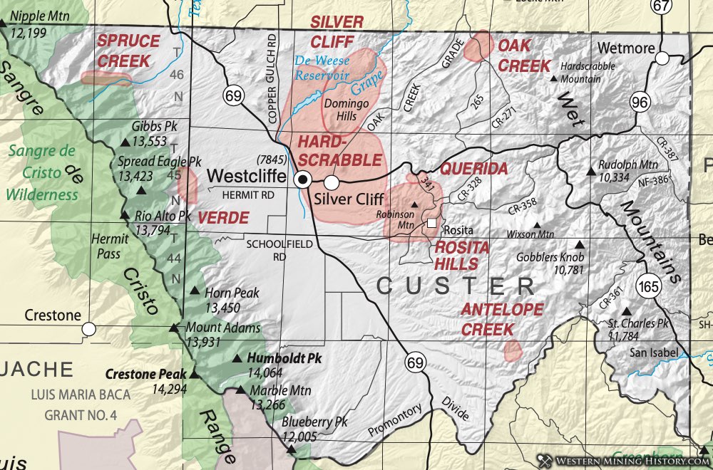
Hardscrabble, Silver Cliff, Querida, Rosita Hills Districts
Mining around the towns of Westcliffe and Silver Cliff occurred in mining districts variously called the Hardscrabble, the Silver Cliff or the Westcliffe Districts. Nearby - less than three miles to the southeast - mines were developed in the Rosita Hills or Querida District around the town of Rosita.
Deposits in both these areas occur in the same general geologic environment, originating from volcanic activity during the Oligocene Epoch, 32 to 26 million years before present (Steven, 1975). Mineralizing fluids were generated in a volcanic center - possibly beneath a single modest-sized volcano - during that time. Lava flows and tuffs were erupted onto the surface while super-heated fluids originating in the magma chamber below circulated through the rocks, depositing gold, silver, lead, zinc and copper. The feature is referred to as the Silver Cliff volcanic center.
The volcanic system formed several different types of deposits. Early fluids deposited silver ores rich in manganese in vugs and open spaces in rhyolite lava flows, probably on or near the surface at the time of the deposition. Later, fluids and superheated vapors permeated the rocks to deposit silver and base metals (predominantly lead, along with zinc and copper) in faults, fissures and other cracks in the rocks. During the late stages of the volcanic activity an explosive eruption blasted through the overlying rock, creating a pipe or chimney of rubble, providing a pathway for mineral-rich fluids to deposit gold, silver and other metals in the resulting breccia chimney.
After the main period of volcanism, the upper elevations of the volcano collapsed to create a caldera. More magma pushed up from below, leaving bodies of magma to slowly solidify beneath the now-quiet volcano as plutons.
The original discovery of silver was made in 1870. That brought on a wave of exploration and numerous mines were developed in the succeeding 20 years. The largest was the Bassick Mine, developed in the brecciated chimney at the northern edge of the old caldera. From 1872 to 1923, the two districts produced an estimated $7 million worth of silver, lead, zine, copper and gold. Most of the mines were exhausted in a few years, although the Bassick and several other smaller ones continued producing, some through the Korean War years. (Feldman & Crowley, 1980).
Geologists have recognized that the center remains a promising area for further exploration. Although much silver and other metals were recovered from the area but volcanic centers of this type with caldera are some of the most prolific silver producers known. (The Creede Caldera in Mineral County is a prime example.) Of particular interest at Silver Cliff is the recognition that metallurgical recovery from extremely rich silver ores left a lot of silver behind. Hildebrand, et al (1974), refer to individual samples reported to assay at several thousand ounces of silver per ton. Emmons, on his visit to the area in 1895, commented that ore of 20 to 30 ounces per ton Ag was being discarded as "lower grade" and "un- economic" (Emmons, 1896). Hildebrand's team found that much of the silver was contained in a complex ore with manganese that the processes of the day could not effectively treat.
The richest mines in the districts were the Bassick and the Bull Domingo. As noted, the Bassick tapped a breccia chimney at the edge of the caldera. The Bull Domingo tapped a second chimney a few miles north of the main volcanic complex. Both pipes were formed the Silver Cliff volcanic activity. Neither of these mines explored the full depth of the breccia chimneys. The extremely rich ore was mine to about 1400 feet at the Bassick and to only 550 feet at the Bull Domingo.
Several U.S. mining companies developed drilling programs in the area of the Silver Cliff volcanic complex in the 1960s and 70s. We have no record of their findings. They based their program on the fact that historically, only shallow ores were mined. Many geologists feel that mineral-rich veins continue to much greater depths than were explored in earlier years. Deeper veins, continuation of the chimneys, and the potential existence of underlying plutons (former magma chambers) are viewed as potential deposits of copper and molybdenum, in addition to silver (Sunshine Mining Company files.)
The multiple ownership of land parcels in the Westcliffe-Silver Cliff-Rosita area has been recognized as a potential problem. Consolidating land positions can present a deal-breaker for exploration and mining. Nonetheless, the old districts are believed to contain lots of silver still.
Production
Estimated production of gold from 1872 to 1980 from the Westcliffe/Silver Cliff District is 100,000 ounces; from the Rosita Hills District, 25,000 ounces. Custer County as a whole has produced 4,744,339 ounces of silver, 626,825 pounds of copper, 41,916,696 pounds of lead and 1,907,627 pounds of zinc. (Figures for the 1960s are combined with other counties, so the number above is a minimum production.) Data specific to the districts is limited to a small period of time in the 20th century, but it is certain that nearly all the totals for Custer County come from the two districts.
As for number of mines operating, in the twentieth century, the Westcliffe/Silver Cliff District saw a peak of ten producing mines in 1940; the Rosita Hills District showed 4 producing mines in 1936.
Gem Mining District and the Wet Mountains Alkalic Province
(Gem, Hardscrabble, Rosita Hills, Querida, and Silver Cliff Districts)
The Gem District is a small area that lies within the extensive Wet Mountain Alkalic Province in southern Fremont and adjacent Custer Counties. For that reason, it will be included in a discussion of that larger area. As a mining district, the Gem District has never been successful. The Wet Mountain Alkalic Province, however, has attracted considerable interest in recent years, however, because of its unusual geologic characteristics and its mining potential. The rare rock types intruded in the area contain anomalously high concentrations of critical and strategic commodities including thorium, niobium and the rare earth elements (Lanthanide elements.)
The Wet Mountain Alkalic Province is composed of three spatially separated, slightly different, igneous complexes containing an abundance of alkalic igneous rocks. The McClure Mountain Complex consists of mafic and ultramafic (pyroxenite and gabbro) and syenitic intrusions in turn intruded by carbonatite, lamprophyre and syenite dikes and thorium-bearing veins. The Gem Park Complex contains similar mafic and ultramafic cumulates intruded by carbonatite, lamprophyre and nepheline-syenite pegmatites. The third - the Democrat Creek Complex - contains subordinate mafic and ultramafic rocks and quartz syenite bordered by significant breccia zones likewise intruded by syenite dikes and quartz-barite-thorite veins (Armbrustmacher, 1984). All these Cambrian-age intrusions are contained within rocks of the Precambrian Idaho Springs Formation. (Armbrustmacher, 1979, 1984). Throughout the terrain around the three main complexes are dikes of varying composition, including carbonatites.
The rare earth element resource (REE) in the Wet Mountains Province has caught the attention of geologists. The minerals baestnesite, synchisite, ancylite, monazite and thorite have been identified within the carbonatites and contain the REE (Armbrustmacher, 1979). The minerals are known to occur over a large area - a 10 x 25-mile province containing at least 37 documented claims or prospects. Haynes (1961) stated that more than 300 prospects were known in 1958 for thorium, and it is likely that REE occur in most of those.
Several investigators noted an enrichment of the heavy rare earths (HREE) within the province. Armbrustmacher (1988) pointed out that thorite veins on the Lepley Ranch specifically are HREE- enriched. Haynes (1961) commented that the deposits across the entire province are HREE-enriched. That is important because the heavy rare earths (including dysprosium, terbium and ytterbium) are much less abundant than the LREE and command a premium in the market. Enrichment of HREE came make a marginal deposit economic.
Niobium (also known as columbium) is another critical metal for which the US is 100% dependent on imports. The metal is used as an alloying agent in specialty steels, especially for the defense and aerospace industries and such specialized applications as superconducting magnets. Niobium is distributed with the REE in the Wet Mountains area, occurring in the minerals pyrochlore, leuschite, fersmite and natronicolite (Parker and Sharp, 1970).
rmbrustmacher (1988) made some resource estimates for the REE, niobium and thorium in the Wet Mountains Complex. He estimated 161,000 short tons of ThO2; 136,000 short tons of REE (including 48,850 tons of the heavy rare earths); and over 4000 short tons of Nb2O5. These estimates are based on the known thorite veins and carbonatite dikes. Parker and Sharp (1970), in one of the earliest detailed studies of the unique deposits, postulated the presence of a large buried carbonatite body in the area that served as a source of the carbonatite dikes. (This is a typical occurrence.) Their guess was that the most likely location of this buried body is beneath the area of the large Vermiculite Mine in the area of sections 33 and 34, T20S, R72W (in the Gem District), on the Fremont-Custer County line. The CGS knows of no detailed exploration for ore bodies that do not occur on the surface.
In summary, the Wet Mountains Alkalic Province is known to contain highly desired minerals. Exploration has been only cursory and it remains a promising target for the future.
Oak Creek District
The Oak Creek District lies, appropriately, along Oak Creek in northern Custer County, twelve miles northeast of Silver Cliff, on the slopes of the Wet Mountains. The mineralization was discovered in 1879 (Hunter, 1914). It has also been called the Ilse and the Spaulding District, for the nearby town known by both those names. The geology of the area is complex, with alaskite, quartz syenite, mafic syenite, charnockite, quartz-plagioclase gneiss, diabase, and other small igneous and metamorphic bodies (Brock and Singewald, 1968).
The mineralization of the District consists is the lead carbonate cerussite (PbCO3). The cerussite occurs within fault zones in the District. The most significant production was from the Terrible Mine, with lesser production from the Wild Girl and High Kicker Mines. The deposits are characterized by significant alteration in the fault zones. Iron oxides, chert and chaledony and calcite are common. Cerussite is the only ore mineral of any significance (Hunter, 1914).
Spruce Creek District
The Spruce Creek District is listed in Henderson (1926). There is no specific information on the District. The Rita Alta Mine appears on the Electric Peak Quadrangle geologic map (Lindsey, et al, 1985). The geology of the area around the mine is the Sangre de Cristo Formation of Pennsyvanian-Permian age. The Formation is a sequence of arkosic sandstones and conglomerates.
Verde District
The Verde District is located by Dunn (2003) in the northeastern part of Custer County on the eastern slopes of the Sangre de Cristo Range. There is very little information available on the District. The District lies along Verde Creek, in the southeastern edge of the Beckwith Peak quadrangle. That quadrangle has not been mapped. The adjacent quadrangle to the south, however - Horn Peak - has been mapped. The mapped area is less than 500 feet from the southernmost mapped mine disturbance of the Verde District.
Based on the Horn Peak Quadrangle, the bedrock geology of the District appears to be a thick sequence of red arkose, arkosic sandstone, and conglomerate of the Sangre de Cristo Formation.
Dunn (2003) notes that the Verde District "may" contain the Arkansas No. 1, the New York, and the Grand View Mines. The Mineral Resource Data System (MRDS) shows the Verde Strip Mine lying in that area, but in the Electric Peak Quadrangle, two sections to the west. It is listed as a past producer, containing galena, chalcopyrite, molybdenite and pyrite in epithermal veins in the Sangre de Cristo Formation. This may represent the mineralogy present in the Verde District, although that can't be confirmed.
Eckel (1997) lists annabergite, chalcopyrite, pyrite and tetrahedrite at the Verde Mine.