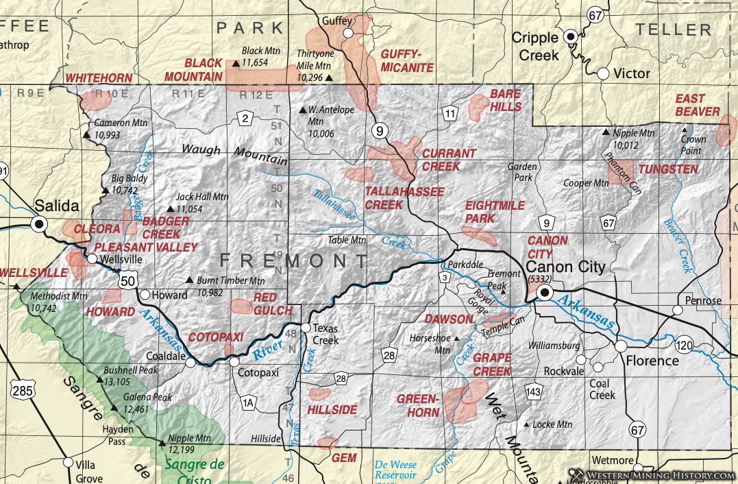
Alhambra District
The Alhambra District crosses from Fremont into Park County. Dunn (2003) indicates it is also referred to as the Freshwater District. It also overlaps with the Guffey District, although Alhambra is listed here because the name appeared in Henderson (1926). See the Guffey District (Park County) for additional data.
Arkansas River Placers
Vanderwilt (1947) notes that placer mining occurred on the Arkansas River in Fremont County from the Chaffee County line downstream to Florence. Small amounts of placer gold were produced before 1945. Diggings can still be seen in terrace deposits above the river. The physical description is the same as that for Chaffee County.
Badger Creek District
Vanderwilt (1947) notes that deposits of the district are found four miles up Badger Creek from the Arkansas River. No other references have been found.
Bare Hills District
Dunn (2003) notes that the district overlaps the South Cripple Creek District. For the map, this project has placed the district in the area called Bare Hills. The name appears in Henderson (1926).
Black Mountain (Carbonate) District
Dunn (2003) notes that the district possibly overlaps the Carbonate District. We have included them together on this map because of the lack of defining information. We have also made the district contiguous with the Black Mountain District in Park County. The name appears in Henderson (1926). No further information has been found.
Canon City District
Dunn refers to Hill (1912) and Vanderwilt (1947). The latter briefly describes the district as veins of copper and tungsten in Precambrian granite. The geologic map of the Canon City Quadrangle, however, shows no Precambrian rocks in the township noted. Harrer and Tesch (1959) describe a limonite-rich bed above the Arkansas River. Clay has been mined in the area historically. The Canon City District is described by Del Rio (1960) as "all the clay bearing-strata between Sixmile Creek on the East to Parkdale on the west." Del Rio cites the Purgatoire Formation and the Graneros Shale as sources of the clay.
Cleora District
See the Cleora District in Chaffee County.
Cotopaxi District
The Cotopaxi District surrounds the iconic Cotopaxi Mine, near the Arkansas River outside the small town of Cotopaxi. Lindgren (1908) visited the mine site and noted that the Cotopaxi, while inactive at his visit, had been "a considerable shipper of copper ore." Activity resumed off and on in the years since, the most recent documented being drilling and experimental copper leaching in the late 1960s (Blake, 1969).
Heinrich (1981) and Salotti (1965) detailed the geology and rock types present. They are listed as biotite gneiss, nodular sillimanite gneiss, amphibolite and lime-silicate rocks. The mineral assemblage is typical of Precambrian deposits that have been interpreted as metamorphosed seafloor assemblages of sediments and volcanics, including volcanic exhalative ores (Sheridan and Raymond, 1984) characterized by the zinc spinel gahnite. In the Fremont-Chaffee County area, other similar deposits are found in the Turret, Cleora, Grape Creek, Currant Creek and Guffey Districts and, most notably, at the Sedalia Mine.
The ores consist predominantly of sphalerite with subordinate chalcopyrite, although numerous ore minerals occur (see minerals list below) (Salotti, 1964).
Currant Creek District
Dunn (2003) notes that the Currant Creek District is listed in the original references - Hill (1912) and Henderson (1926). Vanderwilt lists occurrence of zinc, copper, lead, gold and silver in Precambrian granite. No production was reported (Vanderwilt (1947), although the district is listed as a "past producer" on the Minerals Resource Data System, presumably from U.S. Bureau of Mines records.
The geology of the Currant Creek District is similar to that of other nearby districts that form a group extending northwest from the Wet Mountains into Park County. The districts include the Greenhorn and Grape Creek and the Black Mountain and Guffey Districts of Fremont and southern Park County. They occur in Precambrian gneisses and schists, with some younger intrusives.
Heinrich (1981) discussed many of the recorded claims through that area. He cites the Fremont County occurrences as tungsten-bearing skarns of the Guffey - Tallahassee Creek areas. He lists the Four Claim Group and Venture No. 1 Claim and also the Isabel Mine. The deposits are lensoidal, tabular or podiform. Scheelite occurs in calc-silicate or cordierite- anthophyllite gneisses or amphibolites. Since then, these rocks have been interpreted as metamorphosed marine sequences that include mineralized volcanic exhalatives and associated shallow intrusives (e.g. Sheridan and Raymond, 1984).
Dawson District
The Dawson District lies in the lower reaches of Grape Creek, about five miles southwest of Canon City. The town of Dawson City sprung up in 1898 and lasted only several months. The discovery of a rich lode that became the Copper King Mine. That discovery precipitated a rush of claim-staking that culminated in a population of 500 people in tents and makeshift cabins in the area. It was soon recognized that the discovery was apparently minor and the rush died (Eberhart, 1959).
The Copper King contained copper, gold and silver in a stratabound deposit in metamorphic rocks. In the 1980s, considerable exploration efforts were expended in the Dawson District. The investigations defined stratiform gold-bearing zones with overlying massive sulfides. The interpretation is a metamorphosed polymetallic deposit originating as a submarine volcanic exhalative system (Sunshine Mining files, Colorado Geological Survey). The gold and sulfide zones have been traced over a strike length of several miles in a northeast-southwest direction, probably contiguous with similar zones in the Greenhorn and Grape Creek Districts to the southwest. Massive sulfide horizons are stretched and distorted, ranging in thickness from a few inches to twenty feet. Sulfides are dominantly pyrite with chalcopyrite, pyrrhotite, sphalerite and galena, occurring in a matrix of chlorite-biotite or, locally, quartz-anthophyllite.
Eight Mile Park District
The Eight Mile Park District is a classic pegmatite district covering about ten square miles adjoining the Royal Gorge west of Canon City. Mining began as early as 1900 and continued sporadically through the 1960s (Martin, 1993; Colorado Bureau of Mines annual reports.) Precambrian rocks in the area are granites, schists and gneisses. These are intruded by dikes of pegmatite, aplite and basalt. The larger pegmatites occur north of the Arkansas River. They can be as large as 1000 feet long and 650 feet wide. South of the river, the bodies are much smaller.
The pegmatites were mined mostly for feldspar and quartz, but beryl, columbite-tantalite and some other commodities were produced. Activity as recent as the 1960s saw quartz, beryl and mica at the Devils Hole Mine, quartz at the Zingheim Mine and mica at the Mica Lode (Colorado Dept of Mines annual reports). Several of the mines are specifically discussed in Baillie (1962) and Sharpes (1962).
The Mica Lode was the largest producer of feldspar in Colorado and one of the largest producers of beryl and mica. Hanley, et al (1950) describe mica blades up to ten feet long at that mine. According to their investigation, the mine produced 169,000 tons of feldspar, 34,700 tons of scrap mica, 57 tons of beryl and 615 pounds of columbite-tantalite.
The Meyers Quarry, on the other hand, contains almost no beryl, but rather pods of cleavelandite and lepidolite. It is principally a microcline-muscovite pegmatite (Hanley, 1950). Hanley, et al, also described the School Section Pegmatite as containing quartz-microcline-muscovite-biotite-black tourmaline-apatite-beryl-garnet-thorite-triplite-bismutite.
Grape Creek District
With geology very similar to the Dawson District to the northeast, the Grape Creek may be considered along with the Greenhorn District, as a continuous geologic terrain.
Mineralized layers of schist and gneiss have been subjected to numerous periods of deformation. The protolith of the rocks is probably a seafloor sequence of sediments, volcanics, volcaniclastics and exhalative deposits. Vanderwilt (1947) indicates that lead and zinc ore was produced at some point.
Guffey-Micanite District
The Guffey-Micanite Districts overlap in the area around Highway 9 in southern Park and northern Fremont Counties. In his discussion of Park County districts, Scarborough (2001) points out that the Guffey District (also known as the Freshwater District) contains lode deposits of nine different types. Tis diversity of mineralization, the nomenclature in this area and the overlapping of the historic Guffey and Micanite Districts along with the existence of several other district names (such as Fourmile in Scarborough), creates potential confusion. In this report, we attempt to simplify that. The Micanite District will be used to refer to pegmatite deposits. The Guffey will be used to refer to all the other deposits.
In the Guffey District, the deposit types that Scarborough lists are tungsten and copper-zinc skarns, vein deposits in Proterozoic crystalline rocks, stratiform deposits in metasedimentary sequences, stratabound uranium-vanadium deposits and volcanic-hosted pumice and manganese deposits.
According to Eberhart (1959), the town of Guffey has also been known as Freshwater and Idaville. It reached its peak in 1895, so it is assumed that was also the height of mining activity in the area.
The Isabel Mine is a copper-zinc skarn deposit with sphalerite, galena, chalcopyrite in a recrystallized amphibolite. The gangue includes quartz, actinolite, zoisite, garnet, and some gahnite and pyrite. This assemblage demonstrates its affinity for the metamorphosed Precambrian exhalites, as are found in the Sedalia and Cotopaxi mines and others. Described by Heinrich (1981), the Isabel could probably be considered in the Currant Creek or Grape Creek Districts. For this report, it is included in the Guffey.
The Micanite District gets its name from the old Micanite post office two miles south of the Park County line. The pegmatites have been reviewed by a number of authors. Sterrett (1923) pointed out that the pegmatites are intruded into Precambrian gneisses and schists. Characterized by pink orthoclase, white albite, the pegmatites carry large beryl and apatite crystals in some locations along with "50-pound blocks of mica." He describes a number of the deposits in detail.
Baillie (1962) describes a number of the mines, as does Sharps (1962). They determine that only small reserves of mica and feldspar remain. Heinrich and Bever (1957) also describe individual pegmatite bodies. They singled out the Baumer Pegmatite (in Park County) for its radioactive minerals euxenite, monazite and allanite, along with radio active ilmenite. (They determined that the ilmenite contains radioactive inclusions - probably euxenite and monazite.) Notable occurrences of sillimanite are listed at Meyers Ranch, the Betty Mine, Dicks Creek, the Whopper Pegmatite, with kyanite at the Dicks Creek location.
Hillside District
Very little data. Considered part of Gem/Gem Park District. Listed in Dunn (2003) and Vanderwilt (1947) as shipping gold ore in 1947.
Howard District
The Howard District is listed both under the Cotopaxi District and as Howard in Mindat.org. On the Mineral Resources Data System, the Howard prospect is listed as a pegmatite, with potential mica and feldspar resources. Other sites attributed to the Howard District list the minerals below, characteristic of metamorphosed sedimentary - volcanic sequences, such as occur at the Cotopaxi Mine.
The District is listed in Dunn (2003) and referenced in Henderson (1926).
Red Gulch District
The Red Gulch District is an occurrence of sediment-hosted copper approximately 8 to 9 miles north of the town of Cotopaxi. The area was described by Lindgren in 1908. The details below are all from Lindgren's report.
Exploration in the district began in 1907 and "several cars of ore" were shipped, most from the Copper Prince Mine. The copper occurs in sedimentary red bed deposits, in the sequence of Minturn Formation, Belden Formation, Harding Sandstone and Manitou Limestone (MRDS). The primary ore minerals are chalcocite, malachite and azurite. Ore follows a thin (4-foot) black shale and commonly occurs with thin layers of coal.
The Minerals Resource Data System reports silver and vanadium along with the copper.
Whitehorn District
The Whitehorn District lies in northwest Fremont County, adjacent to the Calumet Iron Mine in Chaffee County. There is very little information published concerning the district. Eberhart (1959) reports that the camp of Whitehorn was established in 1897 where a railroad worker found gold while cutting timber. By 1900, a town was thriving. The mines survived into the 20th century, but the Whitehorn Post office closed in 1918. Eberhart also lists the Cameron, Golden Eagle and Independence as mines in the district that supported much of the population, but no other sources were found to corroborate that. Eberhart also indicates that a railroad served the town of Calumet nearby across the county line.
Boardman (1976) points out the presence of gold and copper in the area and Vanderwilt (1947) describes the district as characterized by small deposits of gold and silver. The Mineral Resources Data System (http://tin.er.usgs.gov/mrds/find- mrds.php) lists gypsum as a resource in the district.
Discussion with personnel from the Colorado Division of Reclamation, Mining and Safety Abandoned Mines program reveal that the mines there are mostly shafts to exploit quartz veins, much like the Free Gold District in Chaffee County.