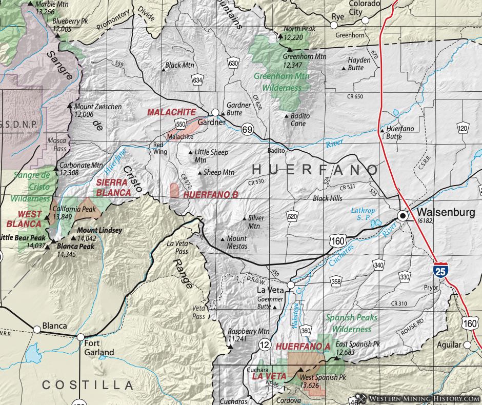
Huerfano District
Dunn (2003) lists two Huerfano Districts, designated A and B. The District she terms "Huerfano B," while shown using her coordinates on the accompanying map, is considered to be part of the Malachite District, as indicated in Vanderwilt (1947).
The "Huerfano A District" is at the southern end of the county in the vicinity of the Spanish Peaks. Vanderwilt (1947) reports 168 ounces of gold, 1176 ounces of silver, 92 pounds of copper and 1067 pounds of lead were recovered from the area.
Several old mines are found in the vicinity of the West Spanish Peak. Budding and Kluender (1983) found mineralization there in veins along a shear zone and in the contact metamorphic aureole around the Spanish Peak intrusive. They report samples from an adit of the Bulls Eye Mine of 0.026 ounces per ton of gold, 2.2 ounces per ton of silver, 2.7 per cent lead and 4.4 per cent zinc.
La Veta District
Vanderwilt (1947) reports a small amount of placer gold production from Wahatoya Creek and small tributaries to the Apishapa River. The source of the gold has not been identified. Lode deposits with silver, copper, zinc and tetrahedrite are reported. The geology consists of metasediments in contact with the intrusive rocks with some veins in the augite diorite of the intrusive rocks themselves. To the north, in the LaVeta Pass area, copper, uranium and vanadium have been reported in redbed sequences along the east flank of the Sangre de Cristo Range. In the files of the Colorado Geological Survey, Atomic Energy Commission Preliminary Reconnaissance Reports document elevated concentrations of those three commodities. Up to 3.6 per cent V2O5, 3.5 per cent copper and 0.3 to 0.36 per cent U3O8 are reported in some of the documents.
Malachite District
The Malachite District is described by Vanderwilt (1947) as lying 5 miles southwest of the town of Gardner. This is probably contiguous with the Huerfano "B" District of Dunn (2003). In the area, uranium, vanadium, and copper with some minor silver in arkosic red sandstones and associated rocks appear similar to those described in the LaVeta Pass Area in the same units - Farasita Formation and Sangre de Cristo Formation (Baskin, 1983).
Sierra Blanca and West Blanca Districts
The area referred to as the Sierra Blanca and the West Blanca Districts are also referred to simply as the Blanca District at times. These all refer to the area in Western Huerfano County (and contiguous Alamosa County) along and, in places, over the crest of the Sangre de Cristo Range, between Blanca Peak on the south and Carbonate Mountain on the north.
The area was covered in reports of studies of the potential Sangre de Cristo Wilderness Area. Johnson, et al (1984) considered the area around Carbonate Mountain, crossing the crest of the Sangre de Cristo Range, southeast of Great Sand Dunes National Park. The host rocks were interpreted to be highly deformed and metamorphosed Minturn Formation, containing gold, silver, and copper. The area was assessed to have a moderated potential for mineral development.
Several miles south of Carbonate Mountain an area spanning the boundary of Huerfano and Costilla Counties near Blanca Peak roughly corresponds to Dunn's (2003) Sierra Blanca District. There a gneissic tonalite and metadiorite contains veins with gold, silver, tungsten and copper. This area was considered by the authors as an area of high potential.
Scott (1986) looked at this area later for the U.S. Bureau of Mines. The area contains a system of several large veins called the Courthouse Vein System. He points out that 40 ounces of gold are reported to have been removed from the system, but this is probably only a fraction of the actual amount. He interpreted the area to be of high potential also, for gold, silver and tungsten with the possibility of tellurium and platinum resources. His estimates were 4 million tons with an average grade of 0.4 ounces gold, 8 ounces of silver and 0.01 per cent WO3. in these large quartz veins. His estimate at the time was a value of $500 million at prices of $300 per ounce for gold, $6 per ounce for silver and $0.04 per pound for tungsten.
In the Mineral Resources Data System (MRDS), additional commodities are listed for these districts. They are molybdenum, antimony, and tellurium.