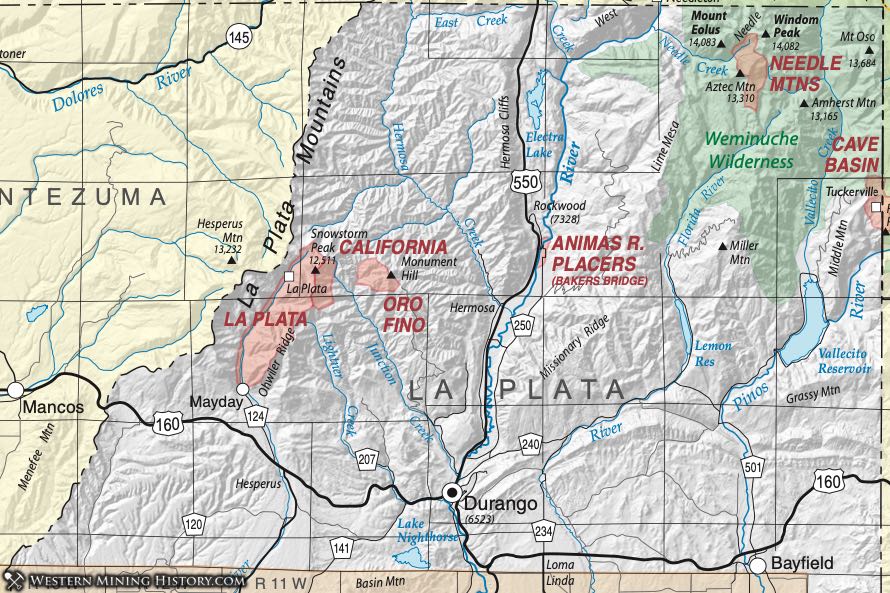
Cave Basin District
The Cave Basin District is a minor, poorly-defined and little known district at the head of Cave Basin Creek, a tributary of the Los Pinos River, near the La Plata - Hinsdale County line (Dunn, 2003). Vanderwilt (1947) states that reports place deposits on the slopes of Mount Runlett, which he could not locate; Runlett Peak does appear on maps now on that county line.
Steven et al. (1969) include a short description of the Cave Basin area. Replacement deposits in lower Paleozoic sedimentary rocks near the base of the section contain base and precious metals. They quote total production from the Holbrook, Mary Murphy and Silver Reef veins (sporadically from 1913 through 1928) of 12 ounces gold, 237 ounces silver, 2900 pounds copper and 1700 pounds lead.
La Plata District (aka California District)
The La Plata District lies in the La Plata Mountains of southwestern Colorado, northwest of the city of Durango, between the San Juan Mountains and the Colorado Plateau. Most sources recognize it is synonymous with the California District; Vanderwilt (1947) also notes the names of the Oro Fino and May Day Districts are associated with (or included in) the La Plata District. Dunn (2003) states that several "regional districts" are included, such as the McQuiety District.
The La Plata Mountains consist of a complex laccolithic terrain, 15 miles in diameter, with sedimentary rocks uplifted by numerous intrusions of dikes, sills, and stocks and subsequently eroded. The exposed sedimentary sequence ranges from the Pennsylvanian Hermosa Formation to the Cretaceous Mancos shale. All the igneous rocks are tertiary, characterized by Eckel (1947) as either porphyritic or non- porphyritic. The porphyritic rocks are nearly all monzonites and diorites, with syenites being added to the mix in the non-porphyritic portion.
Ore was first discovered in 1873, but only minor production occurred until 1900. From then until the 1930s, there was significant production, with the May Day and Idaho mines being the largest producers. Gold was the leading product, but silver and some lead and copper were also recovered.
The area is noted for its telluride minerals and for the large variety of minerals found in the deposits. Mineralization styles are predominantly veins and replacements of gold and silver-bearing telluride ores. However, a large variety of deposit types are present. Described by Eckel (1947), they are "disseminated deposits of platinum-bearing chalcopyrite; gold-bearing contact-metamorphic bodies; veins, replacements and breccia bodies of pyritic gold ore; veins of mixed base-metal sulfides with silver or native gold; chalcocite veins; and veins of ruby silver ore."
More detail of the geology and the deposits can be found in Cross et al. (1899), Eckel (1936a; 1936b), and Emmons (1905). Eberhart (1969) relates information on the mining camps of Parrot City, La Plata City, and May Day. Detailed descriptions of many of the mines are contained in Eckel (1949).
Needle Mountain District
The Needle Mountain District lies in the northeast corner of LaPlata County, in and around Chicago Basin, 6 miles east of the Needleton station stop. Vanderwilt (1947) points out that mineralization extends to the south to the headwaters of the Florida River and to the southeast to the headwaters of Vallacito Creek. Dunn (2003) notes that the district includes other smaller districts such as the Chicago District of Irving and Emmons (1905).
The Needle Mountains lie within a domal uplift of Precambrian rocks in the southwest part of the San Juan Mountains. On the south, southeast and west the dome is flanked by Paleozoic and Mesozoic sedimentary rocks, and to the north and northeast, the Tertiary volcanic rocks of the San Juans proper (Barker, 1969). Schmitt and Raymond (1977) found that mineralization in the district is associated with a highly altered upper Tertiary stock and numerous nearby quartz-sulfide fissure veins.
Veins in the Precambrian crystalline rocks contained gold, silver and copper. Pyrite, chalcopyrite and galena were commonly present in a gangue of quartz, rhodochrosite, fluorite, chalcedony with occasional barite and calcite. Detailed descriptions of much of the mineralization can be found in Steven et al. (1969).
Mining began in 1881 and lasted until roughly 1917 (Steven et al., Ibid). In early years, the only material that could be transported economically from the remote district was hand-sorted gold and silver ore. Gold was present only in local oxidized portions of the mineralized veins. In fact, vehicle access was not achieved until 1968. Vanderwilt listed production for 1934 of 80 ounces of gold with the Vallacito sub-district producing 29 ounces of gold and 4 ounces of silver in 1935-36.
Oro Fino District District
The Oro Fino District is listed by Dunn (2003), Vanderwilt (1947) and mindat.org as being part of the La Plata District. It is included with that district.
Of the identified mines within the sub-district (Dunn, 2003), the Durango Girl and Jenny Lind are listed in mindat.org in the La Plata District. The Durango Girl Mine is described in detail in Eckel (1949).