Crystal Mountain District
The Crystal Mountain District stretches across three townships in Larimer County. Mining began as early as 1884 at the Buckhorn Mine; the Crystal Silica Mine began producing prior to 1910 (Thurston, 1955). Production occurred sporadically during the period 1935 to 1945 and 1955 through 1965. Beryl production was listed last in 1965 (Colorado Bureau of Mines, 1965). The Colorado Bureau of Mines report for 1964 notes that beryl and mica were being mined at the Yo-Jo, Big Boulder, Corral Pole and Langstone properties and that the Jolex Mica Plant operated during the year (Franz, 1964).
Martin (1993) describes the main country rock as schists of the Idaho Springs Formation. The pegmatites themselves are related to Silver Plume granites. Most of the pegmatites are unzoned feldspar (perthite) and quartz-rich with a good bit of black tourmaline. A few zone bodies are particularly rich in beryl.
Baillie (1962) describes specifically the Double Opening, Big Boulder and Hyatt Beryl Mines. Sharps (1962) assesses possible remaining mica reserves at the Buckhorn, Hyatt Beryl and Langston Pit. The Bureau of Mines surveyed specifically the Crystal Silica, Buckhorn, Tourmaline Prospect, Bull Elk Prospect and Beryl No. 5, along with an unidentified quarry (Langston Pit?) (Martin, 1993).
Drake District
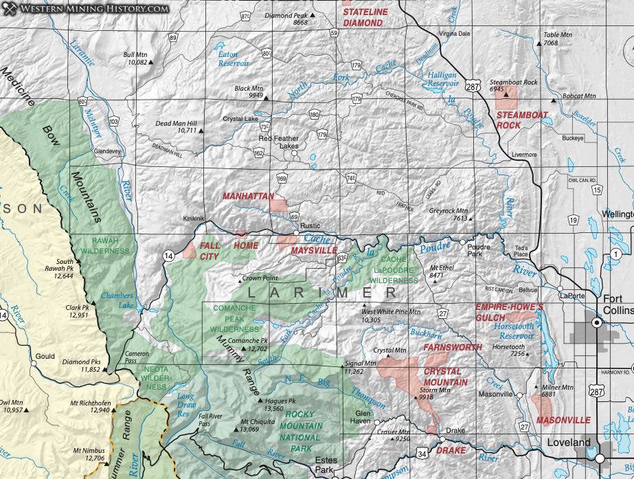
Dunn (2003) describes the Drake District based on accounts in Vanderwilt (1947).
Vanderwilt states that the district, lying at an altitude of 7000 to 7500 feet, contains copper and gold ore. No production is reported and no other data are available.
According to the geologic map (Braddock, et al, 1970), the rocks in the area of the Drake District consist of metasedimentary rocks with Precambrian tonalite intrusives and abundant pegmatites.
Empire District
The Empire District is also known as the Howe’s Gulch District. The district lies near the Horsetooth Reservoir southwest of the town of Bellevue. According to the Mineral Resource Data System (MRDS), activity in the district started in about 1873 and was sporadic. Very little ore was produced. Claims were patented in the time period from 1889 to 1900, the main one being the Empire Claim.
Vanderwilt attributes the mineralization to poorly-defined veins with cupriferous pyrite, along with chalcopyrite and some gold in Precambrian granitic schist. The geologic map of the area (Braddock, 1989) shows various metasedimentary and metavolcanic rocks in the sequence.
Home District
Dunn (2003) lists the Home District based on its reference in Vanderwilt (1947). Vanderwilt places the district along State Route 14 on the Poudre River west of Rustic. Lovering and Goddard report mineralization occurs in small veins with gold and copper in Precambrian granite gneiss near a Silver Plume granitic intrusion. They describe intense wallrock alteration around veins containing pyritic copper. There has been no apparent commercial development.
Manhattan District
The Manhattan District lies on the Cache la Poudre River at about 8500 feet elevation. Vanderwilt (1947) documents minor production from 1932 through 1941, totaling 16 tons of ore with 27 ounces of gold and 9 ounces of silver.
The mineralization occurs in nearly vertical veins - the Gold King, the Emma, the Prodigal, Monte Cristo and Colorado veins. The Gold King vein crosses a hornblende porphyry stock and granite; the Emma and Prodigal veins occure in the granite; the Colorado and Monte Cristo follow a dike of monzonite porphyry. The unoxidized ore is coarse white quartz with disseminated pyrite and chalcopyrite assaying at 0.25 to 0.35 ounces per ton. The oxidized ore is reported to have assayed up to 15 ounces per ton.
Masonville District
The Masonville District lies west of the town of Masonville in Larimer County (Dunn, 2003). According to Vanderwilt (1947) the district produced some gold and silver ore from 1935 to 1943, totaling 93 ounces of gold and 83 ounces of silver.
The district apparently lies in Precambrian rocks bounded by faults adjacent to Paleozoic sediments (Braddock, et al, 1970).
Maysville District
The Maysville District is a small area in the Cache la Poudre canyon. There is no documented commercial production, but the Crown Point vein was reportedly worked in the 1880s (Lovering & Goddard, 1950).
Gold ore occurs in veins in hornblende gneiss. The oxidized ore assayed at 0.9 ounces per ton and the unoxidized or less than half that (Lovering & Goddard, 1950).
Steamboat Rock District (Gray's Rock)
The Steamboat Rock District is listed by Hill (1912) as containing copper and gold northwest of Fort Collins. Vanderwilt (1947) repeats the citation and notes copper and gold in small veins in Precambrian rock. Vanderwilt says that the district is "probably in the same general area as the Home District." For this publication, we've chosen to place the district in the area of Steamboat Rock, north of Fort Collins. Geologic maps of the area (Braddock, et al, 1988; Braddock et al, 1989) show the presence of Precambrian crystalline rocks in the area, although no evidence of mining appears on maps.