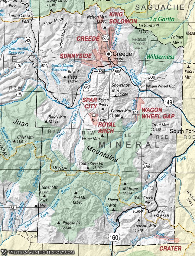
Creede District (aka Sunnyside District; King Solomon District)
The Creede District is named for the dominant town in the area, which was named for an early mine owner, N.C. Creede. He was a prospector and co-owner of the Holy Moses and Amethyst claims. Hill (1912) referred to the area as the Sunnyside District, as did Henderson (1926), who also used the term King Solomon District. The district’s dimensions are about 4.5 miles wide by 5.75 miles long.
Miners and prospectors traversing the region made the first discovery in 1882, starting with the Bachelor claim (Henderson, 1926). More discoveries followed and a rush ensued. Nearby camps of Weaver, Willow and Sunnyside grew up during the boom (Eberhart, 1969).
This district produced silver, lead, gold, and zinc and was one of Mineral County’s most important mining districts. The district was also one of the most productive in the United States (Dunn, 2003), producing nearly 5 million ounces of silver in 1892 alone. In total, Barton et al. (2000) reported a production of 2,400 metric tons of silver (79 million ounces) along with 4.7 metric tons (0.15 million ounces) of gold, 139,000 metric tons (305 million lbs) of lead, 2500 metric tons (5.5 million lbs) of copper, and 40,000 metric tons (90.3 million lbs.) of zinc.
The Creede district occurs within the Creede caldera of the San Juan Mountains volcanic complex. The Creede District and the general area of the western San Juans has been studied extensively. In fact the area was the subject of fourteen papers in a classic volume edited by Bethke and Hay in 2000. The volcanism is Oligocene in age, beginning with an andesitic base, followed by voluminous eruptions of silicic tuffs (Lipman, et al, 1978; Lipman, 1980; Steven and Lipman, 1976).
The Creede volcano erupted late in the history of the region and the caldera was formed by collapse after eruption of the Snowshoe Mountain tuff (Steven and Lipman, Ibid) at about 26.5 ma. The collapse was followed by the formation of a caldera lake and a complex sequence of sediment deposition, hydrothermal circulation, dome resurgence, complex mixing of waters that form the basis of the aforementioned GSA special paper (Bethke and Hay, Ibid.) The sequence of events developed a complex mineralogy (listed below) that is truly incredible (Rosemyer, 2010).
In general, the mineralization can be described as silver-lead veins in faults, fissures and fractured zones in rhyolite. Sphalerite, argentiferous galena, gold, pyrite and chalcopyrite occur in a gangue of quartz (often, and famously, amethyst), chlorite, barite and fluorite. Secondary enrichment contributed to the complex mimeralogy.
Spar City District (aka Royal Arch District)
The Spar City District is a small district on the southern edge of the Creede Caldera (Steven and Lipman, 1973). It is described by Steven (1964) as a small mineralized area along the south flank of the caldera, prospected sporadically since the early 1900's. Remnants of galena, sphalerite, barite, manganese oxides and jaspery to amethystine quartz occur in old dump. Commodities included Silver, Lead, and Zinc.
Wagon Wheel Gap District
The Wagon Wheel Gap District is a small district near Creede that comprised one of the four major fluorspar districts of Colorado (Dunn, 2003). Aurand (1920) described the deposits as a vein within Tertiary rhyolite tuff. The one mine was the American Fluorspar Company Mine. Descriptions of the minerals can be found on mindat.org, in Lunt (1915), Larsen and Wells (1916), and Korzeb (1992).
Production began in 1911 and the American Fluorspar Company Mine was worked intermittently until 1950 (Dunn, Ibis). The mill remains adjacent to the hot springs resort.