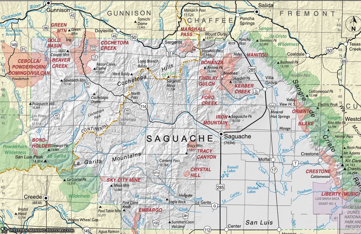
Beaver Creek District (with Gunnison County)
The Beaver Creek District is a small, poorly-defined district in northwestern Saguache County. It was mentioned by Henderson (1926) as synonymous with the Midland District. The website mindat.org does not list either district in Saguache County, but lists mines named Beaver Creek in the White Earth/Powderhorn District. Mindat.org does list the Midland Mine, in the Spring Hill Creek quadrangle (Olson et al., 1975), as part of the Domingo District (Vulcan District) in Saguache County and as part of the Goose Creek District in Gunnison County.
In Sheridan et al. (1981) the Midland Mine is described as a high-gold, low base metal mine in metachert within an amphibolite schist. This is typical of rocks of the Gunnison Gold Belt (Gunnison District.) Refer to the Gunnison District in Gunnison County, for more detailed information.
Blake District (aka Mirage District, aka Cotton Creek District)
The Blake District is described by Dunn (2003) as lying at the head of Cotton Creek, 10 miles northeast of Mirage and the area of Mirage Creek. The district is listed by Henderson (1926) and by Vanderwilt (1947), and the latter lists the district with synonyms Mirage and Cotton Creek.
Cappa and Wallace (2007) discusses the Blake District along with the Steel Canyon and Hayden Pass Districts as all being similar. The Steel Canyon and Hayden Pass areas lie north along the west slope of the Sangre de Cristo Range on the opposite (north) side of the Orient Mine iron ore district (Orient District) from the Blake. These districts appear to be very similar, as part of a belt of Precambrian rocks.
According to Ellis and others (1983), production from these districts was 5 oz. of gold, 7,000 oz. of silver, 70,000 pounds of lead, and 8,000 pounds of copper. Mineralized structures in the Copper King and Victor mines in Steel Canyon consist of veins in fractured carbonate rock (possibly the Leadville Limestone). The veins pinch and swell to 3 feet in thickness; they consist of silver-bearing galena and minor chalcopyrite in a gangue of quartz, calcite, and minor fluorite and barite (Lindsey et al., 1985). Samples taken from the Copper King Mine during a wilderness assessment assayed from 0.006 to 0.043 oz. per ton gold and 0.3 to 34.2 oz. per ton silver and contained anomalous amounts of copper and lead (Lindsey et al., Ibid). Samples taken from the Victor Mine during the same wilderness assessment assayed from 0.3 to 10.3 oz. per ton silver and contained anomalous amounts of copper and lead (Lindsey et al., Ibid).
The listing of the district on mindat.org is interesting in the wide variety of minerals and range of mineralization it includes. Of the list of mines, claims and prospects below, eight contain base and/or precious metals, two contain manganese, three contain uranium and/or vanadium, one contains fluorspar, and one some rare earth element bearing minerals.
Clearly the district was never a big producer and is not well understood.
Bonanza District (aka Kerber Creek District)
Dunn (2003) follows the example of Henderson (1926) in identifying the Bonanza District with the Kerber Creek District. She describes it as occupying 17-18 square miles, overlapping with the Clover Creek and Silver Creek Districts (which we do not discuss). Vanderwilt's (1947) preferred name is the Kerber Creek District, occupying the area surrounding Kerber Creek in the Cochetopa Hills at the northwest end of the San Luis Valley.
Burbank (1947) provided a detailed description of the district in Vanderwilt's volume (Ibid), and both Patton (1915) and Burbank (1932) discussed the district in detail. Cappa and Wallace (2007) provided a summary and maps. These are synthesized in the following description of the district. Additional references include: Hill (1909) and Steven and Lipman (1976).
Rocks of the district include Tertiary volcanics upon Precambrian rocks, with infolded synclines of Paleozoic sediments. The Precambrian rocks consist of granites, gneisses and schists. These are overlain by Paleozoic sedimentary rocks ranging from the Manitou Limestone and Harding Quartzite (Ordovician) to the Sangre de Cristo formation (Pennsylvanian-Permian). On top of this is a thick sequence of volcanics (at least 4000 feet) of the greater San Juan volcanic field - flows, tuffs and breccias of rhyolite, rhyodacite, quartz latite, trachyandesite, and andesite.
The basal Rawley andesite/trachyandesite is 1500 feet thick, of probable Eocene age (Van Alstine, 1975) and is the most productive ore zone. Lead-silver deposits were the first ores mined, as veins were discovered along Kerber Creek in 1879. The mining town of Bonanza (still extant, albeit very small) grew up to support the industry. The 6200 feet-long Rawley tunnel in 1911-12 improved output from the district. Most of the ore around the tunnel was mined in the years 1923-1930, when the mills were finally dismantled.
Deposits were primarily complex ores of pyrite-sphalerite-galena-chalcopyrite-bornite-enargite- tennantite-strohmeyerite in a gangue of quartz, calcite, rhodochrosite, and barite. Some bismuth occurred in cosalite. Types of deposits differed geographically. In the northern part of the district, quartz veins of high sulfide content (lead-zinc-copper-silver +/- gold) predominated; in the south quartz-rhodochrosite- fluorite veins were dominate with minor sulfide, where silver was the most valuable.
Cappa and Wallace (Ibid) point out that additional exploration was conducted in the period 1952-54 and into the late 1970s, the latter for porphyry molybdenum.
One feature of the district is the Villa Grove turquoise mine, which produced clear blue gem turquoise. It closed in 1970. The Villa Grove (Hall) turquoise mine (sec. 26, T. 47 N., R. 8 E.; pl. 1) is located in the intrusive Turquessa gabbro in the Rawley Andesite of the Bonanza volcanic complex; it was originally mined for copper as far back as the 1890’s. J.S. Randall recognized turquoise minerals in 1893; however, the Villa Grove Mine was not developed for turquoise until 1936. The deposit was developed by a pit, open cuts, and underground drifts (Eckel, 1997).
Pearl (1941) described the turquoise as veins and nodules filling openings in felsite porphyry. Later workers (Mayhew, 1969) described the turquoise as a fracture filling in the Turquessa gabbro. The Turquessa gabbro visible at the mine in 2004 had a porphyritic texture and was strongly altered. The mine produced high-quality turquoise, essentially free from veining and having a sky-blue color. Peak production was in the 1940s, when turquoise sold for $15 to $45 a pound. Voynick (1994) mentioned that the value of the production through the 1950s was $80,000. The mine is currently (2006) closed (Cappa and Wallace, 2007).
Bondholder District (aka Cascade District)
The Bondholder District was described by Steven and Bieniewski (1977) in their study of mineral potential in the La Garita Wilderness Area. The district lies within the Stewart Peak and San Luis Peak quadrangles (Lipman and Sawyer, 1988). It is within the far southwestern corner of Saguache County, not far from the more famous Creede District.
The area was also noted by Cappa and Wallace (2007) who added the term Cascade District. It was also discussed by Thompson (1992) in a paper not reviewed for this survey but was summarized by Cappa and Wallace (Ibid). Mindat.org (2015) lists the district with six named mines and numerous prospects for gold, silver, lead, molybdenum, and bismuth.
Mineralization consists of veins containing mainly galena and sphalerite in hydrothermally-altered volcanic rocks of the San Luis caldera, the youngest of the calderas of the San Juan volcanic field. It occupies the center of the San Luis caldera in rocks of Oligocene age including gabbro, diorite, granodiorite, monzonite, and quartz monzonite that are interpreted to have been emplaced during the eruption of ashflows on the overlying terrain (Steven et al., 1974; Day et al., 1999).
Cochetopa Creek District (aka Cochetopa District)
Refer to Gunnison County, Cochetopa District.
Crestone District (aka El Dorado District; aka Baca Grant District)
The Crestone District is one of several district aligned along the western slopes of the Sangre de Cristo range on the eastern edge of Saguache County, with the Liberty/Music District to the south, the Blake (Mirage), Orient, Hayden Pass and Steel Canyon Districts to the north, all apparently associated with a belt of Precambrian rocks. Henderson (1926) and Dunn (2003) noted the district as the same as the Eldorado District. Vanderwilt (1947) called it the Baca Grant District.
The Crestone district is located within the former Baca Land Grant, a large Spanish land grant. According to Clement (1952), between 1890 and 1900, several prospectors began mining operations in the area and produced precious metals worth approximately $7 million to $8 million. The prospectors and miners were evicted in 1898, and the land came under the control of the heirs of Luis Maria Cabeza de Baca.
Clement (Ibid) stated that the mineral deposits are associated with north-trending thrust faults. Silica and sericite are the main alteration products in the Proterozoic rocks. The dominant mineral deposits are quartz-hematite and quartz-pyrite-chalcopyrite veins. Some of the veins had grades as high as 5 oz. per ton gold and 5 oz. per ton silver (Clement, Ibid). According to Vanderwilt (1947), 1,337 oz. of gold and 533 oz. of silver plus minor copper and lead were produced from the district between 1932 and 1939. He described the mineralization as veins in shear zones with free gold and limited chalcopyrite, sphalerite and galena. More recent research reported by Cappa and Wallace (2007) indicate that mineralization is associated with north-trending low-angle detachment faults.
In the late 1980s and early 1990s, Lexam Explorations Inc. conducted a gold exploration program in the area around Deadman Creek some 8 miles south of Crestone. The Deadman Creek prospect is located in strongly silicified breccia of feldspar and quartz in a chloritic matrix. Gold grades are as rich as 0.13 oz. per ton; the gold is associated with pyrite (Cappa and Wallace, 2007).
Several types of mineralization are apparently present, from mindat.org (Sept. 2015). From the mines listed on mindat.org (below), eight show base and precious minerals, three are listed because of uranium and/or vanadium (the Bob Cat Mine, the I. Kreiner Mine and the Judith claim - Nelson-Moore et al., 1970); two are listed for typical pegmatite minerals euxenite, xenotime (Blue Beard Claims) and quartz- feldspar (plus uranium) - I. Kreiner Mine; and one for fluorspar (Beryl Occurrence). Additional references include Johnson (1969) and Scott and Taylor (1974).
Crystal Hill District (aka Esperanza District)
The Crystal Hill District was listed in Henderson (1926) and Dunn (2003). Vanderwilt (1947) locates the district on Carnero Creek two miles west of La Garita". Cappa and Wallace (2007) in a much more detailed investigation, show the location to be, rather, about seven miles northwest of La Garita, around the headwaters of Sanderson and Biedell Creeks.
Gold was discovered in 1883 by Mark Biedell, a noteworthy local character, for whom both a mine and a town were named. The town grew quickly, but was gone by the late 1880s (Eberhart, 1969). The Crystal Hill Mine was developed in a breccia pipe of the Biedell quartz latite stock, a quartz latite intrusion dated at a mean age of 33.8 Ma by 40K/39Ar methods on biotite and plagioclase (Lipman et al., 1970). The breccia pipe has plan dimensions of 600 by 400 feet, and the pipe extends at least 1,000 feet below the surface as indicated by drill-hole data (Pansze, 1987). The breccia fragments are mostly platy with dimensions of 1 to 12 inches. The poorly indurated matrix consists of quartz, calcite, iron-manganese oxides, and rock flour. Quartz crystals (including amethyst) are abundant in the upper portion of the stock, giving the district its name (Cappa and Wallace, Ibid).
Gold and silver minerals are found mostly below the zone of quartz crystals and are associated with manganese oxide in the matrix of the breccia (Cappa and Wallace, Ibid). The breccia pipe is interpreted as a collapse feature on the basis of the following primary evidence, as listed by (Pansze, 1987): (1) orientation and imbrication of platy fragments, (2) a tilted quartz latite roof slab or “trap door,” and (3) volcaniclastic sediments in the upper part of the pipe.
Cappa and Wallace (Ibid) point out that mining continued into the 1980s. Some mining at Crystal Hill was conducted in the 1950s, resulting in production of 587 oz. of gold. Between 1984 and 1986, some 27,000 oz. of gold and 40,000 oz. of silver were recovered from the modern Crystal Hill Mine, which was an open pit-heap leach operation. The average grade of the orebody was 0.043 oz. per ton gold and 0.33 oz. per ton silver (Colorado Division of Minerals and Geology unpublished files, 2003).
Other mines in the area of the Biedell stock include the Esperanza and Buckhorn mines; their production was small. These deposits are located on an east trending fault, just north of the Crystal Hill breccia pipe (Osterwald, 1977). An additional reference is Steven et al. (1977).
Embargo Creek District (aka Embargo District; aka Meyers Creek District)
The Embargo Creek District lies at the southwest border of Saguache County, adjacent to Rio Grande County, along (appropriately) Embargo Creek. The district does not appear in Henderson's (1926) list, but is mentioned on page 209 in the section on Saguache County. Dunn (2003) concludes it was one of the three primary districts in the county by 1900.
Eberhart (1969) indicates that prospecting was active as early as 1878, but not until the early 1880s did mining begin and the town of Embargo arise. It didn't last long.
Mineralization occurs as veins in the andesites and latites of the Conejos formation (Vanderwilt, 1947; Cappa and Wallace, 2007). Gold, silver, lead and copper were recovered. The Monon claims produced about 10,000 tons of ore and that the area of the Golden Income Group claims is underlain by an Oligocene granodiorite and had a value of $28 per ton of silver, gold, and lead ore (McFaul et al., 2000).
Findlay Gulch District
The Findlay Gulch District (or Findley Gulch) is small and poorly defined. It is identified by Henderson (1926). Dunn (2003) describes it as southwest of the Kerber Creek District. Mindat.org (Sept. 2015) lists it as part of the Kerber Creek/Bonanza District, but does provide a listing of mineral species.
Ford Creek District
The Ford Creek District is on Henderson's 1926 list of districts and appears in Dunn (2003). It lies south of the Findley Creek District, southwest of the large Bonanza/Kerber Creek District, so is within the same geologic regime of Eocene to Oligocene volcanic rocks.
Eberhart (1969) describes the town of Spook City southwest of Bonanza, which is the appropriate location for the Ford Creek District, as it lies on a stream of that name. He attributes the Spook City and Lost Dickey Mines to the area around Spook City, owned by a Danish syndicate that produced small amounts of gold and silver.
Cappa and Wallace (2007) include the Spook City Mine on their map, outside the immediate area of the Bonanza district. Mindat.org contains neither the mines nor the district.
Gold Basin District
Refer to Gunnison County.
Green Mountain District
Refer to Gunnison County.
Iron Mountain District
The Iron Mountain District appears in Henderson's 1926 list as a single section (sec 32, T45N, R8E). Dunn (2003) discusses the district's association with the town of Orient, but we think there is confusion between this district and the Orient District (and Orient Mine) along the Sangre de Cristo front, 15 miles to the east.
Manitou District
Manitou District is a name that appears in Henderson (1926), so Dunn (2003) included it also in her compilation. They state that it overlaps with the Bonanza (Kerber Creek) District. Mindat.org lists the Manitou Mine and the Little Manitou Mine in the Bonanza District.
For more information, refer to the Bonanza District.
Marshall Pass Uranium District
Dunn listed the Marshall Pass District in her 2003 compendium of Colorado Districts. The District is in the Swatch Range, centered about Marshall Pass in the area where Saguache, Gunnison and Chaffee Counties meet. Cappa and Wallace (2007) described the earliest discoveries occurring on the Gunnison County side of the district along the north-trending Chester fault. Dunn points out that uranium was discovered at the mouth of Indian Creek (Saguache County) in 1955 with mining beginning in 1957.
Olson (1988) describes in detail the geology of the district and indicates that structure controlled uranium deposition. The principal deposits are located at the intersection of major faults with the Tertiary erosion surfaces. 700 meters of Paleozoic sediments in the district range from Cambrian (Sawatch quartzite) to Pennsylvanian (Belden formation). Uranium deposition occurs in three environments: in carbonaceous shales of the Belden formation; in the Harding quartzite; and in shear zones in the Precambrian rocks.
The early discoveries include the Little Indian No. 36 Mine, which is about 1,000 feet north of the Saguache-Gunnison County line. This mine produced several thousand tons of ore from the quartzites of the Harding Quartzite. Other prospects in the area that were discovered in 1955 include the Apache No. 4 deposit, which consists of uranium deposits in carbonaceous beds in the quartzites of the Harding Quartzite, and the Lookout No. 22 Mine, in which uranium deposits are in a fault zone in Proterozoic metamorphic rocks (Malan, 1959). Nelson-Moore et al. (1978) report on production from the mines.
Some of the uranium deposits of the Marshal Pass district contained very high grade ore. The Lookout 22 deposit produced 42 tons of ore averaging 4.39 percent U3O8 and 360 tons of ore averaging 0.55 to 0.60 percent U3O8 (Gross, 1965). Nash (1988) describes in detail the Pitch deposit. The Pitch deposit was developed by two adits in 1959 through 1962 and produced about 100,000 tons of uranium ore at an average grade of 0.50 percent U3O8. An additional 100,000 pounds of U3O8 were produced through a solution-mining process.
In 1972, Homestake Mining Company acquired the property and developed an open pit-minable resource of 2.1 million tons at an average grade of 0.17 percent U3O8 (Nash, 1988). As the exploration program proceeded, the company geologists recognized that they had discovered a previously unrecognized type of uranium ore deposit in brecciated dolomite of the Mississippian Leadville Limestone. Homestake mined the deposit from 1975 to 1985. The ore was processed at Homestake’s mill near Grants, New Mexico.
Nash (1988) suggested that iron sulfide minerals and organic material in the Leadville Limestone created a reducing environment, a favorable site for the deposition of uranium. Nash also suggested that the source of the uranium was the overlying volcanic rocks, the quartz latite ash-flow tuff and the Rawley Andesite, now both mainly eroded away in the mine area. Oxidizing ground water moved along and near the fault, and the ground water would have been able dissolve uranium from the volcanic rocks and transport it at low temperatures (<100° C) to favorable sites of reduction and precipitation in the fractures of the Leadville Limestone and other Paleozoic rocks of the district. The district contains many rare and unusual uranium minerals (Cappa and Wallace, Ibid), as listed below.
Music District (aka Liberty District)
Henderson (1926) listed the Music District as occupying four sections (sec. 17, 18, 19, 20, T25S, R73W) immediately south of the Crestone District along the western slope of the Sangre de Cristo Range along the eastern border of Saguache County. Dunn (2003) reported that it centered around Music Pass, providing the name. Vanderwilt (1947) names it synonymous with the Liberty District, located along Arena Creek.
Vanderwilt (Ibid) indicates the mineralization is the same as that in the Crestone District, producing gold and silver with minor lead and copper. (Refer also to the Crestone District.)
Orient District
The Orient District lies along the west slope of the Sangre de Cristo Range in eastern Saguache County. The primary mine in the district is the Orient Mine, and it was a significant producer through its history. The mine is located less than 1 mile north of Valley View Hot Springs in Sec. 25, T. 46 N., R. 10 E (Cappa and Wallace, 2007). It was reviewed in several early works (Leith, 1906; Stone, 1934, and Harrer and Tesch, 1959). Vanderwilt (1947) attributed the mine with two million tons of iron ore, beginning in 1881 and lasting for 50 years. Several other locations - the Old Ironsides Mine and the Major Creek Mine appear in the records with the same type of deposits, connected with the Orient Mine.
The ore occurs in the lower part of the Leadville limestone, in apparent karst (dissolution) features. Cappa and Wallace (Ibid) provide information from an important thesis on the deposit by Balleweg (1990) including the history of the Orient mine, the geology of the area, and the specifics of the mineralization.
Eberhart (1969) provides a brief history of the town of Orient, arising in the late 1870s to service the mine and the miners, as it shipped 200 tons of ore a day to the Colorado Fuel and Iron (CF&I) Company plant in Pueblo. The total production of the Orient Mine was 1,736,000 tons of limonite ore (Balleweg, 1990).
Wannamaker District
Cappa and Wallace (2007) called the area around the Sky City Mine the Wanamaker District, as it is located along Wannamaker Creek. The district is located in the southwestern corner of Saguache County. Mindat.org lists the mine as part of the Saguache Park Area, and includes a number of properties as associated with the Sky City Mine, as shown in the mine list below.
Small amounts of gold were noted by Steven and Bieniewski (1977) in the mine dumps, but no significant mineralization. The only mineral listed by mindat.org for the Sky City Mine is pyrite. The mine (and presumably the district) lies within a monzonite plug in an andesitic volcano, in the Conejos formation.