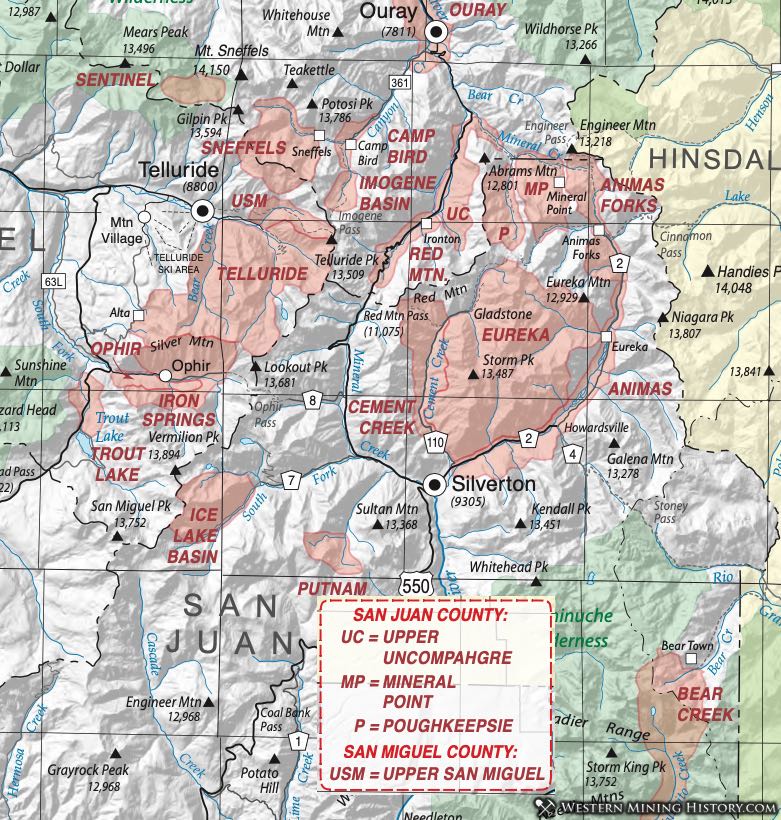
Animas District
The Animas District was listed by Henderson (1926) as synonymous with the Putnam District. Dunn (2003) delineates the district as occupying both sides of the Animas River valley northeast of Silverton, reaching two miles above Howardsville where it abuts the Eureka District. However, Varnes (1947) in Vanderwilt (1947) describes the Animas District as the mineralized area south and east of Silverton in a belt several miles wide on the rim of the Silverton Caldera. It has also been referred to as the Silverton District.
Gold was discovered in Arrastra Gulch in the early 1870s, but the area didn't boom until the 1880s. Development was aided by the railroad which came to Silverton in 1882. The district was a major producer into the 1950s and produced gold and silver placers in the 1930s.
The geology is predominately pyroxene andesites within the caldera. Productive veins extend to the south rim of the caldera. Secondary fractures are concentric to the caldera structure, intersecting the radial fractures. Several different mineralization types are present (Varnes, 1947; 1963).
The town of Howardsville (aka Bullion City) supplied both the Animas and the Eureka Districts.
Animas Fork District (aka Eureka District)
Vanderwilt (1947) uses this name to refer to the Eureka District, as does Mindat.org. Refer to the Eureka District write up for more information.
Bear Creek District
The Bear Creek district is a small district about 19 miles east of Silverton. It lies across the Continental Divide near the border of La Plata and Hinsdale Counties. According to Dunn (2003) it encompasses the headwaters of Bear Creek (a tributary of the Rio Grande River) and Vallecito Creek (a tributary of the Los Pinos River). Mindat.org also uses the name Beartown District.
Vanderwilt (1947) describes narrow white quartz fissure veins containing gold and silver tellurides and other minor sulfides. Vanderwilt identifies petzite as the telluride and mindat.org adds calaverite.
According to Eberhart (1969) the town of Beartown rose up after a big strike in 1893. The district was a rich, although smaller, producer well into the 1900s.
Cement Creek District
The Cement Creek District is included in the Eureka District as described under that heading. Mindat.org indicates the same, but does list mines and minerals exclusive to that part of the district. The website indicates that "all but the southern part of the Cement Creek District lies within the Eureka District." Burbank and Luedke (1969) include a small section on the "Cement Creek-Bonita Peak" area in their paper on the Eureka District. In their description, they include the Gold King Mine and the Bonita vein, iconic mines of the San Juan Mountains in general.
Eureka District
The Eureka District was recognized by Henderson (1926) and by Vanderwilt (1947). The latter considered the district synonymous with the Cement Creek, Mineral Creek and Animas Forks Districts. Dunn (2003) noted that it has also been called the Silverton District. Moore (2004) provided boundaries - from "the abandoned town of Eureka north along the valley of the Animas River to the ghost town of Animas Forks, west along the valley of the West Fork of the Animas (California Gulch) and across the divide into the drainage of Cement Creek above the abandoned townsite of Gladstone, and from Gladstone easterly along Eureka Gulch to Eureka. He also notes that the reference to the district has often been expanded to include the Mineral Point and Engineer Districts.
The district lies entirely within the Silverton Caldera with the dominant structural feature being the Eureka Graben, in the center and northeastern parts of the district. The boundary faults (and associated fractures) of the graben helped localize the ore deposition (Moore, Ibid).
Two types of deposits are found - veins and chimneys. The vein deposits are themselves of several types, according to Varnes and Burbank (1947). Quartz-pyrite gold veins with some galena and other sulfides in white quartz with abundant pyrite and some free gold are characterized by the Gold King Mine. A second type is the tungsten-bearing quartz veins. Massive pyrite veins also exist. Another variation is pyrite veins (such as the Brooklyn Vein) with some chalcopyrite and other base metal sulfides with a bit of quartz.
Chimney deposits are similar to those in the Red Mountain District. A good example is the Zuni Mine, characterized by a pipe sixty feet long and fifteen feet wide with massive anglesite, guitermanite (lead- arsenic sulfide) and argentiferous enargite. Some gold occurs in the pyritic ore.
Gold was first discovered in 1860 at Eureka and lode discoveries followed, leading to the development of the district by 1874. The Eureka and Silver Wing Mines were working by 1875. The Gold King vein was discovered in 1887. The largest producer by far was the Sunnyside Mine. According to Moore (Ibid) the Sunnyside was eventually connected to other large producers - Gold King, Gold Prince, and Great Mogul - by the American Tunnel.
The Sunnyside Mine and mill was served by the town of Eureka, a now-dead town. As many as 2000 residents called Eureka home at one time (Eberhart, 1969) and the Sunnyside mill alone employed 500. The mighty Gold King Mine was served by the town of Gladstone.
George Moore, a veteran geologist of the area, points out that most of the mines have been explored to only shallow depths and considerable mineralization probably remains in the area (Moore, Ibid.)
A large volume of literature has been generated on the geology and mineralization in the Silverton area. Aspects of the geology have been discussed by Lipman (1976), Lipman et al. (1978), Luedke and Burbank (1987), Plouff and Rakiser (1972), Steven (1975), and Steven and Lipman (1976). Ore deposits and mineralization have been discussed by Prosser (1910), Bejnar (1957), Burbank (1940), Burbank and Luedke (1968), Casadevall and Ohmoto (1977), Fischer et al. (1973), Grauch et al. (1985), Sanford et al. (1987), King and Allsman (1950), Rosemeyer (1988), and Mosier et al. (1986), among others.
Ice Lake Basin District (aka Ice Lake District)
Vanderwilt (1947) mentions the Ice Lake Basin District as adjoining the Ophir District in San Miguel County along the South Fork of Mineral Creek. Mindat.org also includes the district. It is mentioned in Worcester's paper on molybdenum occurrences (Worcester, 1919).
According to Eberhart (1969) and Dunn (2003), the leading mines were the Esmerelda and the Bandora. The former continued working long after the rest of the district declines.
Mineral Point District
The Mineral Point District is named for a mineralized knob of rock near the Bill Young Mine (Moore, 2004). It lies in a heavily-mineralized area of abundant mines where several named districts meet (or overlap). The boundaries of the district were defined by Kelly (1946) as Poughkeepsie Gulch on the west, Engineer Mountain on the north, the California Gulch divide on the southeast and the Canadian Lake Basin on the southwest. This constitutes about 3 1/2 square miles of relatively flat terrain - glacial moors of lakes, ponds, swamps and meadows between 11,500 and 12,500 feet in elevation (Moore, Ibid). In fact Moore shows the district as lying almost entirely in San Juan County, extending slightly north across the Ouray County boundary adjacent to the Engineer Mountain District.
Burbank described the area in Vanderwilt (1947) as containing vein swarms extending out from the Silverton Caldera, with more than 100 miles of vein outcrops mapped. To the east, these veins are a part of the Eureka District. The dominant rock is porphyritic andesite of the Burns member of the Silverton volcanics. Deposits were of three types: fissure and cavity fillings, breccia chimney and dike deposits, and replacement deposits (Burbank, 1947). The principal mines were shafts, mostly less than 300 feet deep (Burbank and Luedke, 1969).
Burbank describes the veins as mostly quartz with pyrite, sphalerite, galena, chalcopyrite, rhodochrosite and barite. (Note that Burbank includes several separate districts in his single description.) Precious metal mineralization is distinct from the base metals, with gray quartz with argentiferous tetrahedrite, some ruby and brittle silver (stephanite, proustite/pyrargyrite) and some native gold. More detailed descriptions can be found in papers by Hazen (1949), Hon et al. (1986), Kelley (1946), King and Allsman (1950), and Yager and Bove (2002).
The town of Mineral Point was a bustling center for a short while, serving mines in the Mineral Point, Engineer Mountain and Poughkeepsie Gulch districts (Eberhart, 1969). Nearby was American Flats (later called Engineer City). Histories of these two towns can also be found in Eberhart (Ibid).
Poughkeepsie District
The Poughkeepsie District spans the county line with Ouray County. Refer to the district write up in Ouray County.
Red Mountain District
Refer to the Red Mountain District in Ouray County.
Upper Uncompahgre District
Refer to the Upper Uncompahgre District in Ouray County.