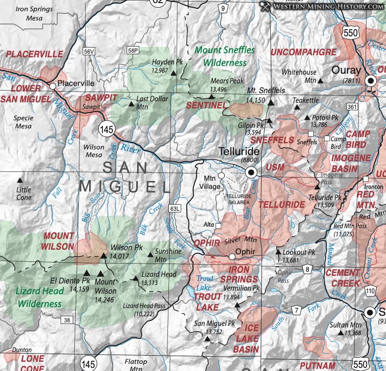
Iron Springs District (aka Ophir District)
The Iron Springs District was located at Sections 25-36, T. 42 N., R. 9 W; Sections 1-4 and 9-12, T. 41 N., R. 9 W. of the New Mexico principal meridian (Henderson 1926). It is located about 10 miles south of Telluride. It was also referred to as the Ophir District, which was the preferred name by Vanderwilt (1947). Dunn (2003) indicates that the district may include or overlap with the Trout Lake District to the southwest. The Iron Springs District was one of the original six main districts of San Miguel County, but by 1898 it was one of four districts (Dunn, 2003). It is a former gold, silver, lead, copper and zinc mining area and the Alta Mine was one of the biggest producers (Dunn, 2003).
Claims were being made by the mid 1870’s. Mines were operating in the valley and shipping silver ore by 1878. Several mines, including the Alta Mine, were being developed by 1881. An unsuccessful smelter was built in Ames in 1883. The district was driven by silver prices and most mines only operated intermittently. The district was mostly inactive from 1930-1936, but was very active from 1937-1948, and inactive since then (Dunn, 2003).
The mining camp of Ophir, a short lived mining camp, was located on Ophir Creek in Ophir Valley (Eberhart, 1969) at approximately the center of the District. The small town of Iron Springs was east of Howard’s Fork (later Ophir, New Ophir) (Dunn, 2003). Eberhart (1969) indicates that the small village of Iron Springs was a short distance from Old Ophir, towards Ophir Pass, and that besides mining it was also a resort community.
Lower San Miguel District (aka Placerville District; aka Sawpit District)
Henderson (1926) lists the district as being located at T. 44 N., R. 11 W. and T. 43 N., R. 10 W. of the New Mexico principal meridian. Vanderwilt (1947) and mindat.org refer to the Lower San Miguel District as including the Placerville, Sawpit, and Newmire Districts, having commodities of silver, gold, lead, copper and vanadium. Mindat.org also has a separate listing for the Placerville District. Placerville is located 14 miles northwest of Telluride, and Sawpit and Newmire Districts are located between the two along the San Miquel River valley (Vanderwilt, 1947). Heyl (1964) reports that the Placerville District was centered near Sawpit along the San Miguel River.
The Sawpit mineralization is located along an 8-foot bed of limestone. Commodities included silver and gold with lead. Gold placering along the river consisted of small sluicing operations which yielded relatively little gold, due to the fine gold being widely distributed (Vanderwilt, 1947). Parker (1968, 1974) indicates that the placering extended nine miles downstream from Sawpit and that Placerville was at the center of this area.
Most of the Placerville area is underlain by nearly horizontal sedimentary beds of Permian to Cretaceous age, which have been intruded by Tertiary igneous rocks and cut by numerous faults (Fischer, 1968). The district is located west/northwest of the Silverton Caldera (Vhay, 1962). In the Placerville Quadrangle, the Entrada sandstone of Late Jurassic age contains tabular deposits of vanadium with subordinate uranium, and the Pony Express limestone member of the Wanakah formation contains bedded replacement deposits of gold- and silver-bearing pyrite. Fischer (1968) provides a map with roughly north/northwest trending chrome- and vanadium-bearing belts in and around Placerville and Sawpit.
Copper-bearing veins, containing varying amounts of "hydrocarbon" (solid members of the petroleum group), follow northwestward-trending normal faults; in places some of the hydrocarbon is uranium bearing. Sporadic attempts have been made to produce both copper and uranium from these deposits (Bush et al., 1959). Gold-bearing placer deposits are present along the bottom of the San Miguel River valley and in elevated terrace gravels as much as 200 feet above the present stream level (Parker, 1968). Some gold was produced from the placers late in the 19th century and early in the 20th (Bush et al., Ibid).
Towns in the district include Placerville (named for the placering operations), and Sawpit (named for the nearby creek). The city of Placerville was originally located about 1.5 miles away, and was plated with cabins in 1877. However, a young fellow built a general store and saloon at the current location and the first settlers pulled up their stakes and buildings to relocate around the store and saloon. Much of the business section of Placerville burned in 1919, but was rapidly rebuilt. Placerville boomed after ranching came into its own and it is a top livestock shipping point in western Colorado (Eberhart, 1969).
Sawpit came into being as a result of a blacksmith who located good ore in 1895. He named his mineral claim the Champion Belle and mined it for gold and silver. Small quantities of smithsonite were found in its deeply oxidized ores (Heyl, 1964). The town was laid out in 1895 and several wood frame buildings were built (Eberhart, Ibid).
Mount Wilson District
The Mount Wilson District is located 12 miles south of Newmire. Mineral commodities included gold, silver, lead and copper.
The principal mine was the Silver Pick, which is located high on the rugged ridge at the head of Silver Pick Basin just west of Wilson Peak. Despite its name the principal product in value was gold. Bromfield and Williams (1972) have an extensive discussion about the mine and its production.
The Silver Pick vein, which is 3-6 inches wide, trends N. 40° to 60° E. and dips about 75° SE.; it cuts microgranogabbro, grandiorite, and porphyritic quartz monzonite of the Wilson Peak stock. The most productive part of the vein was in granogabbro. The principal sulfide minerals in the vein are pyrite, chalcopyrite, and arsenopyrite. Galena and sphalerite are present, but are not conspicuous in the vein material. The gangue is chiefly white crystalline quartz, carbonate minerals, and, possibly, some barite. The gold is apparently very fine grained and, like that in many gold districts, it is closely associated with arsenopyrite and chalcopyrite. Silver exceeds gold in the ore by a ratio of 3 to 1 (Bromfield and Williams, 1972).
Telluride District (aka Upper San Miguel District)
The Telluride district was a former gold, silver, lead, zinc and copper mining district located in the western San Juan Mountains, in the Uncompahgre National Forest. Prospecting resulted in the district being discovered in 1875, specifically gold in the Sheridan and Smuggler veins (Dunn, 2003). Henderson (1926) lists the Upper San Miguel District, but places a Telluride District (aka Frying Pan District) in Eagle County. Vanderwilt (1947) referred to the district as the Upper San Miguel District. Fisher (1990) includes the Telluride District with the Sneffels and Camp Bird Districts as one district.
The district’s principal mines were the Liberty Bell Mine, Smuggler (of Smuggler Union), and the Tomboy. These three produced much of the district’s gold and silver, making it one of the 25 top leading gold producers in the U.S. The Tomboy and the Smuggler supported their own mining camps that housed hundreds of miners (Dunn, 2003). The Liberty Bell Mine closed in 1921, the Tomboy Mines in 1927, and the Smuggler-Union Mines in 1928. However, in 1940 the Tomboy and Smuggler-Union were consolidated and worked through the 1950s.
Mineralization is generally comprised of polymetallic veins. Controls for ore emplacement include the types of wall rock, vein intersections, character of fault movement, presence of intersecting dikes and faults, and abrupt changes in strike or dip. Local alteration is propylitic (caused by iron and magnesium bearing hydrothermal fluids, altering biotite or amphibole to epidote–chlorite–albite such that veining or fracture fill with the mineral assemblage along with pyrite). Volcanic rocks are propylitically altered with epidote, calcite, chlorite, pyrite, sericitic, argillic, and calc-silicate alteration near the veins; quartz-pyrite- sericite, kaolinite, and epidote-rich calc-silicate skarns. Local rocks within the district are comprised of Eocene pre-volcanic sedimentary rocks. Local geologic structures include a NW-trending swarm of dikes, fissures, and veins radiating from the Silverton Caldera, forming a belt of fracture zones, ring faults and dikes, cone sheets, and radial dike swarms.
The town of Telluride, which was originally called Columbia, was established in 1878 along the San Miguel River. The town of San Miguel City was established west of Telluride (about 1 mile down river) in the mid 1870’s due to promising gold and silver discoveries, but by the early 1880’s most of the inhabitants had moved to Telluride (Dunn, 2003). This was due to Telluride being located closer to the better producing mines (Eberhart, 1969). Eberhart (Ibid) provides a rich history of the town, including some of the notable people and union wars that occurred in the early 1900’s. The district also included the camp of Savage Basin (Dunn, 2003).