Avalanche District
Refer to Lincoln District and Breckenridge District.
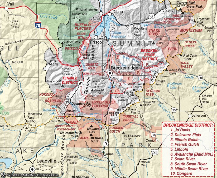
Breckenridge District
The Breckenridge District covers a large area, defined by Ransome (1911) as all the territory drained by the Blue River and its tributaries above the confluence with the Snake River and Tenmile Creek near Dillon. Vanderwilt (1947) seems to refer to it alternatively as the Bevan District. On our map, we break out the smaller districts, including placers, along the Swan River. Those districts include the following:
- Jo Davis
- Delaware Flats (placer)
- Union (placer)
- Illinois Gulch (placer)
- French Gulch (placer)
- Lincoln (aka Avalanche)
- Avalanche (Bald Mountain)
- Swan River
- South Swan River
- Middle Swan River
- Congers
The Breckenridge District is primarily known as a gold-producing district, although some silver was found. As was usually the case, the earliest activity was placer, but then lodes were found and hard-rock mining activity picked up. Lead-silver lodes produced early, and notably the Wellington Mine yielded ore until 1929. Lode gold and silver were mined until 1942.
The Breckenridge District includes the well-known Farncomb Hill, where some of the largest discoveries were made in Summit County, and the famous Wire Patch Mine. In 1879, lode deposits were first discovered on the northeast side of Farncomb Hill. These lode deposits probably supplied French Gulch (on the south side of Farncomb Hill) and the American Gulch placers (on the north side of Farncomb Hill).
Precambrian schist, gneiss and granite and sedimentary rocks ranging in age from Proterozoic to Cretaceous are intruded by early Tertiary monzonite and quartz monzonite porphyries (Vanderwilt, 1947). Most ore occurs in small veins in the monzonite or in Dakota Quartzite, although veins can be found in all the bedrock types. As noted, placers were most important, but contact metamorphic deposits and stockworks are also found.
Extensive detailed histories of both mining and settlement can be found in Ransome (1911), Eberhart (1969) and Gilliland (2006).
The Breckenridge District grew where the first miners pushed across the Continental Divide in Colorado in 1859 from South Park (Tarryall). Rich placers were first discovered on Farncomb Hill. For some time, activity was concentrated on the north slope of that feature. Ransome (Ibid) quotes an early report that Georgia Gulch alone produced $3 million in gold by 1862. Vanderwilt (1947) estimated some 750 million ounces were recovered by the mid-twentieth century. It wasn't long, however, until intrepid prospectors branched out and found significant gold on the French Creek side of Farncomb Hill and other production opened up.
Early in its history, a small fort was erected because of rumors of hostile Ute Indians. The fort was deserted and a town founded soon after (with the fascinating story told by Gilliland, Ibid). The town was named Breckinridge for political reasons (named for the Vice President of the US). When that politician announced for the southern cause in the Civil War, however, the first "i" was changed to an "e" and the town of Breckenridge was born.
Additional references include Henderson (1926) and Lovering (1934).
Chihuahua District
The Chihuahua District includes the area around the town of Chihuahua and Chihuahua Creek - a tributary to the Middle Fork of the Snake River, northeast of Montezuma. The District is listed by Henderson (1926) and Dunn (2003), but is not specifically described in any of the other major references on Summit County.
Among the mines listed in Dunn (2003) as representing the district, the Maid of Orleans Mine (and vein) are described, in Lovering (1935) on the southeast spur of Lenawee Mountain about a mile northeast of the town of Montezuma. The Eliza Jane is listed with the American Eagle Mine (in the Peru Creek Area) in mindat.org and described in Lovering and Goddard (1950).
Silver was discovered in the area called Chihuahua Creek in 1878 (Gilliland, 2006) and the Chihuahua Mining and Milling Company incorporated the following year to process ore from the find. The town of Chihuahua became one of the largest in the area (Eberhart, 1969).
Congers District (aka Upper Blue River District)
Henderson (1926) lists the Congers District as part of the Breckenridge District. An additional reference is Gilliland (2006).
Activity started in 1879 when lead-silver veins in carbonate - said to be like those in Leadville - were discovered. The rush didn't last long and the mining activity soon died out. The geology noted by Singewald (1951) at the Warriors Mark Mine showed Pennsylvanian and Permian sedimentary rocks intruded by a monzonite, forming conformable bodies. As best he could tell at the time, most of the mineralization occurred in fissures in a thin limestone with galena, barite, a pinkish carbonate, limonite, malachite, cerussite, and quartz.
Delaware Flats District
This placer district is included in the larger Breckenridge District. It is the area between the lower Blue River and the lower Swan River, adjacent to the Jo Davis District. It probably overlaps with the Swan River District. Parker (1974) quotes several publications at the time of the mining which mention the Delaware Flats area. The town of Delaware Flats lay between the Blue and the Swan Rivers, near the mouth of Silver Creek (Eberhart, 1969). Gilliland also notes that the old name of Delaware Flats was Buffalo Flats (Gilliland, 2006). The town housed a post office in 1861.
Parker also quotes an old source that seems to equate Delaware Flats with Buffalo Flats, a highly productive area included here within the Consolidated Union District, further indication of the confusion of all the small districts in the area.
French Gulch District
Vanderwilt (1947) included the French Gulch District as part of the larger Breckenridge District.
French Gulch empties into the Blue River just north of the main town of Breckenridge, running twelve miles from French Pass, with tributaries Gibson, Negro, and Corkscrew Gulches. This was also originally a placer district, although it runs past the famous Farncomb Hill and its lode mines, including the famous Wire Patch Mine. While miners diligently panned and sluiced the gulch, Harry Farncomb noted vein gold on Farncomb Hill and began buying up land. In the early 1860s, however, his secret leaked out when he plopped a large sack of gold onto a counter in a Denver bank. This precipitated a land war called the "Ten Years War," over the land ownership, a story which is skillfully related in both Eberhart (1969) and Gilliland (2006).
The Wire Patch Mine is described as a metallized breccia zone (Ransome, 1911) where a quartz monzonite porphyry intruded a dark shale that forms the Farncomb Hill. The veins on Farncomb Hill were notably narrow, seldom exceeding a half inch in width. The Wire Patch has long been famous among mineral collectors for its fantastic crystallized gold. Samples are still bought and sold among collectors and populate the better mineral collections at museums around the world.
Frisco District
The Frisco District occurs near the town of Frisco at the northern end of the Consolidated Tenmile District. (The Tenmile District is considered by most to include the Frisco, the Kokomo, the Robinson and the Wilkinson Districts.) It was listed by Henderson (1926) and Dunn (2003). Vanderwilt (1947) described the Frisco district as lying within the Tenmile Canyon - a steep-walled canyon in Precambrian gneiss and schist with easily-identifiable veins. He considered the veins generally too small to be productive. The district produced mainly gold, but sphalerite and galena have been found in the dumps.
The town of Frisco was significant in 1880, but withered several years later. Revived somewhat in the 1890s, it spurted in growth again in 1932 (Eberhart, 1969). Gilliland (2006) describes in detail the location of many of the historic mining features around the current town of Frisco.
The District was never a significant producer. The major commodity was gold, trace commodities included zinc, silver, lead, and copper. An additional reference is Hollister (1867).
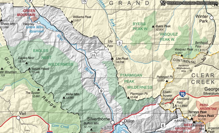
Green Mountain District (aka Wilkinson District)
Henderson (1926) recognized the Wilkinson District, which Vanderwilt (1947) equated to the Green Mountain District. This is a small district, which Dunn (2003) places far to the south of Henderson's location, extending into Eagle County. Gold, silver, copper, lead and zinc are present (Dunn, 2003).
Vanderwilt (Ibid) says the district occurs along the Blue River 12 miles south of Kremmling, just east of the Green Mountain Reservoir. Mineralization occurs on the west slope of Green Mountain where a vein occurs at the contact of a quartz monzonite sill with Mancos Shale (and possibly Dakota Quartzite). The discovery was in the mid-twentieth century and it maintained small production.
Hoosier Gulch District (aka Hoosier Pass District)
According to Henderson (1926), the Hoosier Gulch District overlaps the Pollock District. Lying along the Park-Summit County line, the district consists of historic placer operations at the headwaters of the Blue River (Dunn, 2003). It bounds the Upper Blue River District to the north. It is interpreted to include the mines discussed in the paper by Singewald (1951).
Parker (1974) describes the Bemrose and Bostwick Placers as producing from 1871 to 1877 and again sporadically from 1914 to 1922. Singewald (1951) describes the Bemrose Mine, in addition to the productive placer, as consisting of a shaft into mineralized rock consisting of replacement deposits in Pennsylvanian rocks. The mines of Monte Cristo Gulch are also included in the Hoosier Gulch District. The Monte Cristo Mine also produced a small amount of gold and silver from a lode deposit possibly in Dyer Dolomite.
Illinois Gulch
The Illinois Gulch District is included in the Breckenridge District by Vanderwilt (1947). Ransome (1911) describes the Illinois Gulch placers as being worked by hand early in the history of the area. A large pit was excavated in the area by hydraulic mining. Parker (1974) notes that a bedrock shaft was started in Illinois Gulch in 1898, but no other mention is made of anything but placer activity.
Jo Davis District
The Jo Davis is one of the smaller districts that make up the large Breckenridge District. It may be what is referred to in Parker (1974) as the "Jeff Davis Patch", although Parker’s map (1992, page 47) shows the" Jeff Davis Patch" in French Gulch. (This further exemplifies the confusion in the old names.)
Vanderwilt (1947) places the Jo Davis District near Delaware Flats on the lower Blue River. It probably extended beneath what is currently Dillon Reservoir on the downstream end and to the town of Breckenridge on the upstream end.
Kokomo District (aka Tenmile District)
The Kokomo District was first named by Hollister (1867). It was listed by Henderson (1926) as one of the smaller districts comprising the Consolidated Tenmile District, which also included the Wilkinson, Frisco, and Robinson Districts. On the website www.mindat.org, the Kokomo District is considered synonymous with the Tenmile District, extending into Eagle County. Vanderwilt (1947) equates the Kokomo District to the Robinson and Tenmile Districts. Vanderwilt (Ibid) notes that the mines lie mainly west of Kokomo, but that the mineralized area extends to the northeast and to Robinson, five miles to the southwest. Dunn (2003) restricts the district to the area around the town of Kokomo on Tenmile Creek.
Koschmann and Wells (1946) and Koschmann (1947) describes the Kokomo/Tenmile District as lying immediately north of the Continental Divide near the headwaters of Tenmile Creek, with the Tenmile Range on the south (Mosquito Range) and the Gore Range on the north. He says the district was a minor producer of lead, silver, and gold from oxidized ores; later more zinc was recovered from unoxidized ores. Activity waxed and waned and nearly died from 1923 to World War II, but was reinvigorated with the demand for zinc in the war years.
The rocks of the district are Precambrian, and Paleozoic intruded by porphyries of late Cretaceous/Early Tertiary age. The primary ore horizons lie within limestones of Pennsylvanian-Permian age, which occur in thin beds spaced through the stratigraphic sequence (Koschmann, 1947). The ore occurs as one of two types: sulfide replacement deposits in limestone and sulfide veins in siliceous rocks. Most of the production was from the former.
Additional references include Bergendahl and Koschmann (1971), Eberhart (1969), Emmons (1898), and Gilliland (2006).
Lincoln District (aka Avalanche District)
While Henderson (1926) clearly defines the geographic extent of the Lincoln District as occupying two sections (1 and 2 in T7S, R77W), there are so many names associated with this area, and with neighboring and overlapping districts being better known, this district is virtually undefined geographically. Henderson (1926) lists both the Lincoln and the Avalanche Districts. He states that the Lincoln District overlaps the South Swan District, the Minnesota District, and the Avalanche District. He describes the Avalanche District as also called the Bald Mountain, Carpenter, Lincoln or Swan River District. In Vanderwilt (1947), neither the Lincoln nor the Avalanche is named specifically.
Middle Swan District
Considered part of the larger Breckenridge District, Henderson (1926) considers this district synonymous with the Rexford and Missouri Districts.
The Middle Fork of the Swan River comes from the east where, near timberline, the town of Swandyke serviced the old mines (listed below) in the 1890s. An additional reference is Eberhart (1969).
Minnesota District
The Minnesota District is within the Breckenridge District, but poorly defined. In mindat.org, this district is said to overlap Lincoln, Bevan and McBarnes Districts. In Henderson (1926) it is said to overlap the Bevan and Utah Districts. Refer to the Lincoln District.
Montezuma District
In Vanderwilt (1947), the mineralized area that comprises the Montezuma District extends two to five miles from the town of Montezuma east to the Continental Divide. With prospectors concentrating on gold deposits, silver was not thought of until the first silver lode in Colorado was discovered in 1864. A prospector named Coley came down Georgia Pass from South Park, headed up the North Fork of the Swan River (in present day Summit County) to Glacier Peak and there made his silver discovery. More prospectors followed on the news and silver was discovered here and in the Argentine District. The Gus Belmont was the first recorded lode in Colorado (Lovering, 1935).
Not much occurred in the Summit County area until 1879 when the villages of Chihuahua and Decatur arose in the valley of Peru Creek northeast of Montezuma. Montezuma itself had been settled in 1865 and has been there ever since. While the area was first worked in the early 1860s, it was always inhibited by its severe climate (at 10,000 feet) and difficult access.
Patton (1909) found the mineralization consisted of two vein systems. While lead, zinc, and some copper is present, most of the value was always in gold and silver. Silver was mainly in the form of ruby silver (prousthite - Ag3AsS3 or pyrargyrite - Ag3SbS3), brittle silver (stephanite - Ag5SbS4) and native wire silver (simply metallic native silver). Other silver minerals in the district are listed below.
Eberhart (1969) and Gilliland (2006) provide interesting stories and anecdotes about the town of Montezuma and other towns and camps within the district. Additional references are Goddard (1947) and Lovering and Goddard (1950).
Pollock District (aka Pollack District; aka Pollard District)
The Pollock District is named in Henderson (1926) and Dunn (2003). There is no specific information on the district or its mines, as those seem to be included in other nearby districts by different authors. Therefore, we assume the mineralization and the mines of the Pollock District are included either in the Tenmile District (Koschmann, 1947) (and possibly its sub-districts) and the Upper Blue River District (Singewald, 1951).
Robinson District
There is no clear boundary between the Robinson District and the Kokomo District. The Robinson District was included in the Consolidated Tenmile District by both Henderson (1926) and Vanderwilt (1947). Bergendahl and Koschmann (1971) didn't recognize the Robinson District, but included the entire area south of Copper Mountain in the Kokomo-Tenmile District. For our purposes, we will consider the Robinson in general, to lie to the south of the town of Kokomo, including the former townsite of Robinson, and to extend to Fremont Pass.
Gold was first discovered in McNulty Gulch by prospectors pushing over Fremont Pass from Leadville (Gilliland, 2006). The finds included the Justice Lode between McNulty and Gilpin Gulches. The town of Robinson was founded by George Robinson and was a large population center for a short time, the home of large milling and smelting capacity, with some 2000 occupants in 1880-81 (Eberhart, 1969).
The original Robinson holdings date back to late 1878. Mineralization occurred in limestone beds of the Minturn Formation, where replacement deposits created rich silver-bearing ore in three separate beds. Bergendahl and Koschmann (Ibid) quote an 1881 article in Engineering and Mining Journal stating that one of the ore bodies averaged 66.7 ounces silver per ton, but some assays exceeded 400 ounces per ton. Additional information can be found in the 1942 USGS map on the Tenmile Mining District, which has been superseded by Bergendahl and Koschmann (1971).
Most of the old Robinson District is now buried beneath tailings from the giant Climax Mine on Fremont Pass.
Snake River District
According to Dunn (2003), the Snake River District is generally synonymous with the Montezuma District, as indicated by Vanderwilt (1947). The Snake River District is listed under the Montezuma Area in mindat.org, separate from the Montezuma District (Snake River District).
The Lower Chataqua Mine, located on the website us-mining.com as a Breckenridge area copper and gold mine, is identified by mindat.org as lying within the Snake River District, is several miles south of the town of Montezuma.
South Swan District
Recognized by Henderson (1926) and is considered part of the large Breckenridge District. Dunn (2003) notes it as a rather small district, occupying sections 31, 32, and 33 of T6S, R73W. The district is along the South Fork of the Swan River, near Georgia Pass, where the first prospectors came across the Continental Divide and into present-day Summit County. It butts against the Georgia Pass District (which is generally not considered to be part of the Breckenridge District).
When a party of prospectors from Georgia pushed across "the Snowy Range" (as they called it) from South Park in May 1860, they crossed what they called Georgia Pass, down Georgia Gulch, to the South Fork of the Swan River. There, on the north side of Farncomb Hill, in Georgia Gulch, a very rich strike was made. Gilliland (2006) quotes totals of $10,000 made in the summer season, with a party of 4 miners producing $300 to $500 in gold per day (at a time when the standard wage was less than $2/day.) The rich placer gravels were soon exhausted, so lode mining took over. After that, hydraulic operations washed down the deeper gravels.
Eberhart (1969) describes the town of Parkville - founded in 1859 - as the largest in the area with as many as 10,000 residents at its apex. Residents used this little town as a commercial center for activity in the Swan River, Georgia Gulch and Georgia Pass areas. It was eventually buried under the tailings from the hydraulic operations.
Swan River District
This district is part of the large Breckenridge District. It runs the length of the Swan River upstream to the confluence of the Middle Swan. The best descriptions of the area are found in two books on the history of the area, by Eberhart (1969) and Gilliland (2006). Gilliland (2006) describes the locations along the Swan River. The river was extensively dredged. Very rich placer mining took place at Galena Gulch, where the North American Gold Dredging Company ran a large operation down to bedrock at the turn of the 20th century.
According to Gilliland, the next gulch upstream - Summit Gulch - was the site of the Hamilton Mine, operating from 1887 until 1910, with a ten-stamp mill, a tramway, flumes and its own reservoir. Swan City was located at the mouth of Brown's Gulch, with a population of 200 to 300 (Eberhart, 1969) during the 1880s. The DXL, New York, and Summit Mines were located there (Gilliland, Ibid). Up the North Fork of the Swan River were found the Rexford, the Rochester King (Arrastre King), formed from the original Black Swan, White Swan, Sweet William, Santa Claus and Ben Franklin claims.
Tenmile District
The Tenmile District was first identified by Hollister (1867) and described as all the sections drained by Tenmile Creek. It was listed by Henderson (1926) as the Consolidated Tenmile, and he included within it the Wilkinson, Frisco, Robinson and Kokomo Districts. On the website www.mindat.org, the Tenmile District is considered synonymous with the Kokomo District, extending into Eagle County. Vanderwilt (1947) equates the Tenmile District to the Robinson and Kokomo Districts. Vanderwilt (Ibid) notes that the mines are mainly west of Kokomo, but extend to the northeast and to Robinson, five miles to the southwest. Dunn (2003) describes the district as lying mainly in Summit County, but being large enough to extend into Eagle, Lake, and Park Counties. Two additional references are Eberhart (1969) and Gilliland (2006).
Koschmann and Wells (1946) and Koschmann (1947) describes the District as lying immediately north of the Continental Divide near the headwaters of Tenmile Creek, with the Tenmile Range on the south (Mosquito Range) and the Gore Range on the north. He says the district was a minor producer of lead, silver, and gold from oxidized ores; later more zinc was recovered from unoxidized ores. Activity waxed and waned and nearly died from 1923 to World War II, but was reinvigorated with the demand for zinc in the war years.
The rocks of the district are Precambrian, and Paleozoic intruded by porphyries of late Cretaceous/Early Tertiary age. The primary ore horizons lie within limestones of Pennsylvanian-Permian age, which occur in thin beds spaced through the stratigraphic sequence (Koschmann, 1947). The ore occurs as one of two types: sulfide replacement deposits in limestone and sulfide veins in siliceous rocks. Most of the production was from the former.
Union District (aka Consolidated Union District)
The Consolidated Union District is listed by Henderson (1926), although he provides no geographical reference. The district includes Gold Run Gulch downstream to Delaware Flats (and possibly to the Swan River). Parker (1974) describes it as including the very rich placer areas of Gold Run and Buffalo Flats. The former is said to have yielded 96 pounds of gold in its first season of work by the Weaver brothers, who first discovered it. Supposedly, the Buffalo Flats area yielded even more.
Note that the old reports imply that Buffalo Flats refers to the Delaware Flats area, which is listed here as a separate district (Eberhart, 1969; Gilliland, 2006).
Upper Blue River District
The Upper Blue River District is interpreted as encompassing the area of the upper Blue River, bounded on the south by the Hoosier Gulch District, on the west by the Pollock District, and extending downstream on the Blue River nearly to the town of Breckenridge, overlapping with the Congers District of the greater Breckenridge District to the north. Dunn (2003) describes the district as being centered on the common corner of four township blocks. Singewald (1951) describes the district as occupying 85 square miles. Vanderwilt (1947) describes it as adjoining the Montgomery District of adjacent Park County and states that it has not traditionally been listed as a district. So clearly the boundaries of the district are poorly defined, but the current configuration serves to encompass numerous small mines tapping widespread vein systems in the rock.
Singewald (1947) pointed out that the severe terrain of the district makes exploration and mining difficult. Many mines are "perched on cliffs that can be ascended only by aerial tramway or by foot". Ore deposits consist of veins - both fissure and replacement - in the Sawatch Quartzite, stratabound replacements and replacement veins in the Manitou and Dyer Dolomites and other calcareous beds, and as contact metamorphic deposits in the Morrison formation. Additional stringers are found in quartzite and in the intrusive porphyries themselves.
West Argentine District (aka Argentine District; aka Peru District)
The West Argentine District (a.k.a. Peru-Argentine District) crosses the Continental Divide from northeast Summit County into adjacent Clear Creek. Vanderwilt (1947) considers the Peru District of Summit County to be synonymous with the Montezuma District (refer to the Argentine District in Clear Creek County for further information). The West Argentine District is considered by Lovering and Goddard (1950) as that part of the Argentine District west of the Continental Divide.
Lovering and Goddard (Ibid) describe the district as a narrow belt (less than a mile in width) trending south-southwest from the Divide into Summit County. They account Pennsylvania, Delaware, Peruvian, Santiago, and Independence veins as making up the bulk of the district's output. Lead, silver, and gold were the principle constituents of the ores, but there was some zinc and copper.
The geology is characterized by Silver Plume Granite and Tertiary quartz monzonite, rhyolite, and dacite intrusions in the Idaho Springs Formation. Gold occurs in polymetallic veins of sphalerite-galena-pyrite- chalcopyrite + silver minerals (Lovering & Goddard, Ibid).