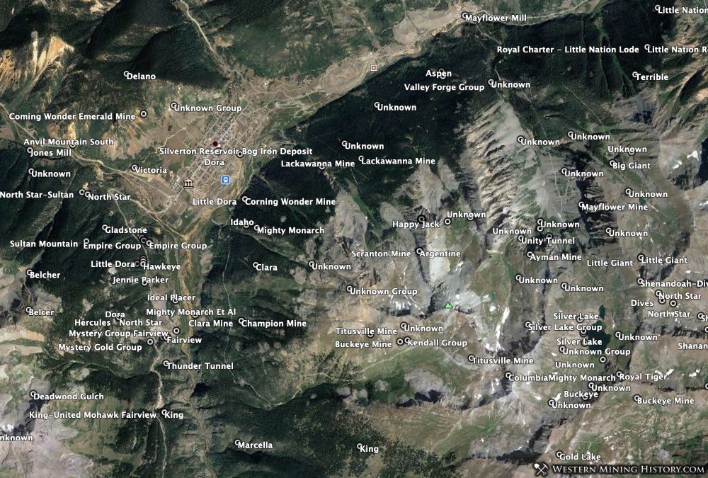
The WMH downloadable mine data package consists of KMZ and CSV data files for use with navigation devices, Google Earth, or for research purposes. The data source is the USGS MRDS database and contains records for mines of type “metallic” (does not include “non-metallic” mines). The WMH Mines Index package is a custom view of the MRDS data.
The KMZ files are organized by state and county and are ready to use in Google Earth Pro.
Click here to purchase the Expanded Index Mine Data product
About the USGS MRDS Mine Data
All mine locations were obtained from the USGS Mineral Resources Data System. The locations and other information in this database have not been verified for accuracy. It should be assumed that all mines are on private property.
Additional important notes on this mine data are available at the bottom of this page.
Mine Data Package Details
The data is organized into individual KMZ and CSV files for each county in the state. It is recommended that you use Google Earth Pro (the desktop version) rather than the browser-based Chrome version of Google Earth due to performance issues with large data sets.
The files contain the following number of records for each state. The records consist of mines, deposits, and occurrences:
Arizona (10,227)
California (34,956)
Colorado (13,388)
Idaho (8,197)
Montana (8,392)
Nevada (13,258)
New Mexico (4,122)
Oregon (7,991)
South Dakota (1,286)
Utah (8,309)
Washington (6,481)
Wyoming (3,325)
Mine Data Fields
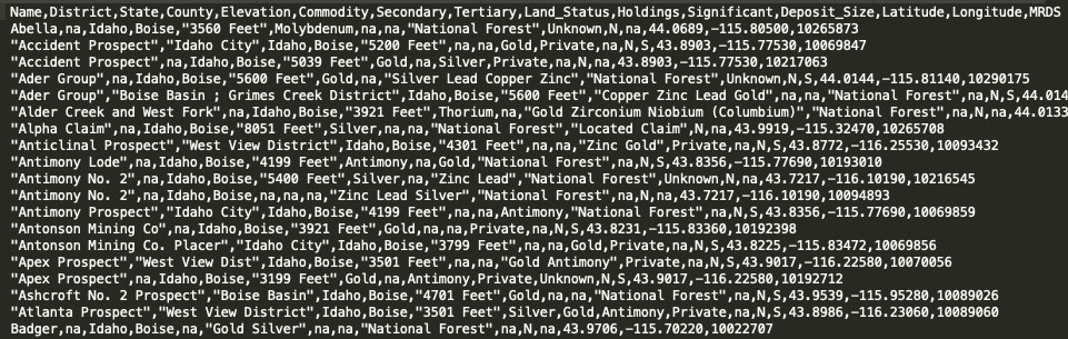
The Expanded Index mine data files contain the following fields for each record (where available):
mine name, district, elevation, primary commodity, secondary commodity, tertiary commodity, land status, holdings, significant, deposit size, latitude, longitude, county, MRDS mine ID.
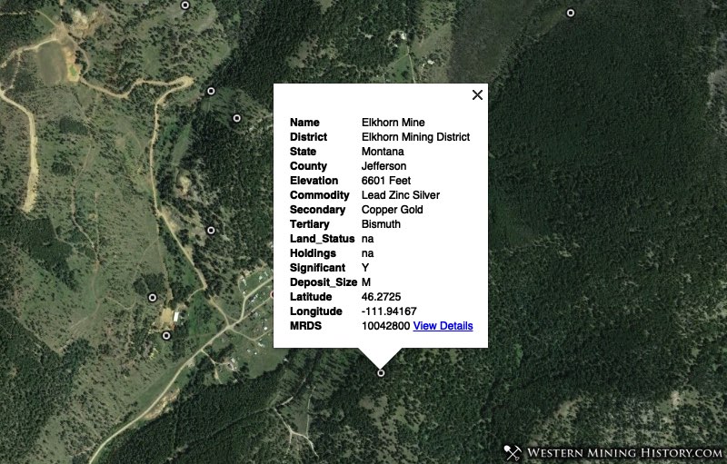
The following notes describe some of the fields used in the MRDS database:
Land Status: General category of land ownership. Note that just over half of the mines in the MRDS database have a value for land status. Important: the land ownership field only identifies whether the area the mine is in is generally on public lands like Forest Service or BLM land, or if it is in an area that is generally private property. It does not definitively identify property status, nor does it indicate claim status or whether an area is open to prospecting. Always respect private property.
Holdings: Type of mineral-rights ownership. Note that less than 10% of mines in the MRDS database have a value for this field so this should be used for reference only and not considered a complete record of holding types.
Size: Deposit size: Large, Medium, or Small. The tonnage of the deposit including all production, reserves, and resources. Note that only about a third of mines in the MRDS database have a value for deposit size.
Significant: Indicates whether the deposit has world-class significance. The criteria is total endowment of contained commodity, which includes all past production and reserves.
Important Information on MRDS Data
Although the USGS MRDS database contains a lot of valuable information, it is far from perfect. There are numerous duplicate mine records and records with bad coordinates. You can expect to see mines that are clearly in the wrong county or even sometimes the wrong state.
Despite these issues, the majority of the mine records are either precisely located, or at least located in close vicinity to the mine. Additional research using topo maps, USGS publications, or satellite imagery may be needed to find the mine features you are interested in.
It should be assumed that all mines are on private property unless research proves otherwise.
There are no refunds on digital products. These packages are intended for use in Google Earth Pro or GIS applications, they are not mobile apps. The KML files are in native Google Earth Pro format, and the CSV data can be imported to mobile apps or other GIS applications (it us up to the user to manage this data, we can’t support custom imports). Please contact us before purchasing if you have questions.