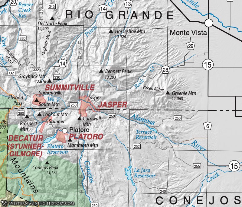
Decatur District (aka Decatur West District, aka Stunner District, aka Gilmore District)
The Decatur District is also known as the Stunner District, and was located along the Alamosa River. Mindat.org refers to the Decatur District as the Decatur West District (Stunner District). The district also included the Gilmore District located just south of the Stunner District (Patton, 1917). Henderson (1926) referred to the Decatur District as also being known as the Summit District and as occupying both Conejos and Rio Grande Counties. Here we have separated the Summit (Summitville) District due to being located in a separate county and having ores of different genesis and age (Steven and Ratte, 1960).
The camp of Stunner was said to have been opened in the early 1880’s, some ten years after ore was first discovered at Summitville, and grew rapidly until in 1890 it contained a population of about 300 (Patton, 1917). The Stunner camp was originally named Conejos Camp, then Loynton, before becoming Stunner in 1887 (Eberhart, 1969). One or two very promising mines were developed and a large number of claims staked out, and worked to a greater or less extent. Extremely rich silver ore seems to have been shipped from several of the properties, but the rich ore soon gave out, and the low-grade ores could not be worked with profit owing to the remoteness of the camp (Patton, 1917).
In October 1912, gold telluride was discovered on the west slope of Klondyke Mountain on a claim owned by Mr. Gilmore. The Gilmore claim was located about three and a half miles almost directly west of Platoro on the very steep northwestern slope of Klondyke Mountain, overlooking the Alamosa valley. It was two miles from the town of Stunner, located in this same valley. The gold telluride was reportedly much darker in color than is the case with the Cripple Creek tellurides. The crystals were usually invisible although they occurred disseminated through the quartz gangue and gave the ore a characteristic dark color. The rich gold telluride ore was worked by means of an open cut and found to continue for 10 or more feet. However, the ground became broken below this point and the ore ceased entirely and could not be found again because only barren quartz veins were encountered (Patton, 1917).
The geology of the area is igneous in origin. This district lies in the eastern part of the San Juan volcanic field and the late Oligocene-aged Platoro and nested Summitville calderas constitute a composite collapse structure of about 20 kilometers in diameter (Lipman, 1974; Steven & Lipman, 1976). Ore was found in mineralized epithermal quartz-latite veins that extended over long distances. Major commodities in this district were silver and gold, with minor to trace antimony, copper, iron, lead, molybdenum, and zinc.
The rock formation on the Alamosa slope of Klondyke Mountain consists entirely of monzonite with a very small area of monzonite porphyry. Andesite appears on the summit of the ridge above the Gilmore claim and from there extends eastward over the whole flat-topped summit of the mountain (Patton, 1917). The ore veins lie mainly in the Treasure Mountain latite and in part apparently in the overlying andesite.
The mines were primarily developed in quartz fissure veins. At the Eurydice Mine the quartz fissure vein contained streaks of pyrite and chalcopyrite, which carried sulfides and tellurides of gold and silver. The outcrop of the vein could readily be traced for several hundred yards up the gulch and was from two to four feet wide. It was stained brown by the oxidation of the iron sulfides. This mine had the distinction of producing shipping ore, but was not worked after 1893 (Patton, 1917).
The town of Stunner in the summer of 1913 had a half dozen or more houses in good condition and supported a store and U.S. Post Office (Patton, 1917). Gilmore was a brief camp founded in 1913 (Eberhart, 1969).
Platoro District (aka Axell District, aka Lake Fork District, aka Ute District)
The Platoro District is situated on the Conejos River and includes the former mining camps of Platoro, Lake Fork (adjoining to the south of Platoro) and Axell (two to three miles east of Platoro) (Patton, 1917). Patton (1917) and Henderson (1926) show that the Platoro District was also known as the Ute District. Vanderwilt (1947) used the Platoro District as the primary name. Dunn (2003) indicates that the Platoro District was also referred to as the Axell, Lake Fork, Gilmore or Stunner Districts. However, Patton (1917) shows the Stunner District as being part of the Decatur District situated along the Alamosa River; refer to the Decatur District for more information.
The geology of the area is predominately igneous in origin. This district lies in the eastern part of the San Juan volcanic field and the late Oligocene-aged Platoro and nested Summitville calderas constitute a composite collapse structure of about 20 kilometers in diameter (Steven & Lipman, 1976). Ore was found in mineralized epithermal quartz-latite veins that extended over long distances. Major commodities in this district were silver and gold, with minor to trace zinc, copper, molybdenum, lead and antimony.
The Mammoth group consisted of fifteen patented claims having a total area of 126 acres, and lying upon the northern slope of Mammoth Mountain. The Mammoth Mine, was known for silver ore, but also contained gold and telluride, and the ore was sourced from the Mammoth vein (Patton, 1917). This consisted of a quartz fissure vein with associated marcasite and Arsenopyrite and complex sulpho- telluride ore. The principal workings were on the Mammoth and Revenue claims that join each other end to end, with a main tunnel 1,600 feet long.
Patton (1917) reports that the Congress Mine consisted of seven claims with an area of 61.4 acres. It was located along the Mammoth vein, just south of the Mammoth Mine. Just north of the Mammoth Mine was the Parole Mine consisting of 2 claims with an area of 20.6 acres along the Mammoth vein. Also on the Mammoth vein was the Valley Queen Mine to the north of the Parole Mine. At this mine the mineralized quartz vein was reported to be 34 feet wide and contained a streak of 12 to 18 inch ore. The Merrimac Mine was located along 6000 feet of a separate vein roughly paralleling the Mammoth vein. The Forest King Mine, located on the western slope of Mammoth Mountain, was about one mile west of the Mammoth vein. Specimens of free gold were obtained from this vein.
A little molybdenite was found at the Merrimac Claim in a two-inch wide quartz vein, but was too small to be of commercial value. The host rock for this was granite and granitic gneiss (Worcester, 1919).
The town of Platoro was stated as being located at an elevation of 9,900 feet, in the midst of a flat, open expanse of the Conejos River valley that measures some half to three-quarters of a mile wide and three miles long (Patton, 1917). Platoro was one of the oldest towns in the area and had a population of 300 by 1890. However, as the ores were depleted, so was the town. There was a slight resurgence in the early 1900s and again just before World War 1, but these did not last. Currently, Platoro has become a tourist attraction (Eberhart, 1969). The Axell District and camp may have been named for Charles O. Axell, who prepared geologic maps of the area (such as Axell (1934)) and also the mining claim map included in Patton (1917).