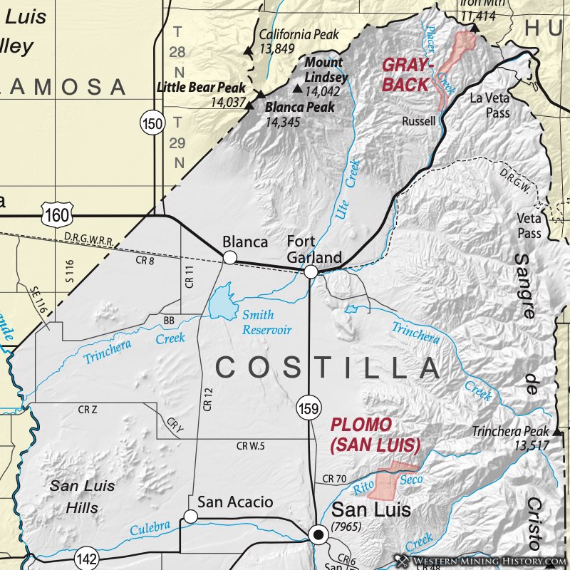
Grayback District (aka Russell District)
The Grayback District lies due east of Blanca Peak in northern Costilla County and has produced gold and iron. It is named for Grayback Mountain, which also called Iron Mountain because of the iron deposits on its western slope. The District sits within the Trinchera Estate of nearly 1/2 million acres - a land grant from the Mexican government in 1843. The Trinchera grant and the larger Sangre de Cristo land grant to the south came into the possession of Colorado Governor Gilpin.
The Grayback District is probably the location of the first mining activity in the State. Discussed in Parker (1974), soldiers from Fort Massachusetts appear to have been the first miners. The fort was established in 1852 on Ute Creek, approximately 6 miles north of the present-day site of Fort Garland. Soldiers worked the gravels of what has since been called Officers Bar in Placer Creek. Later, Chinese miners reportedly had success at the site.
The Trinchera Estate (on which the District occurs), received no income from the mining, so they closed the estate to all activity in 1877. Later, with procedures in place to permit mining on the land grant, mining resumed in 1896 and a company brought in a large steam shovel in 1898, but with little success. In 1910 the Colorado Gold Dredging Company introduced a steam dredge for Placer Creek capable of 2000+ tons per day. According to US Mine records reported in Parker (ibid), the dredge produced $21,454 in gold at the prevailing price, recovering 25 cents per yard.
Not much activity occurred from 1911 until the 1930s. In 1939 the district produced 19 oz of gold and 1 oz. of silver. Additional references are Dunn (2003) and Vanderwilt (1947).
The rocks of the Grayback District are Precambrian, mostly granitic gneiss. A steeply-dipping contact, roughly parallel to Placer Creek, is overlain by sedimentary rocks to the west. These are intruded by sills and dikes of porphyritic monzonite and felsite. Some contact-metamorphic iron ores have been mined in the district. The iron ores contain low-grade gold. Evidence indicates the presence of additional iron deposits in the area (Patton et al., 1910). Thin veins contain auriferous pyrite and chalcopyrite.
One of the more interesting aspects of the District is that the gold telluride calaverite (AuTe2) has been found in the gravels of upper Grayback Gulch (Patton et al., 1910). Did most of the abundant gold in the Grayback placers come from the low-grade iron ores or is there a yet-undiscovered source of richer gold- bearing telluride ore?
Plomo District (aka El Plomo District aka Rito Seco District)
The Plomo District is on Rito Seco Creek and the area to the south (Dunn, 2003). Vanderwilt (1947) referred to it as the Plomo District, but it was also identified as the El Plomo District or Rito Seco District by Henderson (1926).
An ore body was located in 1896 to 1897 which has some small gold production. A series of tunnels and shafts were known as the El Plomo Mine, which was owned by the Trinchera Estate Company (Dunn, 2003). The San Luis Mine was worked in the 1990s by the Battle Mountain Gold Company (Dunn, Ibid).
Additional references include: Benson and Jones (1990) and Widman and Kirkham (1999).