Alice-Yankee Hill District
The Alice District, on the northern border of Clear Creek County, extends into Gilpin County as the Alice-Yankee Hill District. (The Lincoln District is included here). This is a high-altitude district, elevation ranging from about 10,000 to 11,000 feet.
The Alice Mine was the first development, where free gold was captured using hydraulic methods in 1880. The gold came from a relatively low-grade auriferous pyrite body in a quartz monzonite stock (Vanderwilt, 1947; Parker, 1974). The Alice Mine reopened as a large open pit in 1933 with some underground workings.
Idaho Springs Formation schists are intruded by Precambrian Boulder Creek Granodiorite and later by a Tertiary stock of quartz monzonite. Gold-bearing stockworks in the quartz monzonite were the most valuable, along with quartz-pyrite veins in the Precambrian rocks (Lovering & Goddard, 1950). Lovering and Goddard also point out that significant promise remains for a large volume of sulfide ore south of the Alice Mine beneath glacial debris. An additional reference is Bastin and Hill (1917).
Argentine District
The Argentine District (a.k.a. Peru-Argentine District) crosses the Continental Divide in southwest Clear Creek County into adjacent Summit County, mostly on Kelso and McClellan Mountains (Lovering & Goddard, 1950). The Belmont Lode was discovered in 1864, and contained less gold than silver. A number of mines developed and the district was organized. After 1888, activity became intermittent. Additional references are Eberhart (1969), Ellis and Ellis (1983), Goddard (1947), Lovering (1935) and Spurr (1908).
The geology is characterized by Silver Plume Granite and Tertiary quartz monzonite, rhyolite and dacite intrusions in the Idaho Springs Formation. Gold occurs in polymetallic veins of sphalerite-galena-pyrite- chalcopyrite + silver minerals (Lovering & Goddard, Ibid).
Famous lead-silver veins included the Argentine, the Kirtley (or Curtly) and the Colorado Central (Vanderwilt, 1947).
Banner District
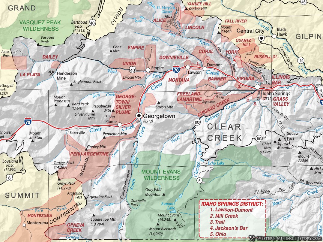
Described by Henderson (1926) as occupying section 38 [sic], T3S, R73W, Dunn (2003) places the Banner District "between South Clear Creek and Trail Creek, including the area around Turkey Creek". On our map, the district is placed in the area of approximately sections 28-29, 32-33. This is a district that was active in the very early years of mining in the Idaho Springs area and pin-pointing its exact location is impossible.
Dunn (2003) indicates that this was one of the original 29 districts organized in Clear Creek County and that gold placers were worked by mechanized operations as late as 1941.
Chicago Creek District (aka Jackson District or Jackson Bar District, aka Corral District)
The Chicago Creek District produced placer gold with silver, lead, gold, copper, and zinc. The District, in the watershed of Chicago Creek upstream (southwest) of Idaho Springs, shows polymetallic fissure veins. Harrison and Wells (1959) detail five separate types of veins: (1) pyrite (auriferous) + quartz; (2) auriferous pyrite + copper sulfides; (3) pyrite-galena-sphalerite with copper sulfides; (4) galena-sphalerite with subordinate copper and silver sulfosalts (the most common type); and (5) quartz-carbonates-galena- sphalerite. They occur in fissure veins and faults with the same general geology as the other districts nearby. Additional references include: Eberhart (1969) and Spurr et al. (1908).
Dailey District (aka Jones Pass District)
The Dailey District lies at the western end of Clear Creek County near the head of the West Fork of Clear Creek at Jones Pass. Vanderwilt (1947) also refers to it as the Atlantic District and Lovering and Goddard (1950) as the Jones Pass District. An additional reference is Dunn (2003).
Vanderwilt (Ibid) describes it as characterized by small veins with lead, zinc and some silver in Precambrian granite. Lovering and Goddard (Ibid) note that the Urad Mine on Red Mountain had produced some molybdenum, but the overall output of the district was small. Veins outside the Urad Mine gave a hint to something, with sphalerite, galena, pyrite, and silver minerals.
About fifteen years after the classic publication by Lovering and Goddard, AMAX Inc. discovered the huge Henderson ore body which has been producing molybdenum since 1976. This porphyry molybdenum deposit is a world class resource, with over a billion pounds of molybdenum mined.
Downieville and Montana Districts (and associated York District)
The Downieville District is listed in Henderson (1926), but he notes it is synonymous with the Lawson District (adjacent) and also called the Morris District. In Henderson (Ibid), the Montana District is said to overlap the aforementioned Morris District. Dunn (2003) states that the York District was also referred to as the Virginia District, and includes an area of York Gulch west of Virginia Canyon. Additional references for this district include Bastin and Hill (1917) and Vanderwilt (1947).
Mining gradually moved up Clear Creek after the big discoveries and development in the Idaho Springs area, and developed around the town of Downieville, which became a stage stop on the route from Denver (Eberhart, 1969).
Empire District (aka Upper Union District)
Ore was discovered in 1862 on the southeast slopes of Silver Mountain, a little over a mile north of Empire. The Silver Mountain ore zone was some 3,500 feet long and several hundred feet wide (Lovering and Goddard, 1950) with several feet of gossan. The depletion of these free-milling ores in the oxidized zone signaled the end of the rush in the district. Lode mining proceeded with some success and lasted until 1943. An additional reference is Vanderwilt (1947).
The geology is essentially the same as the other nearby districts where Tertiary stocks of quartz monzonite and dikes of bostonite and alaskite intrude into a terrain of Idaho Springs Formation with Boulder Creek and Silver Plume Granites (Braddock, 1969). Gold was the primary product in the district, although there was some copper. Lead and zinc were scarce.
Freeland-Lamartine District
Spurr et al. (1908) and Harrison and Wells (1959) contributed significantly to our knowledge of the Freeland-Lamartine District of central Clear Creek County. Mineralized veins were first discovered in 1861 and mining ramped up with the addition of smelting capability in Blackhawk in 1868 and the introduction of a railroad in 1870. Mining was intermittent from 1910 to 1933, but revived for a 10-year period until 1944. (Note: Vanderwilt (1947) refers to this district as synonymous with the Trail District.)
The geology includes Idaho Springs Formation intruded by Precambrian quartz diorite, pegmatites and granite. Tertiary intrusions - dikes and plugs of quartz monzonite, alaskite and bostonite characterize the district and are associated with the gold and sulfides. Mineralization is in fissure veins near porphyritic intrusives, consisting of both pyrite-gold and galena-sphalerite veins.
Lovering and Goddard (1950) discuss in detail the Freeland vein system. The ore averaged one ounce- per-ton gold and 4 to 20 ounces-per-ton silver in veins that were mainly pyrite and chalcopyrite with minor tetrahedrite and sphalerite with occasional galena. The Freeland Mine quoted a value of total output as $4,655,000.
Geneva Creek District (aka Geneva District)
The Geneva Creek District, in the extreme southwest corner of Clear Creek County, is contiguous across the Continental Divide with the Montezuma District of Summit County and is often considered along with the Hall’s Gulch District of Park County. The district is located at the head of the West Geneva Creek at altitudes above 10,250 feet (Vanderwilt, 1947). Vanderwilt (1947) also refers to the Geneva Creek District as Collier Mountain.
Several Clear Creek County mines occur in the area of West Geneva Creek: the Britannic (Britannica), Baltic and Revenue Mines all contained barite with chalcopyrite, galena, sphalerite, quartz and "grey copper" (i.e., tennantite). The Baltic and Revenue veins, which were discovered in 1872, became the most important producers in the district (Dunn, 2003).
The geology is identical to that of the Argentine District. Additional references include: Henderson, (1926) and Patton (1909).
Georgetown-Silver Plume District
Lode gold was discovered in the Georgetown-Silver Plume District in 1859, but the district reached its zenith when silver was discovered in 1864. The oxidized ore near the surface was rich in gold, but more silver was found at depth. Production peaked in 1894 (Spurr et al., 1908). Later, zinc production because important during World Wars I and II (Lovering and Goddard, 1950). An additional reference is Eberhart (1969).
The geology is similar to that of the other Clear Creek County districts, except that most of the intrusive rocks are Silver Plume Granite with the Idaho Springs Precambrian metamorphic rocks. Tertiary stocks and dikes of various compositions are abundant. Mineralization occurs in two types of silver-lead-zinc veins and veins of pyritic gold. Silver-rich veins are galena-sphalerite-pyrite with very little gold; the pyritic gold veins are composed of pyrite-chalcopyrite and gold with some silver-bearing minerals and some galena and sphalerite. The most abundant silver-bearing minerals in the district are polybasite, tetrahedrite and proustite (Eckel, 1997), with several other uncommon silver and lead minerals.
Detailed discussions are available of the Pelican-Bismarch Vein, the Dives-Dunkirk Vein, the Colorado Central Vein, and the Griffith Lode in Lovering and Goddard (1950) and in Spurr et al. (1908).
Grass Valley District
The Grass Valley District is listed in Henderson's (1926) compilation of Colorado Mining Districts. Parker (1974) places the Grass Valley District along the south bank of South Clear Creek from Soda Creek to the center of Section 31, just east of Idaho Springs. It was solely a placer district with gold as its product.
Idaho Springs District
The Idaho Springs District is in the southeast part of the Central City quadrangle and the northeast part of the Georgetown quadrangle; it inc1udes parts of Clear Creek and Gilpin Counties. The district has an area of about 10 square miles (Moench & Drake, 1966). Lovering and Goddard (1950) combined the Idaho Springs District with the adjacent Central City District and included the Freeland-Lamartine District (southwest of Idaho Springs) into a 25 square mile district based on the similarity and characteristics of the rock type and ore deposits.
Schist of Precambrian age predominates in the Idaho Springs region, but includes numerous lenses of granite gneiss and pegmatite (Lovering and Goddard, Ibid). The schist has a predominant northeast strike and dips 45°~75° NW. Scattered through the district are numerous Tertiary-aged dikes, sills, and irregular bodies of pegmatite, a few small masses of Silver Plume granite and hornblende gneiss, and lenses of lime-silicate rocks of the Idaho Springs formation.
The Idaho Springs District is the site of the first major gold discoveries in Colorado. The district is on the southern end of a belt of gold deposits that extends from Idaho Springs north to Central City and Blackhawk. The Idaho Springs district itself can be considered to be made up of five smaller named districts: the Mill Creek, Lawson-Dumont, Trail, Jackson's Bar, and Ohio Districts. Several of these are mainly placer districts, and others either lode districts or both lode and placer. The lode mines were largely deserted after the oxidized ore was mined-out, but were rejuvenated with the opening of a mill in Blackhawk that could process the more complex ores. Production generally decreased until about 1932, was active again, but then declined again after 1942.
The district was mined primarily for gold and silver, but also for copper, lead, zinc and uranium. In value of the total ore output of the district, gold accounts for 59 percent, silver 18 percent, lead 15 percent, copper 7 percent, and zinc about 1 percent. Although sphalerite is almost as abundant as galena in most ores, zinc was not reported for many years (Moench & Drake, 1966). The ores are of two main types-one consisting mainly of pyrite, chalcopyrite, and quartz and the other of galena, sphalerite, chalcopyrite and subordinate pyrite (Lovering and Goddard, Ibid). The bulk of the ore of the district occurs in veins that follow zones of minor faulting, but a few important ore bodies occur in chimney-like zones of brecciation better classed as stockworks (Lovering and Goddard, Ibid).
Illinois Bar District
The Illinois Bar District is not listed by Henderson in his comprehensive 1926 list. It is delineated by Parker (1974) as located on the north bank of South Clear Creek from Virginia Canyon to the centerline of section 31 (against the Grass Valley District). It is included within the Idaho Springs District.
The Illinois Bar District was solely a placer district and produced gold.
Jackson's Bar District (aka Jackson District)
The Jackson's Bar District is listed by Henderson in his comprehensive 1926 list. It is delineated by Parker (1974) as located along Chicago Creek. It is included within the Idaho Springs District.
The Jackson's Bar District was solely a placer district and produced gold.
Note that mindat.org lists a Jackson District as another name for the Corral District (or Coral District). The number of districts in the small area around Idaho Springs and the Clear Creek area, along with the proliferation of district names makes this area confusing and difficult to sort out.
LaPlata District
The LaPlata District lies mainly in Grand County and is discussed there.
Lawson-Dumont-Fall River District (includes Montana District, Coral District, & Mill Creek District)
The Lawson-Dumont-Fall River District, mentioned above with the Idaho Springs District, is considered together by Hawley and Moore (1967). Surrounding present-day Interstate 70 about 5 miles west of the town of Idaho Springs, this area also includes the districts of Coral and Mill Creek.
Placer deposits at the junction of Fall River and Clear Creek initiated the activity in the area in 1859, followed shortly by the discovery of oxidized veins near Dumont. Although little history was recorded, production was limited until the Blackhawk smelter was built in 1868. Silver was also discovered in the 1870’s at Lawson; however, little production has occurred since 1900.
The geology and mineralization of the district is similar to others in the county. The basic units were defined by Hawley and Moore from the earlier work of Spurr et al. (1908) and Lovering and Goddard (1950). Two types of veins occur: polymetallic veins of sphalerite-pyrite-chalcopyrite-galena and tennantite, and quartz-pyrite-gold veins occupy fissures and fractures in the Precambrian metasediments of the Idaho Springs Formation. Both Boulder Creek Granite and Silver Plume Granite intrude the metasediments. Less abundant than in other districts nearby, the Tertiary dikes and small stocks of porphyries occur across the area. These range in composition from hornblende granodiorite to biotite granodiorite, quartz monzonite, latite, trachyte and bostonite. An additional reference is Bastin and Hill (1917).
Trail District (possibly Trail Creek District)
The delineated districts around Idaho Springs were the first mining districts in the state of Colorado. Their exact meanings and locations have been lost to history. The descriptions that remain are often confusing and contradict one another.
According to Dunn (2003), the Trail District was approximately 2.5 miles from Idaho Springs along Trail Creek. By the descriptions in Parker (1974), the Trail District may include the Spanish Bar District. According to mindat.org, the Trail District contains the Lamartine Mine, source of the name of the nearby Lamartine District. The district produced gold, silver lead, zinc.