Intro and Notes
In the original document, the following paragraphs (or slight variations) were repeated numerous times in various district descriptions but have been consolidated here for clarity. Although attempts have been made at cleaning this particular page up related to the original, there may still be duplicate text. The unedited document can be found at https://coloradogeologicalsurvey.org/publications/historic-metal-mining-districts-colorado-data/
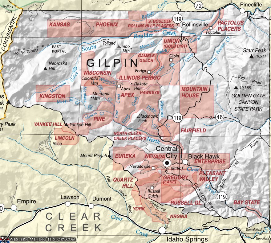
Gilpin is the second smallest county in Colorado, but has the second highest gold production. Several months after the big discovery on Clear Creek, gold was discovered by John Gregory near Blackhawk in 1859. A few months later, the placers and veins in Russell Gulch initiated a major rush into this mountainous area. Early lode mining was restricted to oxidized ore, which normally reached 40- to 100- feet below the surface. The construction of the Hill smelter in Blackhawk in 1868 enabled extraction of metals from the unoxidized sulfide ores. Later, the completion of the railroad from Denver to Blackhawk spurred production again. Mining diminished early in the 20th century and has proceeded only sporadically since 1909.
The first discoveries in the area occurred in Gamble Gulch in 1859 (Koschmann and Bergendahl, 1968). Stamp mills processed the oxidized ore and the level mining activity followed the same pattern as in Clear Creek County. Much placer activity occurred in the various gulches, especially near Rollinsville. The geology is much the same as in Clear Creek County, with Precambrian bedrock of the Idaho Springs Formation cut by Boulder Creek Granite with Tertiary intrusions of quartz monzonite and bostonite porphyries. Fissure fillings include pyritic gold that, where unweathered, is rather low grade but has been enhanced by oxidation.
Apex District
Vanderwilt (1947) consolidated the Apex District into the Pine-Kingston-Apex District. The Apex District is located within the Northern Gilpin District, which is a large area composed of a number of smaller mining districts that grew out of the 19th century gold boom. Made up of the significant gold- producing districts of Pine-Kingston-Apex and Perigo, the district also includes areas that have been called the Illinois, the Gamble Gulch, and the Union (or Gold Dirt), the Independent, the South Boulder Districts and the Rollinsville Placers. The Phoenix and the Kansas Districts are contiguous with the other North Gilpin districts and display the same geologic characteristics.
Dunn (2003) describes the Apex District as being located in the area of T2S R73W. Eberhart (1969) described the town of Apex (also known as Pine Creek) as being in the center of the Pine Creek District. Gold and silver production with some copper, lead and zinc is reported, with production up to 1945.
The geology is much the same as in Clear Creek County, with Precambrian bedrock of the Idaho Springs Formation cut by Boulder Creek Granite with Tertiary intrusions of quartz monzonite and bostonite porphyries. Fissure fillings include pyritic gold that where unweathered is rather low grade, but has been enhanced by oxidation. The most remarkable ore deposit in the district is in the Evergreen Mine near Apex, which was worked chiefly for copper (Vanderwilt, 1947). Chalcopyrite and bornite were the copper ore minerals and were found in and adjacent to monzonite porphyry dikes. The shipped ore averaged about 3% copper (Vanderwilt, Ibid).
The Apex Stock is the location of the Nye (or Nye-Mathews) molybdenum prospect. Additional references include Lovering and Goddard (1950) and Bastin and Hill (1917).
Bay State District
Minor lode gold producers include the Bay State District (consisting mainly of the Bay State Tunnel in the far southeast corner of Gilpin County), and the Hawkeye and Wisconsin Districts contiguous with the North Gilpin District. The geology of these districts is the same as those adjacent.
Records exist of the organization of the Bay State District on July 19, 1859 (Marshall, 1920), with the district delineated as occupying the area from the mouth of the North Fork of Clear Creek to the mouth of Russell Gulch, including the creek’s tributaries. The district appears in Henderson (1926), but little information is available.
Bay State District
The Central City and Idaho Springs Districts are geologically the northern end of a continuous belt of mineralization extending from the Rollinsville Placers to Idaho Springs on the south. It is commonly considered to contain the following smaller districts: Bay State, Central City, Enterprise, Eureka, Gregory, Nevada, Pleasant Valley, Quartz Hill, and Russell Gulch.
After the early discovery of gold in Clear Creek County, placer districts were developed in the Central City District in Nevada and Illinois Gulches. Lode deposits were shortly discovered but lasted only as long as the oxidized ore. Sulfide ores made accessible by the construction of the Blackhawk smelter in 1868, which treated unoxidized ores from all the nearby districts. Koschmann and Bergendahl quote a number of 4,200,000 ounces produced through 1959 in the district, including 30,000 ounces from placer deposits.
The geology was described by Moench, et al (1962) and Lovering and Goddard (1950). Precambrian gneisses and schists of the Idaho Springs Formation are injected with granodiorite also of Precambrian age. Later Tertiary porphyry intrusions of a range of compositions appear to have introduced the mineralization. Sims (1956) recognized four types of veins - pyrite-quartz; quartz-pyrite-chalcopyrite, tennanite (with some galena and sphalerite); pyritic lead-zinc veins of quartz, pyrite, galena, sphalerite with minor chalcopyrite and tennanite; and lead-zinc veins of quartz, galena, sphalerite, carbonate, and minor chalcopyrite, tennanite, and pyrite. Gold is present both in sulfides and as small native particles.
Enterprise District
Most of the historic mining areas in this small county are considered either part of the Central City or North Gilpin Districts by various reporters. The Enterprise District, lying east of the town of Blackhawk, is within the larger Central City District. It is separate from the Enterprise District in Boulder County listed by Henderson (1926). Claims for this district were being recorded by 1860 (Dunn, 2003).
Fairfield District
The Fairfield District is listed by Henderson (1926). It is described by Dunn (2003) as including the mouth of Missouri Gulch and the area around the North Fork of Clear Creek. The District was officially formed on May 28, 1860 and included, by a metes and bounds description, an area commencing at the Discovery claim and then running west, or up the reek one mile, and from the Discovery claim down the creek to the west line of Enterprise District or to the mouth of the Missouri Gulch, and to the summit of the mountains north and south (Marshall, 1920). Production included zinc, copper, lead, and gold (mindat.org).
Located in the Fairfield District were the Agra Mine (mindat.org) and a large placer operation in 1860 by the Boston Hydraulic Mining Corporation (Dunn, 2003).
Gamble Gulch District (included in Independent District)
The Gamble Gulch District is located within the North Gilpin District, which described in Bastin and Hill (1917), and Lovering and Goddard (1950) as a large area (approximately 35 square miles) stretching from North Clear Creek to the Boulder County line, east from Mammoth Gulch and Kingston Peak to the Eastern border of the Central City Quadrangle. The North Gilpin District is composed of a number of smaller mining districts that grew out of the 19th century gold boom. It is made up of the significant gold- producing districts of Pine-Kingston-Apex and Perigo, along with areas that have been called the Illinois, Gamble Gulch, Union (or Gold Dirt), South Boulder and the Rollinsville Placers. The Wisconsin, Phoenix and Kansas Districts are contiguous with the other North Gilpin districts and display the same geologic characteristics.
The first gold discoveries in the area occurred in Gamble Gulch in 1859 (Koschmann and Bergendahl, 1968). Stamp mills processed the oxidized ore and the level mining activity followed the same pattern as in Clear Creek County. Much placer activity occurred in the various gulches, especially near Rollinsville. The geology is much the same as in Clear Creek County, with Precambrian bedrock of the Idaho Springs Formation cut by Boulder Creek Granite with Tertiary intrusions of quartz monzonite and bostonite porphyries. Fissure fillings include pyritic gold that, where unweathered, is rather low grade, but has been enhanced by oxidation.
In the South Boulder Creek drainage, placer mining was carried out in Lump, Moon and Gamble Gulches. The latter was significant enough to warrant recognition as the Gamble Gulch District. Also at the north end of Gilpin County, the Pactolus and Rollinsville Placers are underlain by outwash gravels and according to Parker (1974), the most productive gravels were rather fine and lying on Precambrian bedrock. The principal placer area in Gamble Gulch was about 1.5 miles long and 500 feet wide at the widest point. The Rollinsville Placer was slightly larger (Parker, Ibid). Placer activity occurred in nearly all the gulches within the existing districts of Gilpin County. Additional references include: Eberhart (1969) and Henderson (1926).
This district contained the small settlement of Gilpin.
Gold Dirt District (aka Union District), part of Independent District
The Gold Dirt District is located within the North Gilpin District, described in Bastin and Hill (1917) and Lovering and Goddard (1950) as a large area (approximately 35 square miles) stretching from North Clear Creek to the Boulder County line, east from Mammoth Gulch and Kingston Peak to the Eastern border of the Central City Quadrangle. The North Gilpin District is composed of a number of smaller mining districts that grew out of the 19th century gold boom. It is made up of the significant gold- producing districts of Pine-Kingston-Apex and Perigo, along with areas that have been called the Illinois, Gamble Gulch, Union (or Gold Dirt), South Boulder and the Rollinsville Placers. The Wisconsin, Phoenix and Kansas Districts are contiguous with the other North Gilpin districts and display the same geologic characteristics. Henderson (1926) lists a Gold Dirt District in Clear Creek County, but he listed the Union District in Gilpin County.
The settlement of Gold Dirt was established in the winter of 1860-1861 by John Q. Rollins. Rollins erected a stamp mill for the local production and bought out most of the miners. The town was a mile down the gulch from the town of Perigo and actually produced more gold although the town was not as successful (Eberhart, 1969).
Bastin and Hill (1917) describe the Gold Dirt Mine as one of the first mines discovered in the area in 1860. The mine supported six mills at one point in its early years.
Gregory District (aka Lake District; aka Lake Gulch District; aka Gregory Diggings District)
The Gregory District is located within the Central City District, which is contiguous with, and so the same as, the Idaho Springs District in Clear Creek County. The basic geology includes interlayered Precambrian gneisses and schists, intruded by Precambrian granites of the Boulder Creek and Silver Plume family, with later Tertiary intrusions associated with mineralization.
John Gregory is credited with the first discovery in the area with the Gregory lode in Gregory Gulch between Blackhawk and Central city. Formation of the district involved the first mass meeting in Colorado according to Marshall (1920) when workers at the "Gregory Diggings" met on June 8, 1859. Among the speakers at that meeting was Hon. Horace Greeley. There were 2000 to 3000 miners present. As the meeting progressed, the participants outlined the district to include much of southeastern Gilpin County. The town of Mountain City was established near the site of the original Gregory discovery (Eberhart, 1969).
According to Dunn (2003), the definition of the Gregory District has evolved through time. At one time, it included what is now the entire Central City District. The district was shortly thereafter divided into smaller districts. The gold placer activity was mostly completed by 1863 although some activity continued after that (Parker, 1974).
The district produced gold and silver, with lesser copper, lead and zinc until 1945. Additional references include Bastin and Hill (1917) and Vanderwilt (1947).
Hawkeye District
The Hawkeye District is within the area defined as the North Gilpin District, which is a large area (approximately 35 square miles) described in Bastin and Hill (1917) and Lovering and Goddard (1950) as stretching from North Clear Creek to the Boulder County line, east from Mammoth Gulch and Kingston Peak to the Eastern border of the Central City Quadrangle.
The North Gilpin District is composed of a number of smaller mining districts that grew out of the 19th century gold boom. It is made up of the significant gold-producing districts of Pine-Kingston-Apex, Hawkeye and Perigo, along with areas that have been called the Illinois, Gamble Gulch, Union (or Gold Dirt), South Boulder and the Rollinsville Placers. The Wisconsin, Phoenix and Kansas Districts are contiguous with the other North Gilpin districts and display the same geologic characteristics.
A district called the Hawk Eye District was formed on July 31, 1860, which by the metes and bounds description places it south of the Central District (Marshall, 1920). The map in Marshall (1920) shows it bounded on the north by both the Independent District and the Central District, on the east by the Mountain House District, on the southwest by the Fairfield District and on the west by the Silver Lake District.
The Hawkeye District is listed in Henderson (1926), but is not found in mindat.org. An additional reference is Eberhart (1969).
Illinois District (aka Illinois Central District)
The Illinois District overlaps the Independent and Nevada Districts. Marshall (1920) lists the Illinois Central District being created on June 30, 1860 and shows it on a map in the area south of the Central City District, east of the Nevada District and north of the Russell District. Henderson (1926) lists the Illinois Central District (aka Illinois District) in Gilpin County. Generally a number of smaller districts in the southern part of Gilpin County are considered as part of the larger Central City District, including the Illinois or Illinois Central District.
Kansas District
The Kansas District was listed and located in Henderson (1926) and Dunn (2003). Marshall (1920) shows it on a map in the northwest corner of Gilpin County. Very little information is available on the District and its mines.
Kingston District
Vanderwilt (1947) consolidated the Kingston District into the Pine-Kingston-Apex District. The Kingston District is located within the Northern Gilpin District, which is a large area composed of a number of smaller mining districts that grew out of the 19th century gold boom. Made up of the significant gold-producing districts of Pine-Kingston-Apex and Perigo, the district also includes areas that have been called the Illinois, the Gamble Gulch, and the Union (or Gold Dirt), the Independent, the South Boulder Districts and the Rollinsville Placers. The Phoenix and the Kansas Districts are contiguous with the other North Gilpin districts and display the same geologic characteristics.
Lake District
Marshall (1920) shows that the Lake District was created on March 1, 1861 by uniting the Lake Gulch District with the Quincy District. A map provided in Marshall (1920) shows the district as being located just south of Gregory District. Refer to the Gregory District for a more detailed discussion.
Mountain House District
The Mountain House District is listed in Henderson (1926) and Dunn (2003). It is shown on a map in Marshall (1920) as being a large district in the northeast corner of the County. Not much is known about the District. Commodities included: zinc, silver, gold, cadmium, copper, and lead.
Nevada District
The Nevada District is now located within the larger Central City District. The Central City District is contiguous with, and so the same as, the Idaho Springs District in Clear Creek County. The basic geology includes interlayered Precambrian gneisses and schists, intruded by Precambrian granites of the Boulder Creek and Silver Plume family, with later Tertiary intrusions associated with mineralization.
The Nevada District, which was also called the New Nevada District, was one of the earliest districts organized in Gilpin County, with papers drawn up on September 28, 1860 (Marshall, 1920). The district was centered on Nevada Gulch, a tributary of North Clear Creek (Dunn, 2003).
The town of Nevada was formed several miles from Central City and named for the area in California. It was renamed Nevada City, but finally the name of the post office was changed to Nevadaville to avoid confusion with that other location (Eberhart, 1969). According to Eberhart (Ibid) the town flourished in the 1860s, again in the 1870s, nearly emptied during the "panic of 1883," but was rejuvenated in the 1890s, reaching a population of 1200 residents. The California Mine had the deepest shaft in the area - 2230 feet.
North Clear Creek Placers
The North Clear Creek placers were upstream from the town of Blackhawk. Parker (1974) notes particularly heavy activity at Pickle Gulch and Missouri Gulch and upstream from the mouths of these gulches. The district at some point overlaps with the Fairfield District to the north. The creeks and flood plains were worked by a variety of methods: surface bar mining, drifting, hydraulicking, dredging, and dragline operations. Originally they were dry operations and then hydraulicking by the 1900s to 1941 (Dunn, 2003). Lovering and Goddard (1950) comment that a dry-land dredge was operated in North Clear Creek near Blackhawk from 1937 to 1941 that was, for a time, the largest gold-producer in the county.
Northern Gilpin District
The Northern Gilpin District is a large area composed of a number of smaller mining districts that grew out of the 19th century gold boom. Made up of the significant gold-producing districts of Pine-Kingston-Apex, and Perigo, the area also includes areas that have been called the Illinois, the Gamble Gulch, and the Union (or Gold Dirt), the Independent, the South Boulder Districts and the Rollinsville Placers. The Phoenix and the Kansas Districts are contiguous with the other North Gilpin districts and display the same geologic characteristics.
Pactolus Placers
The Pactolus Placer District is located within the North Gilpin District, which is described in Bastin and Hill (1917) and Lovering and Goddard (1950) as a large area (approximately 35 square miles) stretching from North Clear Creek to the Boulder County line, east from Mammoth Gulch and Kingston Peak to the Eastern border of the Central City Quadrangle. The North Gilpin District is composed of a number of smaller mining districts that grew out of the 19th century gold boom. It is made up of the significant gold- producing districts of Pine-Kingston-Apex and Perigo, along with areas that have been called the Illinois, Gamble Gulch, Union (or Gold Dirt), South Boulder and the Rollinsville Placers. The Wisconsin, Phoenix and Kansas Districts are contiguous with the other North Gilpin districts and display the same geologic characteristics.
In the South Boulder Creek drainage, placer mining was carried out in Lump, Moon and Gamble Gulches. The latter was significant enough to warrant recognition as the Gamble Gulch District. Also at the north end of Gilpin County, the Pactolus and Rollinsville Placers are underlain by outwash gravels and, according to Parker (1974), the most productive gravels were rather fine and lying on Precambrian bedrock. The principal placer area in Gamble Gulch was about 1.5 miles long and 500 feet wide at the widest point. The Rollinsville Placer was slightly larger (Parker, Ibid). Placer activity occurred in nearly all the gulches within the existing districts of Gilpin County.
The Pactolus Placer District lay along South Boulder Creek from around the town of Pactolus to the Boulder County line. According to Parker (1974), one of the earliest placer discoveries in the state was made at the "Deadwood Diggings," near the mouth of Beaver Creek, which would be within the Pactolus Placer District. The deposits lie in outwash gravels, with an average depth of 16 feet. The gold was coarse, with nuggets up to a quarter ounce. Placer activity began in about the 1870s and lasted into the 1940s, but was intermittent in the 1930s (Dunn, 2003). Lovering and Goddard (1950) state that "a floating dredge recovered 7,796 ounces of gold from the Pactolus Placer on South Boulder Creek during 1937 to 1941" so the district was a prolific producer, averaging .0073 ounces per yard.
Pactolus and Rollinsville Placers
The "Deadwood diggings" near Pactolus were discovered in 1859 (Henderson, 1926, Spurr, et al, 1908) above the confluence of Beaver Creek with South Boulder Creek. The Pactolus area is south from Pactolus and the Rollinsville is upstream from Rollinsville. Outwash gravels carry gold, especially from the mouth of Moon Gulch to the Boulder County line. The gravels are medium to fine-grained (Parker, 1974). The gold is generally coarse, with nuggets up to 1/4 ounce found near Pactolus.
Lovering and Goddard (1950) state that "a floating dredge recovered 7,796 ounces of gold from the Pactolus Placer on South Boulder Creek during 1937 to 1941" so the district was a prolific producer, averaging .0073 ounces per yard.
The Rollinsville placer district is nearly 2 miles long and up to 650 feet wide at its widest. The best values have been found in fine-grained gravel immediately overlying bedrock.
Presumably the source of the gold is the rather low-grade veins that criss-cross the gulches upstream of the placers.
Perigo District (aka Independent District aka Independence District)
The Perigo District is located within the North Gilpin District, which is described in Bastin and Hill (1917) and Lovering and Goddard (1950) as a large area (approximately 35 square miles) stretching from North Clear Creek to the Boulder County line, east from Mammoth Gulch and Kingston Peak to the Eastern border of the Central City Quadrangle. The North Gilpin District is composed of a number of smaller mining districts that grew out of the 19th century gold boom. It is made up of the significant gold- producing districts of Pine-Kingston-Apex and Perigo, along with areas that have been called the Illinois, Gamble Gulch, Union (or Gold Dirt), South Boulder and the Rollinsville Placers. The Wisconsin, Phoenix and Kansas Districts are contiguous with the other North Gilpin districts and display the same geologic characteristics.
Using the Perigo and Smuggler Mines as an example, the district was characterized by multiple heavily mineralized east to northeast-trending veins. Commodities produced were lead, zinc, copper, silver (Lovering and Goddard, Ibid). Production was reported until 1945.
The Independent District was created on May 19, 1860 (Marshall, 1920). It was surrounded by the Union, Central, Hawk Eye, Silver Lake and Pine Districts, as shown on a map in Marshall (1920). The town of Perigo which was settled in about 1860 by prospectors at Gamble Gulch (Dunn, 2003) and was a thriving place, boasting a 30-stamp mill and an opera.
Additional references are Eberhart (1969), Henderson (1926) and Vanderwilt (1947).
Phoenix District
Henderson (1926) describes the Phoenix District as overlapping with the Pine District included in the larger North Gilpin District. The Pine District is discussed by Dunn (2003). The North Gilpin District is described in Bastin and Hill (1917) and Lovering and Goddard (1950) as a large area (approximately 35 square miles) stretching from North Clear Creek to the Boulder County line, east from Mammoth Gulch and Kingston Peak to the Eastern border of the Central City Quadrangle. The North Gilpin District is composed of a number of smaller mining districts that grew out of the 19th century gold boom. It is made up of the significant gold-producing districts of Pine-Kingston-Apex and Perigo, along with areas that have been called the Illinois, Gamble Gulch, Union (or Gold Dirt), South Boulder and the Rollinsville Placers. The Wisconsin, Phoenix and Kansas Districts are contiguous with the other North Gilpin districts and display the same geologic characteristics.
Pine District
Vanderwilt (1947) consolidated the Pine District into the Pine-Kingston-Apex District. The Pine District is located within the Northern Gilpin District, which is a large area composed of a number of smaller mining districts that grew out of the 19th century gold boom. Made up of the significant gold- producing districts of Pine-Kingston-Apex and Perigo, the district also includes areas that have been called the Illinois, the Gamble Gulch, and the Union (or Gold Dirt), the Independent, the South Boulder Districts and the Rollinsville Placers. The Phoenix and the Kansas Districts are contiguous with the other North Gilpin districts and display the same geologic characteristics.
The Pine District is also referred to as the Pine Creek District. It may refer to an indistinctly defined area around Pine Creek, a tributary of North Clear Creek (Dunn, 2003). The small mining camps of Twelve Mile, Pine Creek and Elk Park near Apex are considered to be within this district according to Eberhart (1969).
Pleasant Valley District
The Pleasant Valley District was one of the earliest districts in the state, formed on September 3, 1859 (Marshall, 1920). Although it is shown on the map in Marshall (1920) as Pleasant Valley District, the text section refers to it as Pleasant Valley No. 10 District. It is commonly considered a part of the larger Central City District. The Central City District is contiguous with, and so the same as, the Idaho Springs District in Clear Creek County. Henderson (1926) does not list a Pleasant Valley District in Gilpin County, only one in Fremont County. According to Dunn (2003), the district overlaps with the Russell Gulch and Lake (Gregory) Districts. There is very little information on this early-formed district.
Rollinsville Placers
The Rollinsville Placers District is located within the North Gilpin District. The North Gilpin District was described by Bastin and Hill (1917) and Lovering and Goddard (1950) as a large area (approximately 35 square miles) stretching from North Clear Creek to the Boulder County line, east from Mammoth Gulch and Kingston Peak to the Eastern border of the Central City Quadrangle. It is composed of a number of smaller mining districts that grew out of the 19th century gold boom. Made up of the significant gold-producing districts of Pine-Kingston-Apex and Perigo, the district also includes areas that have been called the Illinois, the Gamble Gulch, and the Union (or Gold Dirt), the Independent, the South Boulder Districts and the Rollinsville Placers. The Phoenix and the Kansas Districts are contiguous with the other North Gilpin districts and display the same geologic characteristics.
In the South Boulder Creek drainage, placer mining was carried out in Lump, Moon and Gamble Gulches. The latter was significant enough to warrant recognition as the Gamble Gulch District. Also at the north end of Gilpin County, the Pactolus and Rollinsville Placers are underlain by outwash gravels and, according to Parker (1974), the most productive gravels were rather fine and lying on Precambrian bedrock. Dunn (2003) indicates that the source of the Rollinsville Placer was the nearby Gamble and Moon Gulches. The principal placer area in Gamble Gulch was about 1.5 miles long and 500 feet wide at the widest point. The Rollinsville Placer was slightly larger (Parker, Ibid). Placer activity occurred in nearly all the gulches within the existing districts of Gilpin County.
The Rollinsville District lies along South Boulder Creek upstream of the town of Rollinsville. Parker (1974) places the district upstream from Rollinsville to the mouth of Moon Gulch - 1 3/4 miles long and 650 feet wide at its widest. Presumably the source of the gold is the rather low-grade veins that criss-cross the gulches upstream of the placers.
Mindat.org includes the Manchester Mine in the Rollinsville District. This mine is characterized by ferberite - a tungsten ore, and so the Rollinsville District would be considered to be the southern end of the Boulder Tungsten District - obviously a lode mine rather than placer.
Gregory and Russell Gulches
Placers in Gregory and Russell Gulches were among the earliest in Colorado. Little has been done in these areas since the 1880s. The placers occur on the typical Gilpin County bedrock of gneisses and schists of the Precambrian Idaho Springs Formation. The area is characterized by veins containing gold as both small, native particles or in sulfides. Oxidation of these veins produced abundant free gold on the surface.
In general, three types of deposits characterize the districts - alluvial placers on the valley floor, colluvial placers (mined by drifting), and outcrops of oxidized bedrock that could be worked by sluicing (Parker, 1974). Parker comments that there are probably remaining colluvial "drift sheets" that could be profitably recovered by small-scale hand working.
Russell Gulch District (or Russell District)
The Russell Gulch District is located within the Central City District, which is contiguous with, and so the same as, the Idaho Springs District in Clear Creek County. The basic geology includes interlayered Precambrian gneisses and schists, intruded by Precambrian granites of the Boulder Creek and Silver Plume family, with later Tertiary intrusions associated with mineralization.
William Green Russell made a discovery in the spring of 1859 in present-day Russell Gulch and the Russell District was officially formed on June 18th of that year (Marshall, 1920). According to Eberhart (1969), some of the first mining laws in the state were drawn up here. By the next spring, Russell Gulch had over 2,500 residents. The Consolidated Ditch was built in 1860 to bring water from the Fall River to Russell Gulch and other nearby gulches for placer operations (Dunn, 2003). Russell Gulch was the site of much bootlegging activity during prohibition, as bootleggers used the old mines to hide their products.
Placers were important early in Russell Gulch, but petered out and were operated on sporadically after the turn of the century. In general, there are three types of placer deposits - alluvial placers on the valley floor, colluvial placers (mined by drifting), and outcrops of oxidized bedrock that could be worked by sluicing (Parker, 1974).
Commodities in the district included gold, silver, copper, lead, and zinc (Dunn, 2003).
South Boulder Creek Placers
The South Boulder Creek Placer District is located within the North Gilpin District. The North Gilpin District is described in Bastin and Hill (1917) and Lovering and Goddard (1950) as a large area (approximately 35 square miles) stretching from North Clear Creek to the Boulder County line, east from Mammoth Gulch and Kingston Peak to the Eastern border of the Central City Quadrangle. It is composed of a number of smaller mining districts that grew out of the 19th century gold boom. Made up of the significant gold-producing districts of Pine-Kingston-Apex and Perigo, along with areas that have been called the Illinois, Gamble Gulch, Union (or Gold Dirt), South Boulder and the Rollinsville Placers. The Wisconsin, Phoenix and Kansas Districts are contiguous with the other North Gilpin districts and display the same geologic characteristics.
The South Boulder Creek Placer district is often considered to include both the Rollinsville District and the Pactolus District (Dunn, 2003). Marshall (1920) indicates that although it existed in August 1860, the district was legally created on March 30, 1861. Dunn, 2003 indicated that the district was located at the border with Boulder County along South Boulder Creek (from the mouth of Moon Gulch through Rollinsville and Pactolus North to the County border). An additional reference is Parker (1974),
Wisconsin District
The Wisconsin District is located within the North Gilpin District, which is a large area composed of a number of smaller mining districts that grew out of the 19th century gold boom. Made up of the significant gold-producing districts of Pine-Kingston-Apex and Perigo, the district also includes areas that have been called the Illinois, the Gamble Gulch, and the Union (or Gold Dirt), the Independent, the South Boulder Districts and the Rollinsville Placers. The Phoenix and the Kansas Districts are contiguous with the other North Gilpin districts and display the same geologic characteristics.
Henderson (1926) and Dunn (2003) showed it as being located at Sections 1-5, 8-17, and 21-25, inclusive, T2S R74W; Sections 7, 18-19 T2S R73W. Marshall (1920) shows in on a map abutting Summit County and being bounded by the Kansas District to the north, Phoenix and Pine Districts to the east, and Vermilion District to the south. The district was formed on February 13, 1860 and the White Quail District became part of the District on May 19, 1860 (Marshall, 1920). Little information is available about the district.
Yankee Hill District
The Yankee Hill District is also in Clear Creek County. Refer there to the Alice-Yankee Hill District.