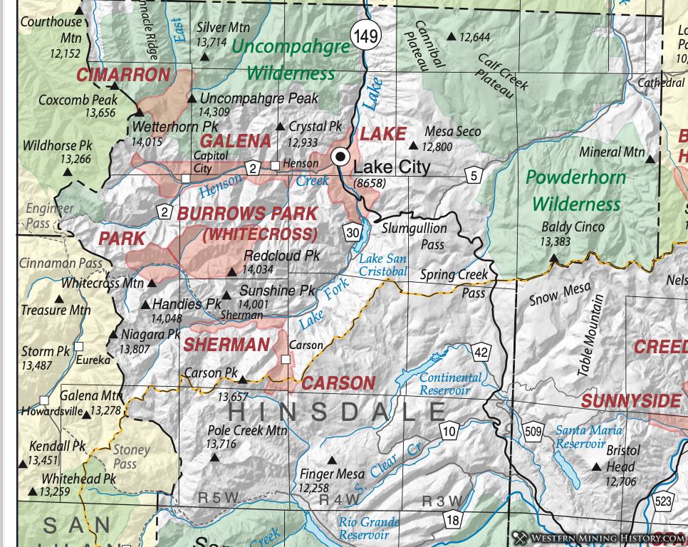
Burrows Park District (aka Whitecross District; aka Park District)
This district is possibly an amalgamation of several districts, but at least has several names. Henderson provides very a very specific location for the Park District, listing 16 sections in three different townships that appear to be the same as other descriptions of the Whitecross/Burrows Park District. Dunn (2003) indicates that the Burrows Park District may have originally been known as the Park District, which seems to fit with Henderson's description. She notes that Hinsdale County was divided into six districts by the state legislature in 1893, of which the Park District was one, along with the Carson, Cimarron, Galena, Lake, and Sherman Districts. Mindat.org (Sep 2015) considers the Burrows Park, the Park and the Whitecross to be the same district, a convention we follow here.
Vanderwilt (1947) considered the Burrows Park District, which he described as sitting at the head of the Lake Fork of the Gunnison River, to be a continuation of the mineralization of the Silverton area. Wilson and Spanski (2004) aggregated the Burrows Park District in with eight other districts as the "San Juan Mineralized Area." The connection is that they appear to lie within the San Juan caldera of Steven and Lipman (1976). (The other districts in this grouping are the Galena/Henson Creek, the Sneffels, South Ouray, Eureka, Telluride, Ophir, Red Mountain and Lower San Miguel, of which the Galena is in Hinsdale County.)
The geology consists of tuffs and flows associated with the Oligocene San Juan caldera complex, with an outlier of Precambrian granites in the middle (Vanderwilt, 1947). Mineralization consists of "filled fissures grading into replacement types" of chalcopyrite ore, sphalerite-galena ore or gold-silver ore with small amounts of lead and zinc (Vanderwilt, Ibid).
Eberhart (1969) discusses the three settlements that arose around Cinnamon Pass - Whitecross, Tellurium and Sterling. He indicates that the harsh winters and associated transportation problems inhibited both the mines and the towns.
Carson District
There are not many districts in Hinsdale County, but there are numerous names and potential confusion. The Carson District appears in Henderson (1926) and is described by Vanderwilt (1947 as sitting at the head of Wager Gulch (a tributary of the Lake Fork of the Gunnison River), approximately 18 miles southwest of Lake City. The area of the district crosses the continental divide into the headwaters of Lost Trail Creek.
Older geologic descriptions of the area can be found in Irving and Bancroft (1911). Based on more recent interpretations, Wilson and Spanski (2004) describe the area as the Carson volcanic center, a 29 Ma plug of monzonite to quartz monzonite composition, intruding intermediate lavas and breccias, and andesites and rhyolites of the Henson and Burns formations.
The rocks contain polymetallic veins in irregular fissures and fractures up to 18 inches wide (Larson, 1911). Ores contain silver and lead with some copper. Enargite, chalcopyrite and galena occur with some gold in a barite gangue. Some bog iron is also known to occur (Harrer and Tesch, 1959).
Eberhart (Ibid) describes the mining camp of Carson, established in 1882, the year after the district. The town sat directly on the continental divide, with water falling on one side of town heading toward the Lake Fork of the Pacific drainage, and water on the other side of town flowing into the Lost Trail Creek, of the Rio Grande system, headed toward the Atlantic Basin. With such a snow-bound location, the town didn't last long.
Cimarron District
The Cimarron District was one of the six districts into which the Colorado legislature divided Hinsdale County in 1893. (The others were the Galena, Sherman, Lake, Whitecross and Carson Districts.) The Cimarron is a small district with little development occupying the far northwestern corner of Hinsdale County. It includes areas from the Ouray County line at Wetterhorn Peak east to Uncompahgre Peak (Luedke, 1972). It was identified by Henderson (1926). Dunn (2003) also mentions the district, and assigned the Silver Jack and Conkling Lode to it. Mindat.org adds the Golden Eagle and Government Stamp lodes.
Wilson and Spanski (2004) have some information on the areas. The geology shows some small intrusions of 30 to 35 Ma age of monzonite to quartz monzonite (Lipman et al., 1976). The only verified production came from the Silver Jack Mine, which produced small amounts of silver and lead ore. There are some 240 unpatented claims (the Dix and Cimarron Chief claims) on molybdenum prospects on the south edge of the Matterhorn Peak stock.
Galena District (aka Henson Creek District)
The Galena District was one of the six districts into which the Colorado legislature divided Hinsdale County in 1893. (The others were the Carson, Cimarron, Lake, Whitecross and Sherman Districts.) The district occupies the Lake City, Uncompahgre Peak and Redcloud Peak quadrangles.
Henderson (1926) recognized the Galena District in his compilation for Colorado, and Vanderwilt (1947) placed it along Henson Creek, west of Lake City and considered the Henson Creek District an alternate name. He noted that all the productive mines were located near the creek.
The Galena District overlaps (or blends into) the major district to the east, known variously as the Lake, Lake City, and/or Lake Fork District. Mindat.org separates these into two districts. The seminal work on the area - Irving and Bancroft (1911) does not distinguish the different districts, but rather discusses mines in the vicinity of Lake City.
Further confusing the situation, the Galena/Henson Creek District is described by the name of the creek. Irving and Bancroft list the group of mines among the most famous and productive in the area (the Hidden Treasure, Ute and Ulay) among the "Henson Creek Mines" which implies Henson Creek (Galena) District; mindat.org lists these in the Lake City District, as does Dunn (Ibid). Vanderwilt (Ibid) places these mines in the Galena (Henson Creek) District also, and provides a structural distinction between the two districts, noting that a down-faulted block lies between Henson Creek and Lake Fork. We have chosen to make the distinction as mindat.org does, so that referencing the mines will be easier for the reader.
The geology and mineralization of the district is typical of the western San Juan Mountains. The district sits within the caldera fill on the northeast margin of the Lake City Caldera (Steven and Lipman, 1976; Wilson and Spanski, 2004). Units include Oligocene quartz latite and andesitic flows and breccias of significant lateral extent, plus more localized flows; the Bachelor Mountain and Carpenter Ridge tuffs, the Fish Canyon tuff, the La Garita tuff, the Henson and Burns formations, the Sapinero Mesa, Eureka and Dillion Mesa tuffs along with silicic lavas (Day et al., 1999). Generalized descriptions are also available in Sanford et al. (1987).
Mineralization was described generally by Vanderwilt (Ibid) as vein mineralization continuous with that of the Silverton area. Bove et al. (2000) distinguish 23 Ma precious metal-bearing barite veins and older base-metal veins. Irving (1905) and Irving and Bancroft (1911) provide a detailed descriptions of the rocks and mineralization.
The town of Henson was the main settlement in the district. It was the site of a major miners strike in 1899 centered on the Ute-Ulay and Hidden Treasure Mines (mines which we have placed in the Lake City District, further demonstrating the overlapping of the districts in this area). The Colorado governor sent six companies of troops to keep order and the strike was finally settled with the involvement of the Italian consul. (Eberhart, 1969).
Lake City District (aka Lake District; aka Lake Fork District)
The Lake City District has been identified as the Lake, the Lake City and the Lake Fork District. These districts are occasionally differentiated, but here we include all as the same district, extending south to Lake San Cristobal.
The Lake District was one of the six districts into which the Colorado legislature divided Hinsdale County in 1893. (The others were the Carson, Cimarron, Galena, Whitecross and Sherman Districts.) The district occupies the Lake City, Uncompahgre Peak and Redcloud Peak quadrangles.
Lake overlaps (or blends into) the major district to the west, the Galena or Henson Creek District. Mindat.org separates the Lake and the Galena into two districts. The seminal work on the area - Irving and Bancroft (1911) does not distinguish the different districts, but rather discusses mines in the vicinity of Lake City.
Mindat.org and Dunn (2003) list the group of mines (the Hidden Treasure, Ute and Ulay) among the most famous and productive in the Lake City District. However, Irving and Bancroft (Ibid) lists them among the "Henson Creek Mines," which implies Henson Creek (Galena) District. Vanderwilt (1947) places these mines in the Galena (Henson Creek) District also, and provides a structural distinction between the two districts, noting that a down-faulted block lies between Henson Creek and Lake Fork. We have chosen to make the distinction as mindat.org does to make referencing the mines easier for the reader.
Irving and Bancroft (Ibid) distinguish a group of mines as the San Cristobal Group, south of Lake City - a geographic distinction that we believe places those mines in the Lake City district.
The geology of the Lake City District is typical of the San Juan Mountains. The district sits within the caldera fill on the northeast margin of the Lake City Caldera (Steven and Lipman, 1976; Wilson and Spanski, 2004). Units include Oligocene quartz latite and andesitic flows and breccias of significant lateral extent, plus more localized flows; the Bachelor Mountain and Carpenter Ridge tuffs, the Fish Canyon tuff, the La Garita tuff, the Henson and Burns formations, the Sapinero Mesa, Eureka and Dillion Mesa tuffs along with silicic lavas (Day et al., 1999). Generalized descriptions are also available in Sanford et al. (1987).
Mineralization was described generally by Vanderwilt (Ibid) as vein mineralization continuous with that of the Silverton area. Bove et al. (2000) distinguish 23 Ma precious metal-bearing barite veins and older base-metal veins. Irving (1905) and Irving and Bancroft (1911) provide a detailed descriptions of the rocks and mineralization.
Some top-producing mines include the Golden Fleece (nee Hotchkiss) mine, discovered in 1874, which produced $1.4M in metals (Henderson, 1926). The Pelican Mine produced off and on from 1891 to 1960; Irving and Bancroft (Ibid) report freibergite, pyrargyrite and galena as the main minerals. The Fanny Fern Mine produced silver from tetrahedrite, reporting 74,000 ounces of silver and 65 ounces of gold. The Black Crook Mine operated off and on until 1953. The Contention Mine was another major producer.
The Ute and Ulay veins are names that always appear in relation to the mines and deposits of the Lake City area. The Ute was the most productive and important of all the mineral veins in the district (Irving and Bancroft, Ibid). The vein was traced for 2,700 feet along outcrop. The vein described an arc, concave to the northwest, averaging four feet in width, but pinching and swelling and occasionally splitting. The vein sequentially filled first with quartz, then rhodochrosite/tetrahedrite/galena and then more quartz.
Later movement shattered the vein material and deposited more quartz and barite. The ore mineralization was (presumably, because it was mostly gone even before Irving and Bancroft visited) argentiferous galena with subsidiary tetrahedrite, sphalerite, pyrite and enrichments of ruby silver (proustite/pyrargyrite - Ag3AsS3- Ag3SbS3). Further details are available in Irving and Bancroft (Ibid).
A unique situation has been identified at the Golden Wonder Mine. Irving and Bancroft (Ibid) recognized it as the "only true replacement deposit" in the Lake City area. It was recognized as a hot spring deposit in the 1980’s (Billings, 1983; Billings and Kallowkoski, 1982; Kalliokoski and Rehn, 1987), described as a small epithermal alunitic gold and base metal deposit within flow-foliated rhyolite. The deposit contains considerable gold (often microscopic native gold) and maintains an active permit with the State of Colorado as of 2015 for LKA Gold Incorporated.
Early activity did not develop until the Brunot Treaty of 1873 with the Ute tribe allowed worry-free entry into the territory. The Ute-Ulay discovery had been made in 1871, but not developed until the treaty was in place (Eberhart, 1969). Lake City was the first settlement, named for Lake San Cristobal. Many colorful characters passed through the town, including Alfred Packer, the famous Colorado cannibal.
Sherman District (aka Park District)
The Sherman District was one of the six districts into which the Colorado legislature divided Hinsdale County in 1893. (The others were the Galena, Cimarron, Lake, Whitecross and Carson Districts.) The location of the Sherman District is not well defined. Henderson (1926) indicates that the Park District overlaps the Sherman District. He provided a specific location for the Park District that appears to include the area we have enclosed in the Burrows Park District. He does indicate that it overlaps the Sherman District. Dunn (2003) distinguishes the two districts, with the Park District on the Lake Fork of the Gunnison River and the Sherman in the vicinity of the ghost town of Sherman. Mindat.org calls the two districts the same and places both south of the Cinnamon Pass area, which we have placed in the Burrows Park District. In general, we place the Sherman District (aka Park District) south of Handies Peak, to the area around Cottonwood Creek.
Dunn (Ibid) assigns the Black Wonder, Washington and Vermont mines to the Sherman District and the Illinois Boy, Champion and Grand Republic to the Park District. We have placed the Illinois Boy and Champion in the Burrows Park District.
The geology is generally described in Lipman (1976) and Lipman et al. (1976), summarized in Sanford et al. (1987) as lying in the area of the San Juan and Lake City calderas. Rocks included are Sapinero Mesa tuff and megabreccia, Precambrian granite representing the terrain in which the calderas formed, along with post-breccia lava flows and fill.
Mineralization is similar to the other Hinsdale County districts, with predominately veins carrying gold and silver, and some base metals. Sanford et al. (Ibid) found potential for precious and base metals, and porphyry molybdenum.