Embargo District
(Refer to Saguache County)
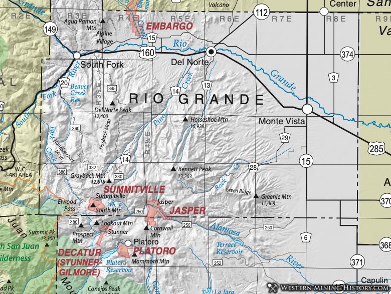
Jasper District (aka Decatur Northeast District)
The prospects and mines are about one-half mile west of Jasper generally in the vicinity of the Animas River and its tributaries. The general geology is the same as the Platoro (aka Lake Fork) District and the Stunner (aka Decatur) District (Vanderwilt, 1947). The district did not produce significant amounts of gold or silver.
The geology of the area is predominately igneous in origin. This district lies in the eastern part of the San Juan volcanic field and the late Oligocene-aged Platoro and nested Summitville calderas constitute a composite collapse structure of about 20 kilometers in diameter (Steven & Lipman, 1976). Ore was found in mineralized epithermal quartz-latite veins that extended over long distances. Gold, silver-lead and lead-zinc ores are reported (Dunn, 2003).
The town of Jasper died before it learned that the ore sent to Denver was good, because the smelter in Denver burned before the 10 tons of ore sent there in 1887 could be assayed (Eberhart, 1969). The town of Jasper was originally called Cornwall for John Cornwall, the first postmaster (Eberhart, Ibid). The site is now a haven for fisherman and tourists.
Summitville District (aka Summit District)
The Summitville District, which went by an earlier name of Summit District, was being worked beginning in the 1870’s, and was the first district in the area (Patton, 1917). Its location is at the north foot of South Mountain nearly at the head of Wightman's Fork, a branch of the Alamosa River. The elevation of the town is approximately 11,300 feet.
Henderson (1926) included the Decatur District in Conejos County into the Summit District. Here we have separated the Summit (Summitville) District due to being located in a separate county and having ores of different genesis and age (Steven and Ratte, 1960).
The geology of the area is igneous in origin. This district lies in the eastern part of the San Juan volcanic field and the late Oligocene-aged Platoro and nested Summitville calderas constitute a composite collapse structure of about 20 kilometers in diameter (Lipman, 1974; Steven & Lipman, 1976). The Summitville Au–Ag–Cu deposit is a classic volcanic dome-hosted high-sulfidation deposit. It occurs in the Quartz Latite of South Mountain, a composite volcanic dome that was emplaced along the coincident margins of the Platoro and Summitville calderas at 22.5±0.5 Ma, penecontemporaneous with alteration and mineralization. A penecontemporaneous quartz monzonite porphyry intrusion underlies the district and is cut and overlain by pyrite–quartz stockwork veins with traces of chalcopyrite and molybdenite (Bethke et al., 2005). The mines of this district are located on a series of parallel running veins that have a general northwest and southeast strike (Patton, 1917).
Stoffregen (1987), Gray et al. (1993), and Gray and Coolbaugh (1994) provided detailed descriptions of the geology and mineralization of the Summitville mine site. The Summitville Mine has been the focus of attention because of environmental problems resulting from open-pit mining activities that occurred from 1984 to 1992. The environmental problems included leakage of cyanide solutions from a heap leach pad and drainage of acid- and metal-rich waters into the Wightman Fork of the Alamosa River, which drains into agricultural lands of the southwest San Luis Valley (Flohr et al., 1995). Multiple USGS environmentally-related studies have been performed, which are not discussed here.
Discussions of other mines in the district are included in Patton (1917). In 1883 there were nine stamp mills with a total of 155 stamps. The San Juan, Odin, Little Annie and Golconda mines had gravitation tramways for transporting the ore from mines to mills. The Iowa and Colorado Company had a wire tramway of the Halliday patent for like purposes.
Gold placering was also performed from 1870 to about 1880 and yielded considerable gold, the largest being a 1-inch nugget (Patton, 1917). Placer claims in the district included the Peterson, Brant, and San Juan (Patton, 1917).
Summitville was the largest and richest camp in the 1880’s with a population as large as 600, and besides the nine mills had 14 saloons and a newspaper, The Summitville Nugget. Summitville began fading in the late 1880s, and was deserted by 1893. It was revived and grew to a population of 700 when the mines reopened in 1935 under Consolidated Mines Inc. It produced much copper during World War II (Eberhart, 1960).