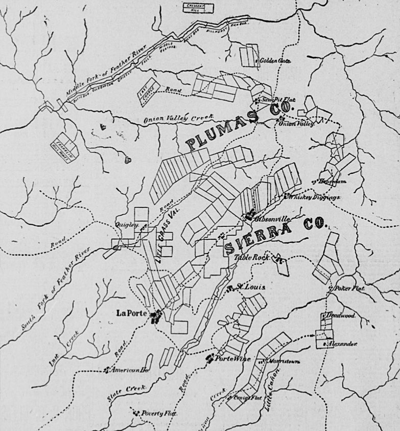
The following article describing the early history of Plumas County gold districts and a resurgence of mining in the mid-1890s appeared in the San Francisco Call on July 18, 1895. The map image was published with the article, all other images were added from separate archives.
Plumas is county of rugged mountains, holding in their mighty embrace many green and fertile valleys. Lofty snowcapped peaks and sloping hills, rich in their robes of green, greet the eye on every I hand, while winding through a maze of scenic beauty almost unparalleled in the bold strokes of nature are hundreds of clear mountain brooks singing in joy or roaring in precipitous descent as they rush onward to unite their waters with the great streams that carry them into the valleys and thence into the bosom of the mighty ocean.
These great divisions of the Feather River, one of the principal confluents of the Sacramento — the middle fork, the north and east branches of the north fork — have their source in this county, and from thousands of tributaries receive the mighty flow of water that falls as rain or snow on the lofty hills or secluded valleys, having ramifications in every nook and corner of this wide and wild expanse.
High up among the white-robed peaks are hundreds of pellucid lakes and lovely mountain tarns, reposing sweetly in their isolated abode far from the busy scenes of life below.
Born of the glaciers, they carry the mind back to those far distant ages in the history of our planet when great fields of ice furrowed their way through mighty mountains, flowing in their irresistible advance through the deep canyons and ravines that form our water-courses, tilling the valleys with an alluvial deposit which has yielded rich rewards to the husbandman, laying bare those vast storehouses of gold that for over a third of a century have replenished the world’s wealth, and finally, as they disappeared, with fury spent, fashioning with icy hands a multitude of little lakes far up among the loftiest peaks of the Sierra.
Plumas County lies wholly on the western slope of the mountains, and scarcely a drop of water falls within its limits that does not find a way into one of the many tributaries of the Feather, and thence to the sea.
The watershed between the Nevada and Sacramento basins forms the dividing line between Plumas and Lassen, while the dividing ridge between the Feather and the Yuba forms the Sierra County line. On the northwest, the dividing ridge between the waters of the Feather and of Butte and Deer creeks forms the county line, so that Plumas County lies wholly within the domain of the Feather River. Its greatest length is from northwest and southeast, or from Lassens Peak to Beckwith Pass, a distance of eighty-five miles.
Transversely, from southwest to northeast, it is but forty-five miles. The whole embraces an area of over 2000 square miles, or 1,280,000 acres. Of this some 200,000 acres are agricultural land, distributed among a number of fertile valleys. Chief among these may be mentioned the American, Indian, Big Meadow, Mohawk, Sierra, Bucks, Onion and Last Chance.
The greatest portion, however, is made up of mountains covered with a heavy growth of coniferous trees— sugar and yellow pine, spruce, balsam fir and cedar, while mountain oak, manzanita, laurel, buckeye, alder and chaparral grow in great profusion. In supplying timber for flumes, mines and general improvements, these great forests have been invaluable, and the territory is now denuded of its growth of pine, spruce and cedar tells the extent to which this kindly provision of nature has been utilized by the husbandman and miner alike sincsne the first white man penetrated the region.
Pilot Peak, which stands near the southern line of the county, is a volcanic knob of basaltic rock most beautifully columnar on its northern slope, and from the summit of which a fine view may be obtained of the surrounding country, Lassens Peak being visible in the northwest and the Coast Ranges in the southwest. Off to the west lies Table Mountain, nearly as high as the great peak, which has an elevation of something over 7000 feet above the level of the sea.
Quincy is the chief town and county seat. It is situated in a great basin called the American Valley, which is eleven miles long and three miles wide, having an elevation of about 3500 feet.
A few miles from Quincy on the road to Indian Valley is the old mining town of Elizabethtown, for many years a fierce rival of the American Valley settlement for county honors. In 1852 Alex and Frank Tate discovered gold in a ravine near the town, and soon afterward Lewis Stark, Peter Day and George Ferrier, who arrived through Beckwith Pass with their families, went to work near the Tate claim.
For a week they prospected without success and then moved up the Elizabeth ravine, where one day’s work yielded four ounces. Two days after Stark picked up a nugget weighing twenty-seven ounces, and soon the fame of the location got abroad and called other prospectors, who in due time built up a town.
Stark built the first house, and the town was named in honor of his only daughter, Elizabeth, who now resides at Quincy. Elizabethtown made the most strenuous efforts to become the county seat when Plumas was organized, but Quincy won the prize.
In 1855 she also took the post office from the rival metropolis, and soon after Elizabethtown went into a decline from which she never recovered, dying a natural and easy death, with her boots off, after a useful and happy life. Quincy is surrounded by a fine agricultural country, and the mineral possibilities of the adjacent mountain region are said to be good.
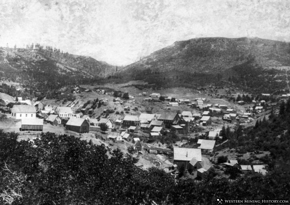
Next in importance comes La Porte, the center and natural outlet of a section of half-developed mining country that is just now feeling the effects of a long-expected boom. That La Porte is destined to become in the near future the most important town in Plumas County no one can for a moment doubt, when her natural advantages are considered.
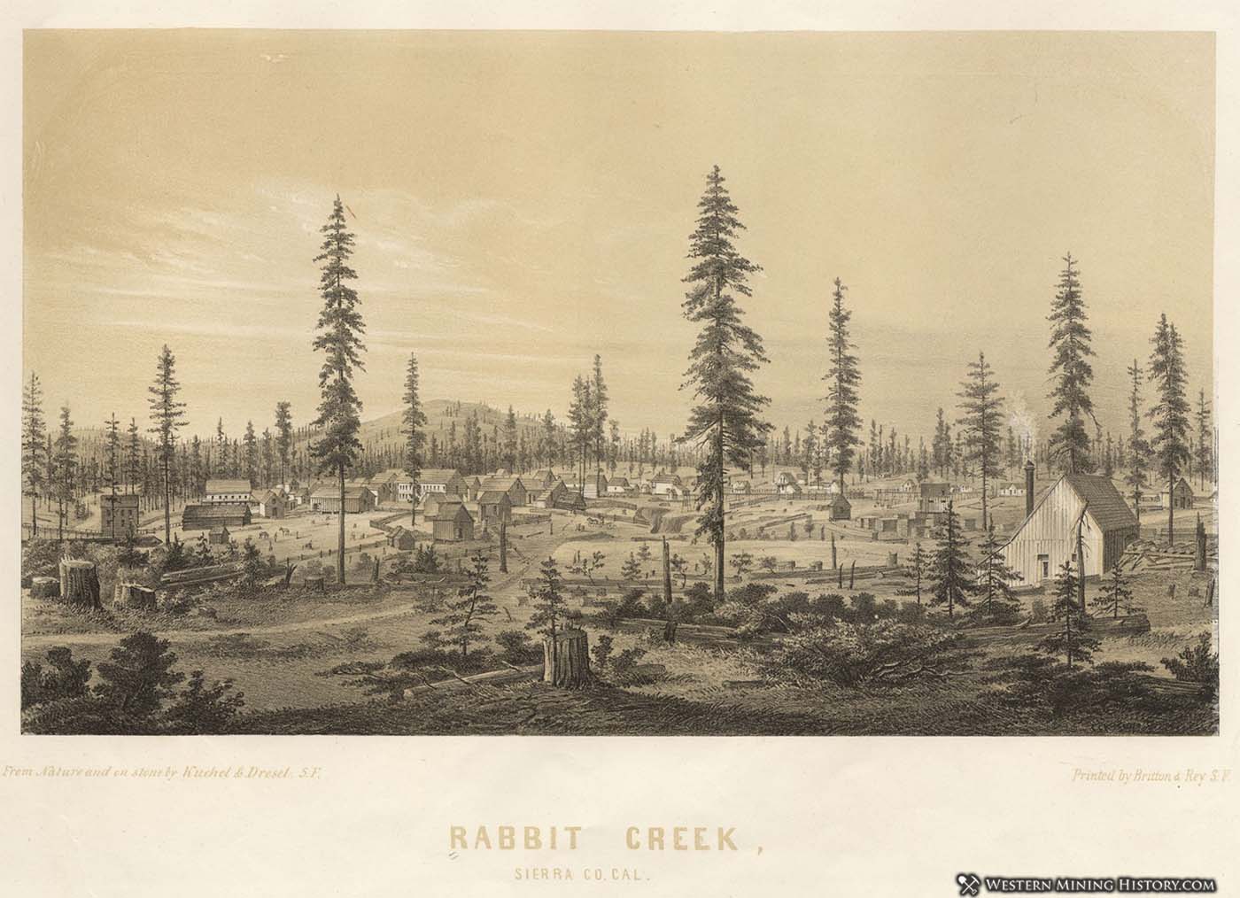
The town is situated in the southeastern part of Plumas, near the Sierra county line, and was formerly a part of this latter division. It is pleasantly located on Rabbit Creek, at an elevation of 4500 feet above the sea, and has stage connection with Oroville and Marysville, the junction of the two lines being at Woodville.
Downieville is twenty miles away and the county seat is reached over a finely graded road of thirty-five miles built at an expense of $30,000, and traversing a region of rare scenic beauty and rich in mineral resources. The town is shut in by mountains, out of which rises in towering majesty Bald Peak to a height of 1000 feet above the surrounding country, affording an unobstructed view of hundreds of miles in every direction.
Gold was first discovered on the creek in 1850 by Hamilton Ward and James Murry, but there are conflicting stories as to how this stream obtained its name. Tradition declares that Ward was crossing the creek at a point near the present site of La Porte in the latter part of August, 1850, when a rabbit bounded out of the chaparral. In trying to get a shot at the cottontail he discovered gold on the banks of the creek, and at once staked out a claim, which grew into a town known as Rabbit Creek until the name was changed some years later to La Porte.
Another tale says that Robert Clark, who mined at Rich Bar in 1850, now a wealthy land-owner of Ukiah, Cal., was passing down the creek on horseback when he met a wandering prospector who asked the name of the place. Not having any better information to give and having observed rabbits in great numbers along the stream. Clark quickly replied, “Rabbit Creek,” and rode on.
The prospector tarried for a night’s rest, but discovered gold and located there permanently. Two years later Clark returned to find a flourishing camp, and when he asked its name they answered, “Rabbit Creek”; and then I he remembered that he himself had named I the town two years before. Clark is very I old now and very rich. He makes an annual pilgrimage to the Mecca of his early youth — La Porte — and with the “old boys” revives the stirring memories of days agone.
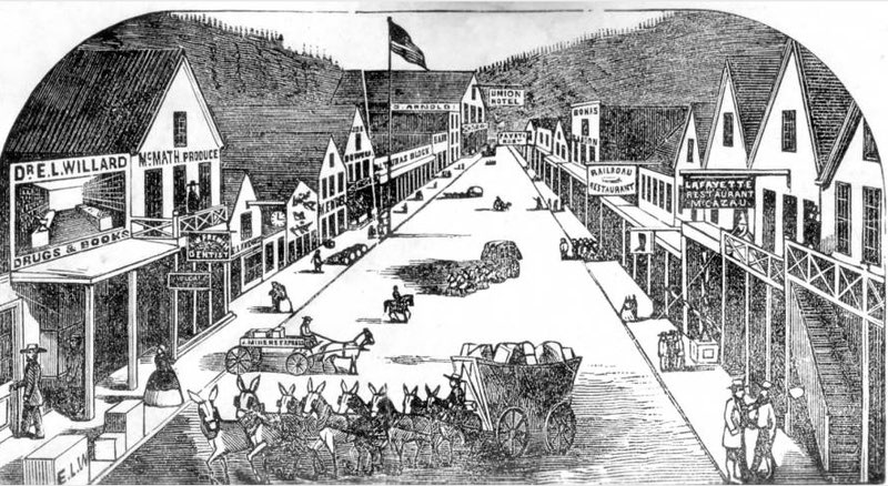
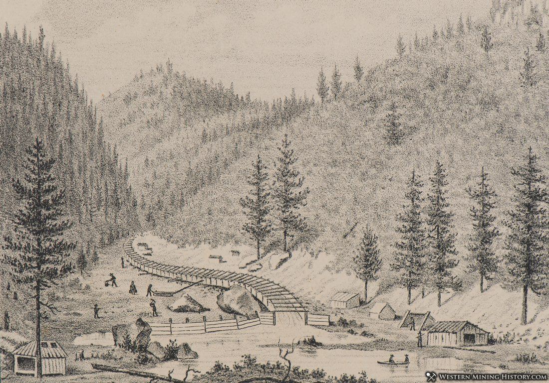
About a year after the discovery of gold Siller’s water ditch was completed and this work was rapidly followed by the construction of other privileges — Foster’s and the Martindale ditch. This opened up hydraulic mining in earnest and the town grew apace. In 1852 Eli S. Lester put up 1 the Rabitt Creek Hotel. This was the first house of any pretensions in La Porte, and the townspeople were very proud of the new structure. It stood on the north side of Main street, between Sherman’s stage barn and Runnell’s blacksmith-shop.
The next frame structure was opened as a meat market by Thomas Fregaskis and the same year Lester opened a store on Main street. Frank Everts, who had charge of the express business of Everts, Snell & Co., upon the failure of his firm in 1855, opened a general banking business in golddust. A postoffice had been established during the previous year with Landlord and Storekeeper Lester as Postmaster.
In 1855 the Mountain Messenger, a weekly paper, began publication, and about a year later the townspeople, in mass-meeting assembled, tired of the name of Rabbit Creek, decided to call the town La Porte, and a petition to that effect was accordingly forwarded to the postal department at Washington and approved three months later.
In 1858 B. W. Barnes commenced to supply the town with water from a mountain spring by a system of log pipes, and the service proved so satisfactory that it has never been changed.
Mr. Barnes still resides in La Porte, hale, hearty and wealthy. He has made considerable money in mining, and for eighteen years was Internal Revenue Collector for the Sierra division of the Northern District. Mr. Barnes has the history of every important mine in California at his tongue’s end, and possesses withal a fund of information relative to early days in California that proves exceedingly valuable to inquiring scribes and entertaining to his host of friends.
La Porte was first visited by disaster in 1861, when a fire swept away nine-tenths of the whole town. The loss was estimated at $160,000, but there was plenty of gold in the ravines and the people did not despair. They went to work and soon built up another town. Old residents of the place declare that in one month after the burning not a single trace of the conflagration could be found. In the new settlement which sprang up on the ruins of old La Porte twelve fire-proof buildings were erected. So things went on improving until 1862, when the tide turned.
At this time La Porte had reached the zenith of her prosperity, which now began to wane. There were four large hotels, fifteen stores, two churches, fourteen saloons and five gambling-houses.
The cream had been taken off, however, and the miners commenced to go away for better possibilities in virgin ground. The epoch of machinery had not been inaugurated. Spanish Flat, Secret Diggins, Barnards Claim, Whisky Diggins, Last Chance, Grass Flat, and a hundred other rich locations that had poured their yellow treasure through its arteries of trade had been worked out on the surface, and in those days it was all surface work.
A dozen big fortunes had been taken out of the section tributary to La Porte, and were already being dissipated for luxuries at London and Paris, or over the gambling tables of Monte Carlo. The rise of some was rapid in the extreme. A man named Boker struck a pocket at Spanish Flat, and took out a fortune in eight days. Since then he has resided in Paris. “Whisky Smith,” for whom Whisky Diggins was named, moved away when his secret lead was discovered, with $86,000.
Smith was an odd genius and something of a recluse. He lived alone on his claim, and only visited La Porte when his whisky gave out. Upon these visits he was frequently interrogated by the miners as to the amount taken out of his claim from day to day. Smith’s stereotyped reply was, “Not much; just enough for whisky.” One day a miner chanced to walk through the open door of his cabin, and found the hermit, with the results of his months of labor, spread out before him. “You have a fortune there,” remarked the visitor. “I have enough for whisky,” replied Smith, and that night he left town after selling his precious hoarding in La Porte. Since then the claim has been known as “Whisky Diggins.”
Some men there were in the early days of La Porte who wooed not fortune but fame. Creed Haymond was one. Ex-Lieutenant Governor Johnson was another. Both men went into the town without a penny, carrying their blankets. They came out of the town two of the best known men on the Pacific Coast.
Haymond was a boy when he went to La Porte, and according to the old-timers not a very remarkable boy either. For a time he tended bar and then got to driving a pony express. Johnson kept a gambling house and made money. Finally the two went into partnership in a general merchandise store. Johnson was the brains of the business and furnished the capital. Haymond was not commercially inclined and spent a good deal of time pouring over a set of law books, which he had borrowed from B. W. Barnes.
After a time Johnson complained that Haymond was neglecting the business and advised him to retire. Haymond acted upon this suggestion and in a few months was admitted to the bar, from which time his raise was rapid. Johnson was sent to the Legislature two or three times from Sierra County and finally became Lieutenant-Governor of the State.
The fall of La Porte was nearly as rapid as her rise. In 1869 a second tire swept the town and took all of Main street. The Alturas block alone remained, with a badly damaged roof. Two years later the town was visited by another blaze, which left only a portion of what the other fires had overlooked.
Five or six years ago many of those who had left in the early 60′ s returned. Somehow they recollected that considerable good ground had been left behind in the rush of the early time. Port Wine Wahoo, Poverty Hill, Morristown, Howland Flat, St. Louis, Whisky Diggins, Chandlerville and Slate Creek Canyon were reopened.
Many of these claims had been worked continuously, but on a small scale, and hardly commensurate with the possibilities as proven by recent demonstration. Then the town began to get a little of the old life. Modern methods came into vogue, and capital came to open up the rich gravel beds under swift rivers and towering mountains.
For many years it was known for a certainty that the ridges running down from Pilot Peak dividing the headwaters of the Feather and Yuba rivers, and Slate and Canyon creeks, covered large quantities of rich gravel.
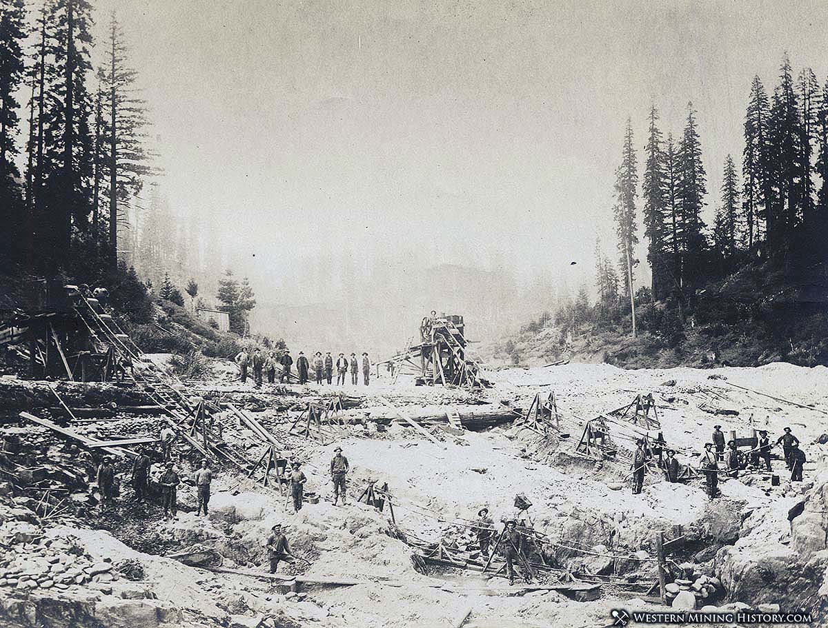
It was a question of reaching these deposits, which involved the expenditure of large sums of money. The pay-dirt could only be reached by means of long tunnels or deep shafts. In 1890 a company of Scotchmen secured two miles of this ridge. It was decided to go down to bedrock, and then, by a system of tunnels, find out where the gold lay, even if it cost a million to get there. Work was commenced on the shaft at once, and bedrock reached at a depth of 500 feet, where the richest kind of gravel was found.
Prospecting revealed the fact that they had found a channel over 600 feet wide and from five to six feet deep, extending a distance of two miles. The prospect at times showed as high as $1 to the cubic foot, and for the first three years of operation paid $30 to the pick. Since then the average has been much higher.
Over a hundred thousand dollars was spent in fitting up, and the mine is now working 120 men, under the energetic supervision of C. P. Wingate. The work is incorporated as the Feather Fork Mining Company, but is better known as the Thistle shaft.
Next in importance, in the matter of recent development of Plumas County, is a work of considerable magnitude on the middle fork of the Feather River, in which capital to the amount of eight or nine hundred thousand dollars has been invested during the past few months. The credit of opening up this vast property belongs to A. U. Rugg, a man of indomitable energy and wide practical experience in mining.
It was a problem in engineering that required some years for solution, and Mr. Rugg has at lust the satisfaction of seeing his pet scheme brought to a successful consummation. This property consists of a series of rich channel bars, stretching along the Feather for a distance of about six miles, between the mouth of Onion Valley Creek and the mouth of Washington Creek, and just above the famous Butte Bar.
Men have traveled hundreds of miles to look at this property and returned disappointed, refusing to make the descent to the canyon below, which, from the bounding ridges, presents a scene wild enough to deter the most adventuresome. From this dizzy height engineers eminent in their profession have scouted the idea of putting machinery down abrade of more than 2000 feet to the mile. Machinery, however, has been just put into the Feather River canyon during the last two months and is now in successful operation.
During the next few months half a dozen more big plants will be set going and between 500 and 600 men will find employment here. The Gold Bar Consolidated Mining Company was a leader in the experiment, and upon the success of this corporation in demonstrating the practicability of working these bars was based the activity now under way along the middle fork of the Feather.
For some months past the company has had in operation on one of the bars a fine prospecting plant — engine, derrick and pump — and a 10×6 shaft has been sunk for a distance of 22 feet. Bedrock is expected at 25 feet, and here of course the pay gravel will be found, though the prospect all the way down has been excellent, and sufficient to more than pay the expense of sinking.
Surface prospect on all of the bars shows many colors to the pan, and in some places a man could make wages in the old-fashioned way — spade and pan. The several companies have decided to pursue a uniform method of working out these bars. As a matter of fact there is but one feasible method. This is by a system of open pits, in which both steam and water power will be used from the surface.
When the bars are exhausted it will be an easy matter anrt a small expense to wingdam the river and work out the modern channel. This, however, is a matter for future consideration, as it will require from ten to fifteen years to complete the work now under way on the ancient bed of the river.
Many of the bars are heavily wooded, having trees of such size as to preclude the possibility of the ground ever having been worked over before, and it is known to a certainty, so say the experts who have examined the property, that the bedrock which stretches along this river has never been touched.
Other companies at work on the river, or about to put in machinery, are the Middle Feather River Gold Mining Company, organized in Oakland July 16, 1894. the Grizzly Placer Mining Company, the Rocky Bar Gold Mining Company, and the Hillhurst River Mining Company. A great deal of lumber will be necessary, and this will be procured from the heavily wooded ridge above, where a sawmill is to be located.
The work of constructing a wagon road leading down to the canyon is to be commenced within a few days, the estimated cost having been fixed at $3000.
Packard & Kendel are working about forty men in Slate Creek Canyon, where a new machine for handling tailings is being used successfully. This novel method will be described and illustrated in a future article. The Bald Mountain Consolidated Company, whose claim adjoins La Porte, has thirty-five men at work, with a prospect of doubling the force within the next few weeks. A tunnel has been run for something over a mile, and the prospect is excellent.
Taber mine, the stock of which is principally owned in Gibsonville and San Francisco, is working two shafts, and just above the town the American is at work on the widest channel in the county with a large force. This channel is over 2,000 feet wide, and big results are expected.
Upon an adjoining claim the Bunker Hill Company has opened up a tunnel of rich gravel. At Grass Flat, about five miles from town, the Pioneer is in operation with fifty men. The Excelsior and Happy Hollow mines are also drifting. This latter claim has already produced over two millions, and is said to be good for as much more.
At Port Wine, just across the creek from La Porte, numerous small claims have been reopened and are all doing well. The Fortuna Consolidated Mining Company is working a large force.
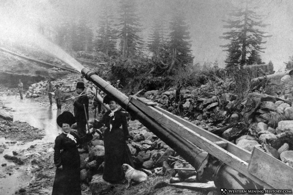
Passing down the Port Wine ridge Poverty Hill is reached, formerly one of the best paying hydraulic mines in the State. But little can be done here at drifting, though there is an immense amount of territory that would pay well under the hydraulic method.
Just below is the Iowa shaft, which shows a rich prospect. This mine was opened up several years since by Messrs, Barnes, Mussey and Harris of La Porte by an incline shaft. At Secret Diggings, across Slate Creek, about a mile from the town, Buckly will soon open up a drift mine with a large force, and at Quigleys something is being done in running a tunnel.
At Onion Valley, Poor Mans Creek and Hopkins Creek sluicing is being done, though in a small way. The Mountaineer mine at Onion Valley is soon to be opened under a new company.
The New American and the Good Hope at Saw Pit Flat are also in a fair way to feel the shock of new life that has been infused into all the veins and arteries of this once flourishing section. Besides the operations mentioned above there are hundreds of small claims where a good deal of money is being taken out. Upon many claims, where only one method of extracting the metal is possible, dams are under construction, and here hydraulicking will be resumed.
There are other sections where permission to construct dams has been refused and where drifting has been resorted to as the only chance, but on the whole mining in the vicinity of La Porte has taken on an activity of unusual extent, which promises a great deal for the prosperity of Plumas County during the next three months.
This rich corner of one of the richest mining counties in the State has been overlooked by capital, because of its severe isolation, long winters and limited transportation facilities. In the matter of transportation considerable improvement has recently been made and more is promised.
The Berg-Burroughs stage line connecting La Porte with the outside world takes its passengers through some of the finest scenery in the Sierras on comfortable roomy four and six horse coaches, fashioned something after the old Concord vehicle. The stock is kept in excellent condition, fresh horses being taken every twelve miles, and the road lies through a most interesting section of country.
Leaving Oroville at 4 a. m. passengers get breakfast at Hurlton three hours later and arrive at Forbestown at 10:30. Dinner is taken at Woodville at 12 o’clock, when connection is made with the Marysville line. From this point it is only a short ride to La Porte, which is reached at 5:30 in the evening.
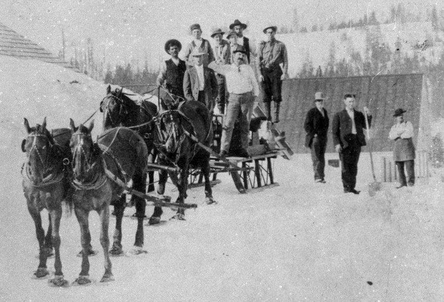
This of course is the summer schedule. During the winter things do not run so smoothly and sometimes get pretty badly mixed. With from thirty to fifty feet of snow on the road and the sudden and fierce mountain storms it is a close game and the drivers recognize the usual percentage in favor of the dealer. It is there that the horses are put on snowshoes and the towns along the road show above the white drifts only occasional patches of weather-stained roofing.